SW Everett Industrial Center
Key features
- All stations and routes would be
elevated
.
- Everett Transit and Community Transit currently serve this area with bus routes, including the Swift Green Line.
- All alternatives would be within the Paine Field/Boeing Everett Manufacturing/Industrial Center.
- Station facilities in this area include space for shuttle service to Paine Field Airport and to the Boeing Everett Production Facility.
- No new parking is planned here as part of this project.
- When Phase 1 of Everett Link opens for service (2037), the line will be open to SW Everett Industrial Center. Link light rail service will extend to Everett Station after Phase 2 construction is complete (2041).
- Station SWI-A and route SWI-1 were identified as the preferred alternatives.
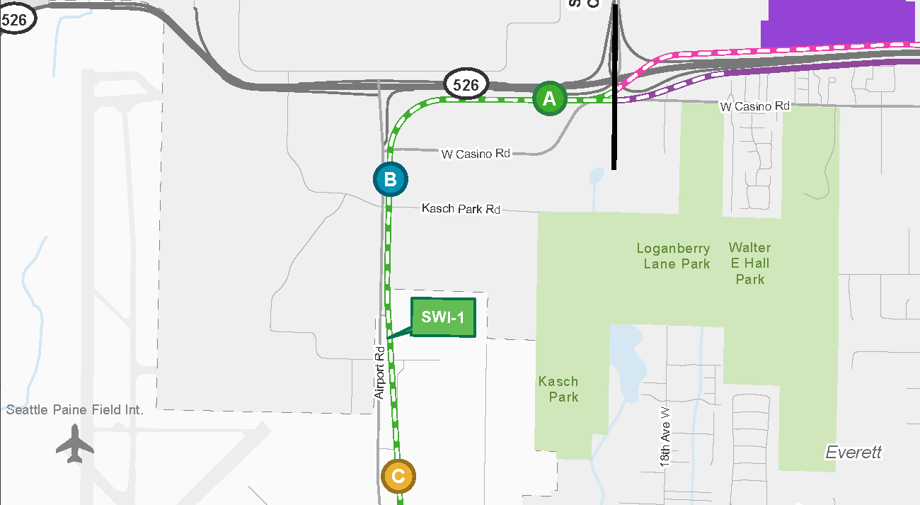 Map of the Southwest Everett Industrial Center segment. The Southwest Everett Industrial Center segment stretches from the Airport Road segment in the south to the State Route 526 / Evergreen segment in the east. There is 1 route alternative in this segment: SWI-1. There are 3 station alternatives on this route: SWI-A, SWI-B, and SWI-C. The route runs on the east side of Airport Road. Station SWI-C is located nearest Paine Field, station SWI-B is on the northside of the intersection with Kasch Park Road. The route then turns east at the intersection of State Route 526. Station SWI-A is located west of the intersection with Seaway Boulevard.
The SW Everett Industrial segment stretches from SR 99/Airport Road to Evergreen.
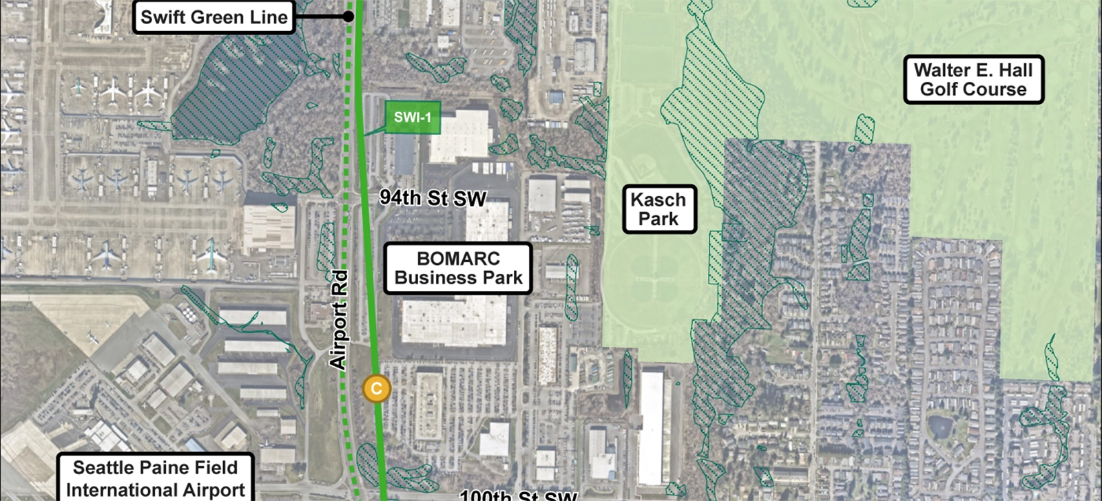 Map showing community locations and context of the surrounding neighborhood near the Southwest Everett Industrial Center segment. Key landmarks are Seattle Paine field International Airport, Boeing Everett Production Facility, Katsch Park, Walter E. Hall Park & Golf Course, and the Swift green line. There are wetlands in the area but not impacted by this alternative.
Community features in the SW Everett Industrial Center segment shown in relation to the station and route alternatives.
Alternatives
SWI-1A (Airport Road/SR 526 Alignment with SR 526 Station) – Preferred Alternative
Alternative SWI-1A consists of Alignment SWI-1 and Station SWI-A.
Alignment: SWI-1 would run elevated generally along the east side of Airport Road, curving east south of SR 526 and continuing on the south side of SR 526. The height of the
guideway
would range between approximately 25 and 75 feet high.
Station: SWI-A would be an elevated station south of SR 526 near W Casino Road, west of Seaway Blvd. The station canopy would be approximately 95 feet above the ground and would require an intermediate landing.
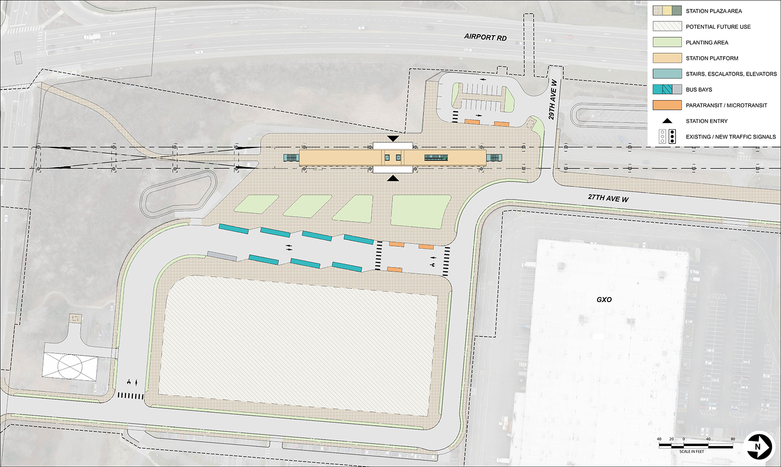
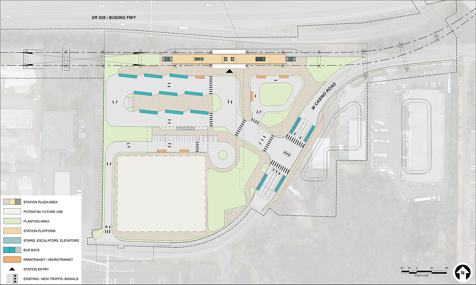 Map showing a station layout for SWI-1A located at the West end of Casino Road, south of SR 526. Bus bays are located on site and on street. Paratransit, microtransit, and pickup and dropoff spaces are on site. There is also a large area of potential future use to the south.
Early station layout for station alternative SWI-A, an elevated station located just south of SR 526 across the highway from Boeing.
SWI-1B (Airport Road/SR 526 Alignment with Kasch Park Road Station)
Alternative SWI-1B consists of Alignment SWI-1, described above, and Station SWI-B.
Station: SWI-B would be an elevated station in the vicinity of Kasch Park Road and W Casino Road. The station canopy would be approximately 65 feet above the ground.
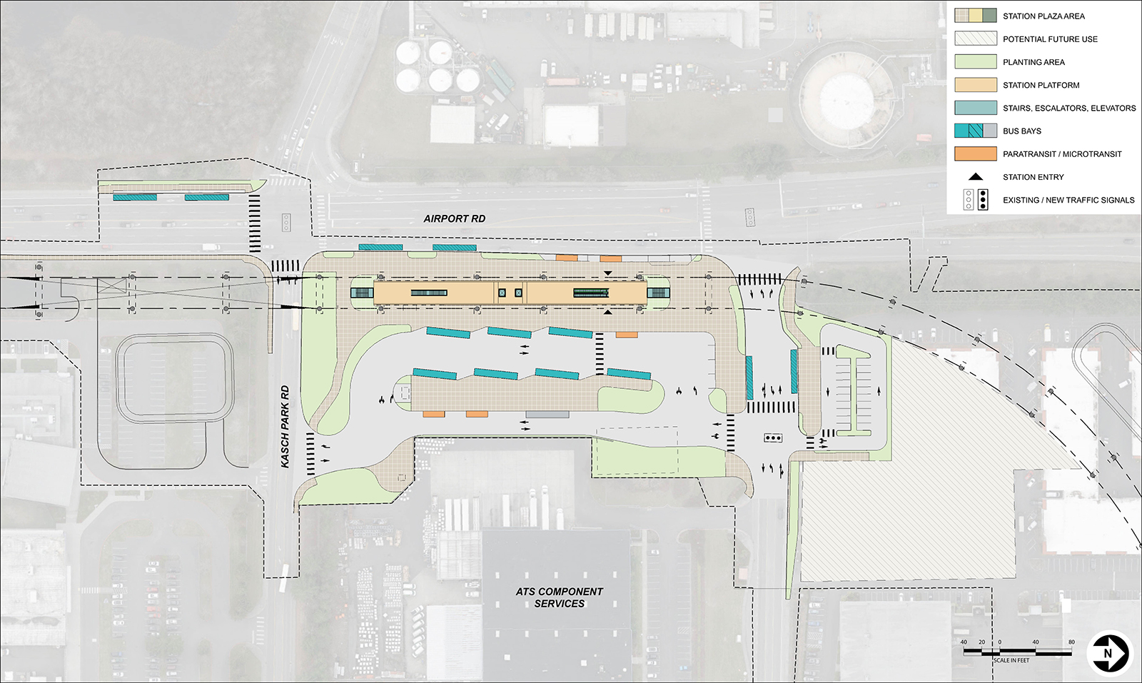 Map showing a station layout for SWI-1B located on Airport Road near Kasch Park. Bus bays and space for paratransit and microtransit are located on site and on street. There is an area of potential future use to the north.
SWI-B would be elevated about 40 feet above street level and located along the east side of Airport Road, south of Casino Road.
SWI-1C (Airport Road/SR 526 Alignment with 100th Street SW Station)
Alternative SWI-1C consists of Alignment SWI-1, described above, and Station SWI-C.
Station: SWI-C would be an elevated station in the vicinity of 100th St SW. The station canopy would be approximately 55 feet above the ground.
 Map showing a station layout for SWI-1C, located on Airport Road near Paine Field. Bus bays paratransit, microtransit, and pickup and dropoff space are all located on site. There is an area of potential future use to the east.
Early station layout for station alternative SWI-C, an elevated station located along the northeast corner of Airport Road and 100th St SW.
Lower design option
The lower design option for Alternative SWI-1A would include stretches of at-grade alignment and a lower station height, which would reduce construction complexity. The design option follows the path of Alignment SWI-1 and includes Station SWI-A but has a lower profile north of Kasch Park Road. The alignment would be at-grade north of W Casino Road, but the station would still be elevated due to the topography in the area to a maximum height of approximately 45 feet. The guideway would then return to an at-grade profile, tying into Alignment EGN-2 or EGN-3 just east of the segment break. The station canopy would be approximately 65 feet above the ground. This design option would be compatible with two of the three Build Alternatives in the adjacent SR 526/Evergreen Segment (Alternatives EGN-2B and EGN-3E but not Alternative EGN-1A).
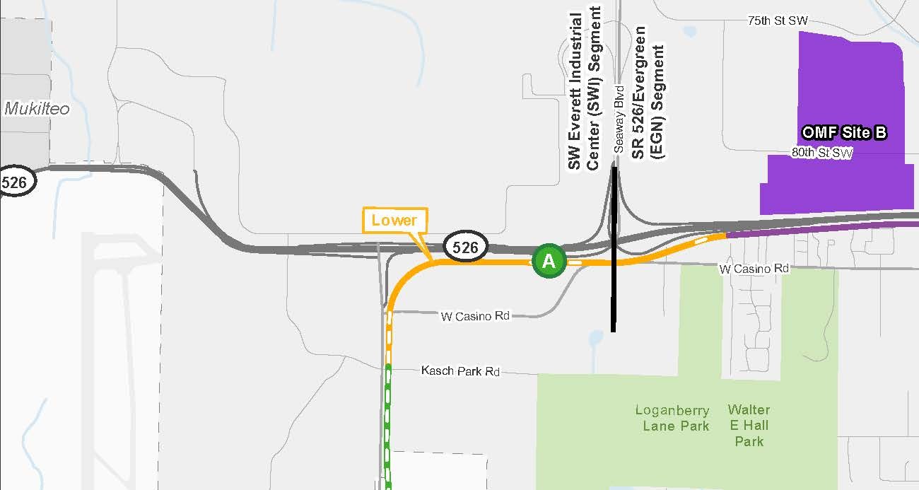 Map of the SWI-1 route but the portion running parallel to State Route 526 is at-grade instead of elevated. Station SWI-A would still be elevated.
SWI-1A with lower design option
Potential design refinements
- Explore changing SWI-1A to be at-grade to reduce costs. This would change some local street access.
- Explore moving
crossover
further away from the station at SWI-1A and SWI-1B.
Alternatives summary table
This table summarizes some of the key findings in the Draft EIS Executive Summary. To review the detailed summary of findings, visit Section 4.3.2.6 and Table 4-56 of the Draft EIS.
Summary of potential effects – SW Everett Industrial Center Segment
Notes:
a) Numbers or descriptions presented in this table are for permanent or long-term impacts, except where a construction impact is noted.
b) Opinions of probable cost are in 2025 dollars, are for comparative purposes only, and do not represent the project budget.
Please note that the information contained in the table is repeated in an outlined list below. There is no difference from the content shared in the table. It is provided in two different formats so the information is accessible to everyone.
The summary of impacts is organized by Resource Impact Measure.
Potential street closures during construction
- All alternatives: 24/7 closure of SR 526 shoulder and overnight closures of one lane.
Number of potential residential displacements
- SWI-1A, SWI-1B, and SWI-1C: None.
- SWI-1A with lower design option: 52.
Number of potential business displacements
- SWI-1A: 35.
- SWI-1A with lower design option: 37.
- SWI-1B: 29.
- SWI-1C: 30.
Displaced social resources/community facilities
Ecosystems impacts
- SWI-1A: 1.1 acres of wetlands, 150 linear feet of streams, and 0.8 acres of open space upland habitats.
- SWI-1A with lower design option: 1.2 acres of wetlands, 200 linear feet of streams, and 0.9 acres of open space upland habitats.
- SWI-1B: 0.8 acres of wetlands, 150 linear feet of streams, and 0.8 acres of open space upland habitats.
- SWI-1C: 0.9 acres of wetlands, 150 linear feet of streams, and 0.9 acres of open space upland habitats.
Number of historic properties with potential adverse effects
Opinion of probable cost in millions
- SWI-1A: $870 – 980.
- SWI-1A with lower design option: $880 – 990.
- SWI-1B: $800 – 900.
- SWI-1C: $840 – 950.
To leave a comment on the Draft EIS or the project alternatives, please fill out our Draft EIS comment form/survey. You can also learn more about what type of comments we’re looking for, how to comment, and where to comment on the Comment now page.
