Sound Transit
Español | Русский | 한국어

Everett Link Extension

Everett Link Extension
  • Welcome
  • Background
  • Environmental review
  • Alternatives
  • Next steps

banner

ANNOUNCING
Thank you for visiting our website. The content you see here was published for the EIS scoping period that was open between Jan. 23 and March 10, 2023 and is now closed. However, you can still learn more about the project and our alternatives development work below. A decision by the Sound Transit Board on the alternatives to be studied in the Draft EIS is expected in summer 2023. Visit the project website for updates and additional background information, including a Scoping Summary Report, expected to be available summer 2023.

Welcome

Preparing for environmental review

The Everett Link Extension is an ambitious mass transit system expansion that will extend Link light rail service north from Lynnwood City Center to the Everett Station area. This project will also include Operations and Maintenance Facility (OMF) North, a necessary facility to support Link light rail operations.
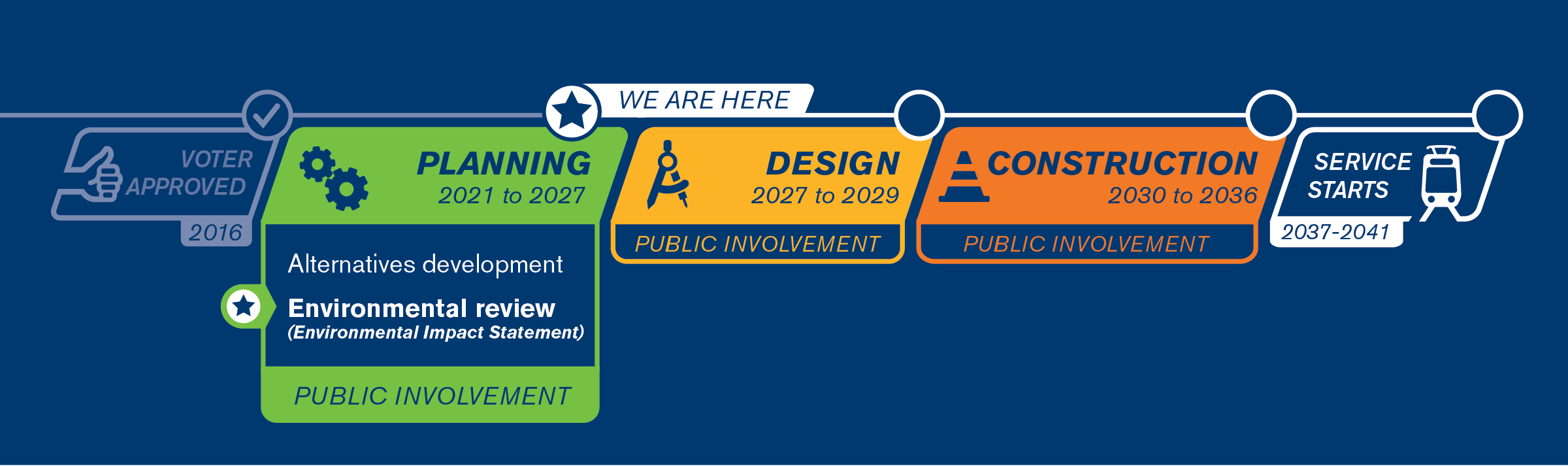
 Public input will help determine the route, station and OMF North alternatives Sound Transit will continue to study as part of the project’s next phase: environmental review.

To turn on closed captions in Spanish, Korean or Russian, select the “cc” button and then select the gear icon. After selecting the gear icon, you may change the language under “Subtitles/CC”.

About this site

This site provides:

  • Background information and outreach updates.
  • Information about the environmental review process and scoping.
  • Updated evaluation of route, station and OMF North alternatives.

email icon Subscribe for project news

Email

What is scoping?

In 2023, Sound Transit will be starting work on an environmental impact statement (EIS) click for definition for the Everett Link Extension and OMF North. In preparation for that process, we are asking the public, Tribes and agencies to provide feedback on what they would like to see studied in the EIS. This public comment period is officially known as “scoping”. Sound Transit will also coordinate with the Federal Transit Administration (FTA) on potential federal funding for the project and review of the project under the National Environmental Policy Act (NEPA).

Learn more about environmental review and scoping.

Background

About the project

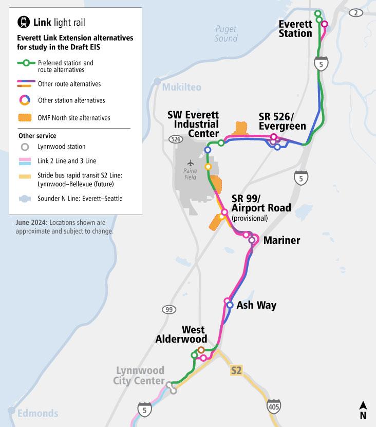
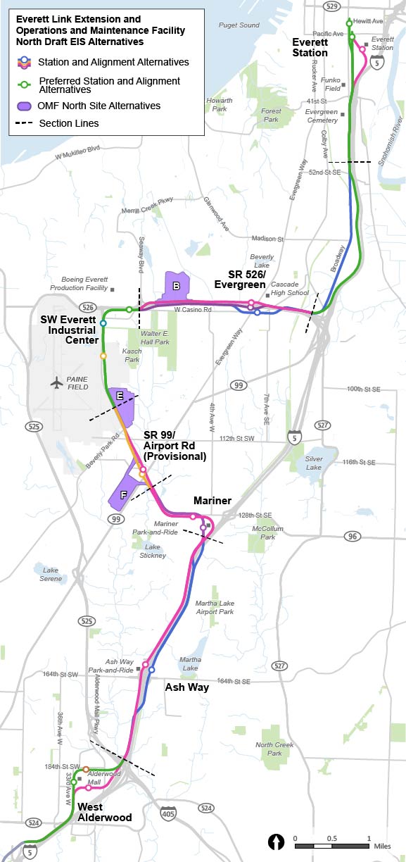
The Everett Link Extension will provide fast, reliable connections to residential and employment centers throughout the region. We’re planning to add approximately 16 miles of light rail and six new stations connecting Snohomish County residents to the regional Link light rail network. In addition, we are studying a provisional (unfunded) station click for definition through the planning process as well as parking facilities at two station locations.

The project includes the essential OMF North, which would support overall system operation and have the capacity to receive, store and service a larger train fleet to support Link extensions. To build this new facility, we need approximately 60-70+ acres near the light rail line.

Station access and parking
  • When light rail service begins, transit riders will be able to access Link via existing and new local transit connections and existing parking facilities at Everett, Ash Way and Mariner stations.
  • The Sound Transit 3 plan, or ST3, for Everett Link includes new station parking for 550 vehicles at Mariner Station and 1,000 vehicles at Everett Station.
  • To complete the light rail connection to Everett as soon as possible, the Sound Transit Board has deferred funding for parking facilities at these two stations until 2046.
  • Sound Transit will assess the potential project effects for the openings of the new stations and parking areas separately.

What we’ve done so far:

Voters approved funding for the “representative project” presented in 2016

As part of the ST3 ballot measure in 2016, voters approved funding for the representative project, which established light rail as the transit mode for the corridor, an approximate route, the number and general locations of light rail stations, and passenger access. The representative project was our starting point for project planning.

Project planning started in spring 2021

The first step in planning is called Alternatives Development, where we work with the FTA, local jurisdictions and communities to identify any additional alternative routes, stations and OMF North locations to be studied alongside the representative project. Additional alternatives must meet the project’s purpose and need.

Throughout this process, we’ve evaluated potential alternatives at progressively greater levels of detail and invited comments from the public, Tribes and agencies at each level. Our advisory groups helped to narrow down the number of alternatives and determine which ones should be moved to the next level of evaluation.

Graphic illustrating the phases of analysis and public response for the new Sound Transit Everett Link
Alternatives development has three general phases: Screening, Level 1 analysis, and Level 2 analysis. Through these phases we evaluate potential alternatives at progressively greater levels of detail and ask for feedback at each level. The comment bubbles show when we ask for public input. | Click on image to enlarge
We asked for feedback on alternatives in winter 2021

Sound Transit and the FTA provided an Early Scoping Period in November-December 2021, during which we received over 300 comments from community members, Tribes and agencies on the Everett Link Extension and OMF North project. This feedback helped shape the Level 1 evaluation of alternatives.

We completed the Level 1 alternatives analysis and asked for additional feedback in spring 2022

In March-April 2022, we shared the results of our Level 1 analysis and collected over 1,800 individual comments on the route, station and OMF North alternatives. These were shared with our agency partners, the Community Advisory Group, the Elected Leadership Group and the Sound Transit Board to help inform which alternatives would advance to the Level 2 analysis.

At that time, we also considered adding two new alignment alternatives based on Board direction around realignment and public comments received during early scoping. Ultimately, as a result of our evaluation and direction from the Elected Leadership Group, these alternatives did not move forward for further study.

In early 2023, we presented a refined set of alternatives and complete Level 2 analysis

In the Alternatives Development phase, we’re providing information on the findings from our Level 2 analysis, the final step in evaluating alternatives before environmental review. Now we’re asking the public to comment on our EIS scope. Your feedback will help Sound Transit identify which alternatives should continue to be studied in the EIS and what topics we should study. FTA may also consider this input through the NEPA process.

Project area

Map of the Everett Link Extension project area. The representative project parallels Interstate Five and continues north from Lynnwood City Center station on an elevated guideway, with a station in West Alderwood. The route continues on an elevated guideway to the next station located at the Ash Way Park and Ride. From Ash Way, the route moves northward on tracks that are surface level with the road, shifting to an elevated platform again as the train approaches Mariner Station, where additional parking is proposed. From Mariner station, the route continues on an elevated guideway in a northwest direction, with a provisional station located at state route ninety-nine and Airport Road. The route continues northwest on an elevated guideway and gradually comes to surface level tracks as it enters a station near state route five two six, known as the Southwest Everett Industrial Center. The route then moves east on an elevated guideway and enters the next station on surface level tracks at state route five two six and Evergreen Way. From here, the route has mixed elevated and surface level guideways that move northward, paralleling interstate five. The final station is on an elevated guideway at the existing Everett station in downtown Everett. Additional parking is proposed at the Everett station.
The representative project, station areas and connections to other Sound Transit services | Click to enlarge

Learn more

  • Everett Link Extension web site
  • Fact sheet [English] [Korean] [Russian] [Spanish]
  • Community Engagement Guide
  • Community Engagement Factsheet [English] [Korean] [Russian] [Spanish]
  • Frequently asked questions [English] [Korean] [Russian] [Spanish]
  • Project schedule
  • Property Owner Guide

Environmental review

What is an EIS?

The next phase of this project will be environmental review, which includes the preparation of an Environmental Impact Statement click for definition. The EIS will evaluate the potential adverse or beneficial effects of the alternatives to the physical, human and natural environment and will also propose measures to avoid, minimize or mitigate significant adverse effects where appropriate. This EIS will be prepared in compliance with both the National Environmental Policy Act (NEPA) and the Washington State Environmental Policy Act (SEPA). FTA is anticipated to be the lead agency under NEPA and Sound Transit is the lead agency under SEPA. The SEPA scoping process is part of local planning and FTA could rely on it for future NEPA evaluations. Decisions made in this local SEPA scoping process may be revisited in the subsequent federal NEPA process.

The EIS will be published in two documents: a Draft EIS and a Final EIS. The Draft EIS will be made available to the public for a minimum of 45 days for review and comment. The Final EIS will address public, Tribe and agency comments; will include any necessary revisions to correct technical errors; and will add any new information that became available since the Draft EIS was published.

What is scoping?

The EIS scoping period is an opportunity for the public, Tribes and agencies to provide input on the scope of the EIS including:

  • The project’s purpose and need click for definition (see below).
  • Topics or issues to study in the EIS.
  • Light rail route/stations and OMF North site alternatives.

Your input will be shared with the Community Advisory Group (CAG), Elected Leadership Group (ELG), Sound Transit Board and FTA to help inform decision-making on the alternatives to study further in the EIS. Once all comments from this scoping process have been reviewed and recommendations have been made by the CAG and ELG, the Sound Transit Board will identify alternatives for the Draft EIS and may also identify a preferred alternative click for definition.

What will be studied in the EIS?

The EIS will comply with all applicable environmental laws, regulations and executive orders relevant to the proposed project during the environmental review process. Sound Transit proposes to address the following topics within the EIS:

  • Acquisitions, displacements and relocations
  • Air quality, including greenhouse gas emissions
  • Economics
  • Ecosystems
  • Electromagnetic fields
  • Energy
  • Environmental justice
  • Geology and soils
  • Hazardous materials
  • Historic, cultural and archeological resources including Section 106 (National Historic Preservation Act) resources and process
  • Land use
  • Noise and vibration
  • Parks and recreational resources
  • Public services, safety and security
  • Section 4(f) of U.S. Department of Transportation Act and Section 6(f) of the Land and Water Conservation Fund Act
  • Social resources, community facilities and neighborhoods
  • Transportation (traffic, freight, navigation, transit, non-motorized)
  • Utilities
  • Visual and aesthetic resources
  • Water resources

In evaluating these topics, the EIS will address direct, indirect, and cumulative effects of both the construction and the operation of the project as well as propose measures to avoid, minimize, or mitigate significant adverse effects where needed, to inform decision makers, the public, Tribes and agencies about the project. Learn more about NEPA regulations.

Project purpose and need

The purpose of the Everett Link Extension is to expand the Link light rail system from the Lynnwood City Center Link Station to the Everett Station area and provide an OMF in order to:

  • Provide high quality, rapid, reliable, accessible and efficient light rail transit service to communities in the project corridor as defined through the local planning process and reflected in the ST3 Plan.
  • Improve regional mobility by increasing connectivity and capacity in the Everett Link Extension corridor from the Lynnwood Transit Center to the Everett Station area to meet projected transit demand.
  • Connect regional centers as described in adopted regional and local land use, transportation and economic development plans and Sound Transit’s Regional Transit Long-Range Plan.
  • Implement a system that is technically and financially feasible to build, operate and maintain.
  • Expand mobility for the corridor and region’s residents, including explicit consideration for transit-dependent, low-income and minority populations.
  • Encourage equitable and sustainable growth in station areas through support of transit-oriented development click for definition and multimodal integration in a manner that is consistent with local land use plans and policies, including Sound Transit’s Equitable Transit Oriented Development Policy and Sustainability Plan.
  • Encourage convenient, safe and equitable non-motorized access to stations, such as bicycle and pedestrian connections, consistent with Sound Transit’s System Access Policy and Equity and Inclusion Policy.
  • Preserve and promote a healthy environment and economy by minimizing adverse impacts on the natural, built and social environments through sustainable and equitable practices.
  • Provide an operations and maintenance facility with the capacity to receive, test, commission, store, maintain and deploy vehicles to support the intended level of service for system-wide light rail system expansion.
  • Develop an operations and maintenance facility that supports efficient and reliable light rail service and minimizes system operating costs.

The project is needed because:

  • Chronic roadway congestion on Interstate 5 and State Route 99 – two primary highways connecting communities along the corridor – delays today’s travelers, including those using transit, and degrades the reliability of bus service traversing the corridor, particularly during commute periods.
  • These chronic, degraded conditions are expected to continue to worsen as the region’s population and employment grow.
  • Puget Sound Regional Council (the regional metropolitan planning organization) and local plans call for high-capacity transit in the corridor consistent with Puget Sound Regional Council’s VISION 2050 and Sound Transit’s Regional Transit Long-Range Plan.
  • Snohomish County residents and communities, including transit-dependent residents and low-income or minority populations, need long-term regional mobility and multimodal connectivity, as called for in the Washington State Growth Management Act.
  • Regional and local plans call for increased residential and/or employment density at and around high-capacity stations and increased options for multi-modal access.
  • Environmental and sustainability goals of the state and region, as established in Washington state law and embodied in Puget Sound Regional Council’s VISION 2050 and Regional Transportation Plan, include reducing greenhouse gas emissions by prioritizing transportation investments that decrease the vehicle miles traveled.
  • The current regional system lacks an operations and maintenance facility with sufficient capacity and suitable location to support the efficient and reliable long-term operations for system-wide light rail expansion, including the next phase of light rail expansion in Snohomish and King Counties.
  • New light rail maintenance and storage capacity needs to be available with sufficient time to accept delivery of and commission new vehicles to meet fleet expansion needs and to store existing vehicles while the new vehicles are tested and prepared.

Everett residents at WSB SLU forum in 2018
Community engagement is an important piece of the planning process.

Learn more about scoping

  • Scoping Information Report 
  • SEPA Determination of Significance
  • Early Scoping Summary Report
  • Community Guide to Alternatives Development [English] [Russian] [Korean] [Spanish] 
  • Community Guide to Scoping [English] [Russian] [Korean] [Spanish] [Khmer] [Vietnamese] [Lao] 

Tribal engagement

To effectively support Tribal participation in the identification, analysis and evaluation of the Everett Link Extension alternatives, Sound Transit consults with Tribes very early in this process. We have reached out to the following Tribes and will continue to work with them for the duration of the project:

  • Muckleshoot Indian Tribe
  • Sauk-Suiattle Indian Tribe
  • Snoqualmie Indian Tribe
  • Stillaguamish Tribe of Indians
  • Suquamish Tribe and the Port Madison Indian Reservation
  • Swinomish Indian Tribal Community
  • Tulalip Tribes
  • Confederated Tribes and Bands of the Yakama Nation
  • Duwamish*
  • Snohomish*

*Non-Federally Recognized

Alternatives

Which routes, stations and OMF North locations should we keep studying?

Below are key station area features and findings from our most recent
evaluation for the current route, station and OMF North alternatives. We
need public input to help determine which should move forward. The project
team may need to study multiple alternatives in an EIS, so your comments
will help us narrow down which options should be studied in the EIS and
which is the preferred alternative.

What criteria are studied in our evaluation?

We are studying various aspects of the project and the potential positive
and negative effects that route, station and OMF North alternatives could
have on a surrounding area. The criteria studied cover a range of topics,
including technical and financial feasibility, preliminary comparative
cost estimates and potential impacts to natural, built, and social
environments.

The findings from our evaluation listed below are focused on differences
in the alternatives’ performance. Ridership and proximity to Puget Sound Regional Council-designated centers, for example, were studied as part of our analysis; however, these criteria were not found to be notably different between station locations, therefore they are not included below. If you are interested in more information about all of the criteria we measured and the results, you can find them in the Level 2 Evaluation Report.

How to view

You can learn more about an area by clicking the area name below. From
there, you can learn about specific alternatives by clicking their names.


Learn more

  • Level 1 Evaluation Report
  • Level 2 Evaluation Report
  • Snohomish County’s Light Rail Communities
  • Metro Everett Subarea Plan
  • Lynnwood Light Rail Resolution

Project overview map

This map of the full Everett Link Extension project area shows the representative project route and stations in pink and other potential alternative routes and stations in navy blue. Sections below this are presented from south to north. Each station alternative section presents a map of each station alternative’s conceptual shape, lists key station area features, and also shows our analysis for each alternative currently being studied. Each station alternative section presents results from our analysis specific to the alternative: advantages, disadvantages, key findings and images to illustrate what the station may look like.

Map of the Everett Link Extension project area.
The representative project and station areas. | Click image to enlarge
The text below describes the image above Map of the Everett Link Extension project area. The representative project parallels Interstate Five and continues north from Lynnwood City Center station on an elevated guideway, with a station in West Alderwood. The route continues on an elevated guideway to the next station located at the Ash Way Park and Ride. From Ash Way, the route moves northward on tracks that are surface level with the road, shifting to an elevated platform again as the train approaches Mariner Station, where additional parking is proposed. From Mariner station, the route continues on an elevated guideway in a northwest direction, with a provisional station located at state route ninety-nine and Airport Road. The route continues northwest on an elevated guideway and gradually comes to surface level tracks as it enters a station near state route five two six, known as the Southwest Everett Industrial Center. The route then moves east on an elevated guideway and enters the next station on surface level tracks at state route five two six and Evergreen Way. From here, the route has mixed elevated and surface level guideways that move northward, paralleling interstate five. The final station is on an elevated guideway at the existing Everett station in downtown Everett. Additional parking is proposed at the Everett station.


West Alderwood

To navigate between the images, click the buttons on the pink toggle bar below the image caption. You may also click on the area besides the images to navigate between images.


This map reflects West Alderwood alternatives as of October 2022, which are subject to change based on public input and design considerations. 
                                Map shows the area around Alderwood Mall and where the routes run between other stations to the north and south. All route and station options for West Alderwood are located northwest of interstate five and south of state route 525. Three station alternatives are labelled ALD-B, ALD-D, and ALD-F. Two route alternatives are shown in pink and brown. Station options are labelled on the potential route lines to show where stations fall on the route alternatives. All route alternatives in this area begin on the west side of interstate five. The pink route alternative is the representative project and runs along Interstate five, then north at Thirty-Third Avenue west. It then runs south of Alderwood Mall and then continues north along the west side of interstate five. Station alternative ALD-B is on this route, located on the south side of the mall.  The ALD-brown route alternative follows 33rd avenue west north then turns east and follows 184th street southwest. Station alternative ALD-D is on 33rd avenue northwest, just north of 188th street southwest. ALD-F is on the ALD-brown route north of Alderwood Mall.


The West Alderwood section, as it stretches from Lynnwood Link to Ash Way, is shown above. The route alternatives are pictured in pink and brown, and the station alternatives are shown as options B, D and F.
Map showing the West Alderwood station area with community features and destinations such as significant businesses, community services and features such as parking and existing transit. The map shows where the route and station alternatives are located compared with existing community features and destinations. The map also shows areas surrounding the station and route alternatives that include more historically underserved communities. This area is colored purple and is located in the area generally west of 36th Avenue West, which is approximately a block west of all proposed route alternatives. The map also shows areas colored light blue where incoming and future development are planned near the station. The block north of 184th Street Southwest and east of 33rd Avenue West is where future development is planned.


Community features in the West Alderwood station area, such as significant businesses, community services and zoning designations, are shown on the above map. These community features can be seen in relation to the proposed station and route alternatives.
Map showing the three West Alderwood station alternatives and their respective footprints. A pink like following Alderwood Mall Blvd/I-5 before turning north along 33rd Ave West symbolizes the representative project. The pink representative route line turns east at 188th St SW and travels between the Alderwood Mall parking garage and the mall itself. Station alternative B, symbolized by a pink circle with the letter B in it, is located on this pink line just south of the mall. The station alternative’s footprint is symbolized by a faint pink rectangular shape which covers some of the existing parking lot south of the mall. The other possible route proposed by this map is represented by a brown line, and splits off of the pink representative route where it turns east at 188th St SW and instead continues north along 33rd Ave W. Station alternative D, symbolized by a brown circle with the letter D in it, is located west of Alderwood Mall, and just north of the intersection of 33rd Ave W and 188th St. SW. The station alternative’s footprint is represented by a faint, narrow brown rectangle aligned north to south. The brown alternative route continues on 33rd Ave W north past station alternative D and curves east along 184th St SW. Station alternative F is located directly north of Alderwood Mall, and is symbolized by a brown circle with the letter F in it. The station alternative’s footprint is represented by a faint brown semi-circle like shape. The pink and brown routes converge north east of the Alderwood Mall, and the route continues north along I-5.


The West Alderwood station alternatives’ early estimates of
size and shape are shown on the map above. These
shapes include big elements of the station like the
plaza, pick-up and drop-off area and bus stops. The
project is still in the planning phase, so the size
and shape will change as we do more work.
This 3-D rendering shows a conceptual design for the elevated West Alderwood D station alternative. A white and blue Link light rail train with four cars sits on a brown track. The brown track enters in the bottom left corner of the rendering, and curves slightly before exiting in the upper right corner of the rendering. In the center of the rendering, in the middle of the length of track, a short, narrow brown rectangle symbolizes the elevated station design and is labelled station platform. The elevated station travels along the length of the track for a short distance, and is supported by two larger rectangles which reach from the ground up to the elevated track and station. Below the elevated track and station are two small looping streets which are labeled pickup/drop-off and off street bus facility. The area directly under the station itself which is not a road is colored a light tan and is labeled transit plaza. Surrounding the station area and elevated railway are a number of buildings symbolized by 3D white rectangles, including Alderwood Plaza to the northwest, and Alderwood Mall, and Alderwood Parking Garage to the north. In the bottom right corner of the rendering is a small square containing a map of the station area. The track and station are symbolized in this map by a brown line, and the viewer’s location is symbolized by a red triangle pointing northwest.


A 3-D image of West Alderwood station alternative ALD-D is pictured above. The image provides a sense of scale for a station at this location and shows big elements of the station, like the plaza, pick-up and drop-off and bus stops. The project is still in the planning phase, so the image will change and become more defined.
Photo showing a Link light rail train leaving an existing light rail station. The station is elevated from the ground level, and the rail line runs above street level. The photo shows an example of what an elevated station, like the one that will be built at West Alderwood, could look like.


A Link light rail train departs an elevated light rail station, like the one that could be built at West Alderwood.


  1.  
  2.  
  3.  
  4.  
  5.  

Key features

  • All routes and stations would be elevated.
  • Station alternatives are located in or around Alderwood Mall.
  • Community Transit serves this area with local buses and future Swift Orange Line service is planned.
  • No new parking is planned here as part of this project.
ALD-B

ALD-B would be located on the south side of Alderwood Mall within the current surface parking lot. Key findings compared to other West Alderwood station area
alternatives:

Advantages

  • None compared to ALD-D or ALD-F.

Disadvantages

  • Fewest historically underserved communities and no affordable housing within walking distance.
  • Least potential for new development near the station.
  • Hardest to walk or bike to.
ALD-D

ALD-D would be located on the west side of Alderwood Mall along 33rd Avenue W. Key findings compared to other West Alderwood station area alternatives:

Advantages

  • Best connections to planned Swift Orange Line and shortest travel times for buses to reach the station.
  • Highest planned population and job growth within walking distance.
  • Most historically underserved communities within walking distance.
  • Most community destinations within walking distance (including US Social Security Office, Virginia Mason Lynnwood Medical Center, H Mart).
  • Easiest to walk to.
  • Aligns with local planning by the City of Lynnwood.

Disadvantages

  • Less potential for new development near the station than ALD-F.
ALD-F

ALD-F station would be located on the north side of Alderwood Mall along 184th St SW. You’ll find fewer advantages and disadvantages below, because when compared to other options it tended to fall in the middle, generally performing better than ALD-B but slightly worse than ALD-D. Key findings compared to other West Alderwood station area alternatives:

Advantages

  • Most potential for new development opportunities near the station.
  • Shorter travel times for buses to reach the station than ALD-B.
  • More historically underserved communities within walking distance than ALD-B.
  • Easier to walk and bike to than ALD-B.

Disadvantages

  • Worse connection to Swift bus service than ALD-D.
  • Fewer historically underserved communities within walking distance than ALD-D.

Ash Way

To navigate between the images, click the buttons on the pink toggle bar below the image caption. You may also click on the area besides the images to navigate between images.


This map reflects the Ash Way route and station alternatives as of October 2022, which are subject to change based on public input and design considerations. The station area is shown in a zoomed-out view that illustrates the potential routes stretching from West Alderwood, through Ash Way and to Mariner. Map shows the Ash Way station area, in the Ash Way Park-and-Ride area near 164th Street southwest and interstate five. The two station alternatives shown near the area are labeled ASH-A and ASH-D. The two route alternatives shown are colored blue and pink.The pink route shows the representative project, which runs north to south and follows interstate five closely to the west, intersecting station location ASH-A located west of interstate five and east of the Ash Way park-and-ride. The pink route then continues up the west side of interstate five towards Mariner. The blue route crosses over onto the east side of interstate five south of 164th Street SW and follows Ash Way north closely, intersecting station location ASH-D located north of one hundred sixty fourth street southwest and east of Motor Place and Meadow Road.


The Ash Way section, as it stretches from West Alderwood to Mariner, is shown above. The route alternatives are pictured in pink and blue, and the station alternatives are shown as options A and D.
Map showing the Ash Way station area with community features and destinations such as significant businesses, community services and features such as parking and existing transit. The map shows where the route and station alternatives are located compared with existing community features and destinations. The map also shows areas that include more historically underserved communities, colored purple on the map. This area generally includes the neighborhood stretching north from 164th Street SW and west from interstate five.


Community features in the Ash Way station area, such as significant businesses, recreation opportunities and existing transit infrastructure, are shown on the above map. These community features can be seen in relation to the proposed station and route alternatives.
Map showing Ash Way station alternatives and their respective footprints.


The Ash Way station alternatives’ early estimates of size and shape are shown on the map above. These shapes include big elements of the station like the plaza, pick-up and drop-off area and bus stops. The project is still in the planning phase, so the size and shape will change as we do more work.
This 3-D rendering shows a conceptual design for the elevated Ash Way A station alternative. A white and blue Link light rail train with four cars sits on a pink track. The pink track enters in the top left corner of the rendering on street level, and exits on the right side of the rendering at an elevated level. In the center of the rendering, in the middle of the length of track, a short, narrow pink rectangle symbolizes the elevated station design and is labelled station platform. The elevated station travels along the length of the track for a short distance, and is supported by two larger rectangles which reach from the ground up to the elevated track and station. Below the elevated track and station are a few looping streets with buses and lined with trees. In between these streets the ground is a light tan, and this area is labelled transit plaza. Surrounding the station area and railway are a number of 3-D buildings symbolized by white rectangles, including Urban Center Apartments to the west. The Ash Way Park & Ride is directly southwest of the station, and I-5 is adjacent to the railway and station as it runs north-south directly to the west. In the bottom left corner of the rendering is a small square containing a map of the station area. The track and station are symbolized in this map by a pink line, and the viewer’s location is symbolized by a red triangle pointing northeast


A 3-D image of Ash Way station alternative ASH-A is pictured above. The image provides a sense of scale for a station at this location and shows big elements of the station, like the plaza, pick-up and drop-off and bus stops. The project is still in the planning phase, so the image will change and become more defined.
This 3-D rendering shows a conceptual design for the below ground, open air Ash Way D station alternative. A white and blue Link light rail train with four cars sits on a yellow track. The yellow track enters in the bottom left corner of the rendering on street level, and disappears into a tunnel in the middle of the rendering. In the center of the rendering, in the middle of the  length of track, two rectangles symbolize the below ground, open air station design and are labelled station platform. Next to the track and station is a parking lot full of buses,  and lined with trees. In between these streets and approaching the station itself the ground is a light tan, and this area is labelled transit plaza. Surrounding the station area and railway are a number of 3-D buildings symbolized by white rectangles, including Walmart to the West.  I-5  runs parallel to the track directly to the east. In the bottom right corner of the rendering is a small square containing a map of the station area. The track and station are symbolized in this map by a yellow line, and the viewer’s location is symbolized by a red triangle pointing southeast.


A 3-D image of Ash Way station alternative ASH-D is pictured above. The image provides a sense of scale for a station at this location and shows big elements of the station, like the plaza, pick-up and drop-off and bus stops. The project is still in the planning phase, so the image will change and become more defined.
Photo showing a Link light rail train arriving at an existing light rail station during the early morning as the sun rises with Mount Rainier in the background. The station is elevated from the ground level, and the rail line runs above street level. The photo shows an example of what an elevated station, like the one that will be built at Ash Way, could look like.


A Link light rail train departs an elevated light rail station, like the one that could be built at Ash Way.
Photo showing a construction worker walking along rail lines built for a future Link light rail station. The station is located below ground-level, but is an open-air station, meaning the station is not located fully underground in a tunnel. This photo shows an example of what a station could look like at Ash Way for the open station alternative.


A construction worker walks through an open-air station, like the one that could be built at Ash Way, that hasn’t yet opened to the public.


  1.  
  2.  
  3.  
  4.  
  5.  
  6.  
  7.  

Key features

  • The existing Ash Way Park-and-Ride located west of I-5 would continue to be the parking facility for transit in the area.
  • Community Transit serves this area with local and commuter buses, and future Swift Orange Line service is planned.
  • Snohomish County plans to complete a new multimodal crossing of I-5 north of 164th Street SW, which is partially funded.
ASH-A

ASH-A would be an elevated station on the west side of I-5 and the route would run at street-level north of the station. Key findings compared to other Ash Way station area alternatives:

Advantages:

  • More historically underserved communities and affordable housing.
  • Easier for buses to serve the station and Ash Way Park-and-Ride.
  • Best connections to planned Swift Orange Line.
  • Easier for cars to pick up and drop off at the station.

Disadvantages:

  • Less potential for new development near the station.
  • More potential residential displacements.
ASH-D

The ASH-D route would cross I-5 twice to locate the station on the east side of I-5. The route would run mostly at street level but would run under 164th Street SW with an open-air station below street level. Key findings compared to other Ash Way station area alternatives:

Advantages:

  • More potential for new development near the station.
  • Easy connection to the Interurban Trail.
  • Aligns with local planning by Snohomish County.

Disadvantages:

  • Fewer historically underserved communities and less affordable housing within walking distance.
  • Longer travel times for buses to serve this station and Ash Way Park-and-Ride.
  • Difficult for cars to pick up and drop off at the station.
  • Route may disrupt the Interurban Trail during construction.
  • Potential displacement of community destinations.
Mariner


To navigate between the images, click the buttons on the pink toggle bar below the image caption. You may also click on the area besides the images to navigate between images.


This map reflects the Mariner route and station alternatives as of October 2022, which are subject to change based on public input and design considerations. The station area is shown in a zoomed-out view that illustrates the potential routes stretching from the Mariner to SR 99 Airport Road. Map shows the Mariner station area, located near 128th Street SW between interstate five and 8th Avenue West. The three station alternatives shown in the area are labeled A, B and D and show where they fall on the route alternative. The three route alternatives shown are colored pink (where A is located), yellow (where B is located) and purple (where D is located). The pink route is the representative route. It runs along the west side of interstate five and turns west along the north side of 128th Street SW. Station alternative A is located just east of 8th Avenue West. The yellow route runs along the west side of interstate five and turns west along the south side of 128th Street SW. Station alternative B is located at the intersection of 128th Street SW and 8th Avenue West. The purple route turns north from the west side of interstate five to 4th Avenue West, to the west of the existing Safeway. The route then turns west to run along the north side of 128th Street SW. Station alternative D is located on 4th Avenue West, just southwest of the Safeway.


The Mariner section, as it stretches from Ash Way to SR 99 / Airport Road, is shown above. The route alternatives are pictured in pink, yellow and purple, and the station alternatives are shown as options A, B and D.
Map showing the Mariner station area with community features and destinations such as significant businesses, community services and features such as parking and existing transit. The map shows where the route and station alternatives are located compared with existing community features and destinations. The map also shows areas that include more historically underserved communities, colored purple on the map. This area encompasses the majority of the surrounding area, generally west of interstate five and north of 132nd Street SW. The map also shows the business corridor in the station area, which is congregated around 128 Street SW from interstate five to just west of 8 Avenue West.


Community features in the Mariner station area, such as significant businesses, community services and areas with historically underserved communities, are shown on the above map. These community features can be seen in relation to the proposed station and route alternatives.
The Mariner station alternatives’ estimated footprints are shown on the map above. Everett Link Extension is still in the planning phase, so the station footprints are not final.


The Mariner station alternatives’ early estimates of size and shape are shown on the map above. These shapes include big elements of the station like the plaza, pick-up and drop-off area and bus stops. The project is still in the planning phase, so the size and shape will change as we do more work.
This 3-D rendering shows a conceptual design for the elevated Mariner D station alternative. A white and blue Link light rail train with four cars sits on a yellow track. The yellow track enters in the top left corner of the rendering, and exits in the bottom right corner of the rendering. In the center of the rendering, in the middle of the length of track, a short, narrow yellow rectangle symbolizes the elevated station design and is labelled station platform. The elevated station travels along the length of the track for a short distance, and is supported by two other rectangles which reach from the ground up to the elevated track and station. Below the elevated track and station are a few small streets which are labeled pickup/drop-off and paratransit. An area next to the station itself has a parking lot with buses lined with trees. Between the parking lot and the station the ground is colored a light tan and is labeled transit plaza. Surrounding the station area and elevated railway are a number of buildings symbolized by 3D white rectangles, including Safeway directly to the northwest of the station. In the bottom left corner of the rendering is a small square containing a map of the station area. The track and station are symbolized in this map by a yellow line, and the viewer’s location is symbolized by a red triangle pointing northeast.


A 3-D image of Mariner station alternative MAR-D is pictured above. The image provides a sense of scale for a station at this location and shows big elements of the station, like the plaza, pick-up and drop-off and bus stops. The project is still in the planning phase, so the image will change and become more defined.
Photo showing a Link light rail train leaving an existing light rail station. The station is elevated from the ground level, and the rail line runs above street level. The photo shows an example of what an elevated station, like the one that will be built at Mariner, could look like.


A Link light rail train departs an elevated light rail station, like the one that could be built at Mariner.


  1.  
  2.  
  3.  
  4.  
  5.  

Key features

  • All stations and routes would be elevated.
  • Community Transit serves this area with local buses and the Swift Green Line.
  • Snohomish County is actively seeking funding for a new multimodal crossing along 130th Street across I-5 to 8th Avenue W.
  • Stations in the Mariner area are larger than other station areas because it would be a major hub for local and regional buses and a light rail transfer point.
  • The Mariner Park-and-Ride lot is west of I-5 and south of 128th Street SW.
  • Approximately 550 new parking spaces are planned at this station by 2046.
MAR-A

MAR-A would be located on the north side of 128th Street SW. This station has fewer advantages and disadvantages, because it performs better than MAR-D but worse than MAR-B. Key findings compared to other Mariner station area alternatives:

Advantages

  • Higher planned population and job growth near the station than MAR-D, but lower than MAR-B.
  • More historically underserved communities within walking distance than MAR-D, but fewer than MAR-B.

Disadvantages

  • More potential residential displacements than MAR-B, including affordable housing.
  • Business displacements on the north side of 128th Street SW.
MAR-B

MAR-B would be located on the south side of 128th Street SW. Key findings compared to other Mariner station area alternatives:

Advantages:

  • Higher planned job and population growth near the station.
  • Most historically underserved communities within walking distance.
  • Fewest potential residential displacements.
  • Easiest to walk to.

Disadvantages:

  • Business displacements on the south side of 128th Street SW.
MAR-D

MAR-D station would be located between 4th Avenue W and 8th Avenue W across the street from Mariner Park-and-Ride. Key findings compared to other Mariner station area alternatives:

Advantages

  • Aligns with local planning by Snohomish County.
  • Most potential for new development near the station.

Disadvantages

  • Fewest historically underserved communities within walking distance.
  • Most potential residential displacements, including affordable housing.
  • Hardest for cars to pick up and drop off at the station.
  • Business displacements on the north side of 128th Street SW.
SR 99 / Airport Road

To navigate between the images, click the buttons on the pink toggle bar below the image caption. You may also click on the area besides the images to navigate between images.


This map reflects the SR 99 / Airport Road route and station alternatives as of October 2022, which are subject to change based on public input and design considerations. The station area is shown in a zoomed-out view that illustrates the potential routes stretching from Airport Road and SR 99 to the intersection of Airport Road and 100th Street SW. Map shows the SR 99 / Airport Road station area, located at the intersection of the two roads. The two station alternatives shown near the area are labeled A and B. The two route alternatives shown are colored pink and yellow. The pink route shows the representative project, which runs along the north side of Airport Road, intersecting station location A just west of SR 99. The pink route then continues up the north side of Airport Road. The yellow route runs along the south side of Airport Road, intersecting station location B just west of SR 99. The yellow route then continues up the south side of Airport Road.


The SR 99 / Airport section, as it stretches from Mariner to Southwest Everett Industrial Center, is shown above. The route alternatives are pictured in pink and yellow, and the station alternatives are shown as options A and B.
Map showing the SR 99  Airport Road station area with community features and destinations such as significant businesses, community services and features such as parking and existing transit. The map shows where the route and station alternatives are located compared with existing community features and destinations. The map shows the business access area on the west side of Airport Road, just north of Center Road. The map also shows the existing Swift Green Line will remain.


Community features in the SR 99 / Airport Road station area, such as significant businesses and existing transit, are shown on the above map. These community features can be seen in relation to the proposed station and route alternatives.
he SR 99 / Airport Road station alternatives estimated footprints are shown on the map above.


The SR 99 / Airport Rd station alternatives’ early estimates of size and shape are shown on the map above. These shapes include big elements of the station like the plaza, pick-up and drop-off area and bus stops. The project is still in the planning phase, so the size and shape will change as we do more work.
This 3-D rendering shows a conceptual design for the elevated SR-99 Airport Rd B station alternative. A white and blue Link light rail train with four cars sits on a yellow track. The yellow track enters in the top left corner of the rendering, and exits in the bottom right corner of the rendering. In the center of the rendering, in the middle of the length of track, a short, narrow yellow rectangle symbolizes the elevated station design and is labelled station platform. The elevated station travels along the length of the track for a short distance, and is supported by two larger rectangles which reach from the ground up to the elevated track and station. Below the elevated track and station is a small looping street lined with trees with cars and buses which is labeled pickup/drop-off, service & security parking and paratransit. The area directly under the station itself which is not a road is colored a light tan and is labeled transit plaza. Surrounding the station area and elevated railway are a number of 3-D buildings symbolized by white rectangles, including 7-Eleven to the northeast, and public storage to the southwest.In the bottom left corner of the rendering is a small square containing a map of the station area. The track and station are symbolized in this map by a yellow line, and the viewer’s location is symbolized by a red triangle pointing northeast.


A 3-D image of SR 99 / Airport Rd station alternative AIR-B is pictured above. The image provides a sense of scale for a station at this location and shows big elements of the station, like the plaza, pick-up and drop-off and bus stops. The project is still in the planning phase, so the image will change and become more defined.
Photo showing a Link light rail train arriving at an existing light rail station during the early morning as the sun rises with Mount Rainier in the background. The station is elevated from the ground level, and the rail line runs above street level. The photo shows an example of what an elevated station, like the one that will be built at SR 99 Airport Way, could look like.


A Link light rail train departs an elevated light rail station, like the one that could be built at SR 99 / Airport Road.


  1.  
  2.  
  3.  
  4.  
  5.  

Key features:

  • This station is provisional (unfunded).
  • All stations and routes would be elevated.
  • Community Transit currently serves this area with bus routes including Swift Blue and Green lines.
AIR-A

AIR-A would be located at the northern corner of Airport Road and SR 99. Key findings compared to the other SR 99/Airport Road station area alternatives:

Advantages

  • Better connection to Swift Green Line.
  • Less disruptive to business access during construction.

Disadvantages

  • Harder for cars to pick up and drop off at the station.
AIR-B

AIR-B would be located at the western corner of Airport Road and SR 99. Key findings compared to other SR 99/Airport Road station area alternatives:

Advantages

  • More potential for new development adjacent to the station.
  • Easier for cars to pick up and drop off at the station.

Disadvantages

  • Worse connection to Swift Green Line.
  • More disruptive to business access during construction.
SW Everett Industrial Center


To navigate between the images, click the buttons on the pink toggle bar below the image caption. You may also click on the area besides the images to navigate between images.


This map reflects the Southwest Everett Industrial Center route and station alternatives as of October 2022, which are subject to change based on public input and design considerations. Map shows the Southwest Everett Industrial Center station area, located in the area where Airport Road turns right onto SR 526. The three station alternatives shown near the area are labeled A, B and C. The only route alternative is shown, colored pink. All three station alternatives are located along this route.The pink route runs along the east side of Airport Road, near Paine Field and Boeing, before turning east onto SR 526. Station C is located just north of Paine Field, station B is located near Kasch Park Road, and station A is located on SR 526 near West Casino Road.


The SW Everett Industrial Center section, as it stretches from SR 99 / Airport Road to SR 526 / Evergreen, is shown above. The only route alternative is pictured in pink, and the station alternatives are shown as options A, B and C.
Map showing the Southwest Everett Industrial Center station area with community features and destinations such as significant businesses, community services and features such as parking and existing transit. The map shows where the route and station alternatives are located compared with existing community features and destinations. The map shows significant areas such as Paine Field to the west of Airport Road, Boeing Everett Production Facility to the north of SR 526 and historically underserved communities south of SR 526 and east of Kasch Park. Existing transit is also shown, including bus routes colored gold along West Casino Road and Swift Green Line on Airport Road.


Community features in the SW Everett Industrial Center station area, such as significant businesses, Paine Field and existing transit, are shown on the above map. These community features can be seen in relation to the proposed station and route alternatives.
Text needed


The SW Everett Industrial Center station alternatives’ early estimates of size and shape are shown on the map above. These shapes include big elements of the station like the plaza, pick-up and drop-off area and bus stops. The project is still in the planning phase, so the size and shape will change as we do more work.
This 3-D rendering shows a conceptual design for the elevated SW Everett Industrial Center A station alternative. A white and blue Link light rail train with four cars sits on a pink track. The pink track enters in the bottom left corner of the rendering, and S-curves before exiting in the upper right corner of the rendering. In the center of the rendering, in the middle of the length of track, a short, narrow pink rectangle symbolizes the elevated station design and is labelled station platform. The elevated station travels along the length of the track for a short distance, and is supported by two larger pink rectangles which reach from the ground up to the elevated track and station. Below the elevated track and station are two small looping streets with cars and buses which are labeled pickup/drop-off and off street bus facility. The area directly under the station itself which is not a road is colored a light tan and is labeled transit plaza. To the south of the station area and elevated railway are a number of buildings symbolized by 3D white rectangles, including ABC Supply Co and Access Laser. SR-526/Boeing FWY runs parallel to the track just to the north of the station, and an orange arrow symbolizes a potential pedestrian bridge crossing over SR-526 and connecting to a large parking lot and the Boeing Production Facility to the north. In the bottom left corner of the rendering is a small square containing a map of the station area. The track and station are symbolized in this map by a pink line, and the viewer’s location is symbolized by a red triangle pointing northeast.


A 3-D image of SW Everett Industrial Center station alternative SWI-A is pictured above. The image provides a sense of scale for a station at this location and shows big elements of the station, like the plaza, pick-up and drop-off and bus stops. The project is still in the planning phase, so the image will change and become more defined.
This 3-D rendering shows a conceptual design for the elevated SW Everett Industrial Center C station alternative. A white and blue Link light rail train with four cars sits on a purple track. The purple track enters in the bottom left corner of the rendering, and exits in the upper right corner of the rendering. In the center of the rendering, in the middle of the length of track, a short, narrow purple rectangle symbolizes the elevated station design and is labelled station platform. The elevated station travels along the length of the track for a short distance, and is supported by two larger purple rectangles which reach from the ground up to the elevated track and station. Below the elevated track and station are two small looping tree-lined streets with cars and buses which are labeled pickup/drop-off, paratransit, and off street bus facility. The area directly under the station itself which is not a road is colored a light tan and is labeled transit plaza. Near the station area and elevated railway are a number of buildings symbolized by 3-D white rectangles, including Bomarc Business Park to the east and Boeing and Snohomish Medical Examiner to the west.  Airport Rd runs parallel to the track just to the west of the station. In the bottom right corner of the rendering is a small square containing a map of the station area. The track and station are symbolized in this map by a purple line, and the viewer’s location is symbolized by a red triangle pointing northwest.


A 3-D image of SW Everett Industrial Center station alternative SWI-C is pictured above. The image provides a sense of scale for a station at this location and shows big elements of the station, like the plaza, pick-up and drop-off and bus stops. The project is still in the planning phase, so the image will change and become more defined.
Photo showing a Link light rail train leaving an existing light rail station. The station is elevated from the ground level, and the rail line runs above street level. The photo shows an example of what an elevated station, like the one that will be built at Southwest Everett Industrial Center, could look like.


A Link light rail train departs an elevated light rail station, like the one that could be built at SW Everett Industrial Center.


  1.  
  2.  
  3.  
  4.  
  5.  
  6.  

Key features

  • All stations and routes would be elevated.
  • Everett Transit and Community Transit currently serve this area with bus routes, including the Swift Green Line.
  • All alternatives would be within the Paine Field/Boeing Everett Manufacturing/Industrial Center.
  • Stations in this area include space for shuttle service to Paine Field Airport and to the Boeing Everett Production Facility.
SWI-A

SWI-A station would be located just south of SR 526. The station could connect to a pedestrian bridge across SR 526 to the Boeing facility to the north for Boeing employees; however, it is not currently approved or funded.

Key findings compared to other SW Everett Industrial Center station area alternatives:

Advantages

  • Serves some historically underserved communities and affordable
    housing within walking distance.
  • Direct connection to Boeing Everett Production Facility and regional employment.
  • Most potential for new development near the station.
  • Easier to walk to.

Disadvantages

  • Longer travel times for buses to reach the station.
SWI-B

SWI-B would be located along the east side of Airport Road, south of Casino Road. Key findings compared to other SW Everett Industrial Center station area alternatives:

Advantages:

  • Shorter travel times for buses to reach the station.
  • Best connection to the Swift Green Line.

Disadvantages:

  • Does not serve residential areas, historically underserved communities or affordable housing.
SWI-C

SWI-C would be located along the east side of Airport Road, near 94th Street SW. Although this station is closest to Paine Field passenger terminal, it is still located ¾ mile away and would require shuttle service to the airport. Key findings compared to other SW Everett Industrial Center station area alternatives:

Advantages:

  • Easier to bike to the station.

Disadvantages:

  • Does not serve residential areas, historically underserved communities or affordable housing.
SR 526 / Evergreen


To navigate between the images, click the buttons on the pink toggle bar below the image caption. You may also click on the area besides the images to navigate between images.


This map reflects the SR 526 / Evergreen route and station alternatives as of October 2022, which are subject to change based on public input and design considerations. The station area is shown in a zoomed-out view that illustrates the potential routes stretching from Southwest Everett Industrial Center to interstate five. Map shows the SR 526 / Evergreen station area, located at the intersection of the two roads. The five station alternatives shown near the area are labeled A, B, C, D and E. The four route alternatives shown are colored pink, purple, green and blue. The pink route shows the representative project, which runs along the north side of SR 526, intersecting station location A just west of Evergreen Way. The purple route runs along the south side of SR 526, intersecting station location B just west of Evergreen Way, and station C just east of Evergreen Way. The blue route follows the same route as the purple route on the south side of SR 526 before splitting off south to run along West Casino Road near the intersection of Evergreen Way before heading back to the south side of SR 526. The green route is very similar to the blue route in that it runs along the south side of SR 526 before turning south near the intersection of West Casino Road and Evergreen Way temporarily before turning back towards SR 526.


The SR 526 / Evergreen section, as it stretches from Southwest Everett Industrial Center to the I-5 / Broadway route alignment, is shown above. The route alternatives are pictured in pink, purple, blue and green, and the station alternatives are shown as options A, B, C, D and E.


Map showing the SR 526 Evergreen station area with community features and destinations such as significant businesses, community services and features such as parking and existing transit. The map shows where the route and station alternatives are located compared with existing community features and destinations. The map shows areas with more historically underserved communities, generally located west of Evergreen Way and south of SR 526. The Interurban Trail is also shown, which is centered around SR 526 with a crossing on Holly Drive. Existing transit is also shown: Swift Blue Line along Evergreen Way and bus routes along Casino Road. An existing pedestrian bridge over SR 526 to Beverly Road is also shown on the map.


Community features in the SR 526/Evergreen station area, such as significant businesses, pedestrian infrastructure and areas with historically underserved communities, are shown on the above map. These community features can be seen in relation to the proposed station and route alternatives.


This map shows the five Evergreen Link station alternatives and their respective footprints. Station alternative A is symbolized by a pink circle labeled A. The station is located on the northwest corner of the intersection of Evergreen Way and SR-526. The station’s footprint, symbolized by a faint pink shape, sits between Beverly Lane and Evergreen Way. The station’s light rail track alternative is symbolized by a pink line and sits just north of and runs parallel to SR-526. Station alternative B is symbolized by a purple circle labeled B. The station is located southwest of the intersection of SR-526 and Evergreen Way. The station’s footprint, symbolized by two faint purple rectangle, extends south towards Casino Road. The station alternative’s light rail track, which is symbolized by a purple line, runs west to east and crosses over Evergreen Way and then crosses north over SR-526 before running parallel to SR-526 east.       Station alternative B is symbolized by a purple circle labeled B. The station is located southwest of the intersection of SR-526 and Evergreen Way. The station’s footprint, symbolized by two faint purple rectangle, extends south towards Casino Road. The station alternative’s light rail track, which is symbolized by a purple line, runs west to east parallel to SR-526 then crosses over Evergreen Way and then crosses north over SR-526 before running parallel to SR-526 east. Station alternative C is symbolized by a purple circle labelled with a C. The station is located southwest of the intersection of Evergreen Way and SR-526. The station’s footprint is symbolized by a small and faint purple square. The station alternative’s light rail track, which is symbolized by a purple line, runs west to east parallel to SR-526 and crosses over Evergreen Way before entering station alternative C then continuing east and crossing north over SR-526.  Station alternative D is symbolized by a green circle labeled D. The station is located southwest of the intersection of Casino Road and Evergreen Way. The station’s footprint, symbolized by faint green half-circle, extends south towards Fred Meyer. The station alternative’s light rail track, which is symbolized by a green line, runs west to east parallel to SR-526 before curving south over W Casino Road and entering the station, crossing Evergreen Way, then curving back north over SR-526. Station alternative E is symbolized by a blue circle labeled E. The station is located southeast of the intersection of Casino Road and Evergreen Way. The station’s footprint, symbolized by a faint blue triangle, extends southeast towards Holly Drive. The station alternative’s light rail track, which is symbolized by a blue line, runs west to east parallel to SR-526 before curving south over W Casino Road and crossing over Evergreen Way, entering the station, then curving back north over SR-526.


The SR 526 / Evergreen station alternatives’ early estimates of size and shape are shown on the map above. These shapes include big elements of the station like the plaza, pick-up and drop-off area and bus stops. The project is still in the planning phase, so the size and shape will change as we do more work.


This 3-D rendering shows a conceptual design for the elevated SR-526/Evergreen Station B station alternative. A white and blue Link light rail train with four cars sits on a purple track. The purple track enters in the left of the rendering, and exits in the upper right corner of the rendering. In the center of the rendering, in the middle of the length of track, a short, narrow purple rectangle symbolizes the elevated station design and is labelled station platform. The elevated station travels along the length of the track for a short distance, and is supported by two larger purple rectangles which reach from the ground up to the elevated track and station. Below the elevated track and station is a small looping tree-lined street with cars and buses which is labeled pickup/drop-off, and service and security parking. The area directly under the station itself which is not a road is colored a light tan and is labeled transit plaza. There are also a few white areas that are delineated by dotted lines and labelled potential future use. Near the station area and elevated railway are a number of buildings symbolized by 3-D white rectangles, including Chevron directly to the south and multifamily housing to the north.  SR-526/Boeing FWY is directly north of the station and runs parallel to the track. An orange arrow connects Beverly Lane and the multifamily housing to the station and is labelled potential pedestrian bridge replacement. The intersection of Evergreen Way and SR-526/Boeing FWY is directly northeast of the station. In the bottom left corner of the rendering is a small square containing a map of the station area. The track and station are symbolized in this map by a purple line, and the viewer’s location is symbolized by a red triangle pointing northeast.


A 3-D image of SR 526 / Evergreen station alternative EGN-B is pictured above. The image provides a sense of scale for a station at this location and shows big elements of the station, like the plaza, pick-up and drop-off and bus stops. The project is still in the planning phase, so the image will change and become more defined.


This 3-D rendering shows a conceptual design for the elevated SR-526/Evergreen Station E station alternative. A white and blue Link light rail train with four cars sits on a blue track. The blue track enters as an s-curve in the upper left corner of the rendering, and exits in the bottom right corner of the rendering. In the center of the rendering, in the middle of the length of track, a short, narrow blue rectangle symbolizes the elevated station design and is labelled station platform. The elevated station travels along the length of the track for a short distance, and is supported by two larger blue rectangles which reach from the ground up to the elevated track and station. Below the elevated track and station is a small looping tree-lined street with cars and buses. Near the station area and elevated railway are a number of buildings symbolized by 3-D white rectangles, including Dunn Lumber directly to the north and Casino Square is directly northwest of the station. SR-526/Boeing FWY is directly north of the station and runs parallel to the track. Evergreen Way runs perpendicular to the track and intersects with E Casino Road under the track, before intersecting with SR-526/Boeing FWY directly north of the station. In the bottom left corner of the rendering is a small square containing a map of the station area. The track and station are symbolized in this map by a blue line, and the viewer’s location is symbolized by a red triangle pointing northwest.


A 3-D image of SR 526 / Evergreen station alternative EGN-E is pictured above. The image provides a sense of scale for a station at this location and shows big elements of the station, like the plaza, pick-up and drop-off and bus stops. The project is still in the planning phase, so the image will change and become more defined.


Photo showing a Link light rail train arriving at an existing light rail station during the early morning as the sun rises with Mount Rainier in the background. The station is elevated from the ground level, and the rail line runs above street level. The photo shows an example of what an elevated station, like the one that will be built at SR 526 Evergreen, could look like. .


A Link light rail train departs an elevated light rail station, like the one that could be built at SR 526 / Evergreen.


Photo showing a construction worker walking along rail lines built for a future Link light rail station. The station is located below ground-level, but is an open-air station, meaning the station is not located fully underground in a tunnel. This photo shows an example of what a station could look like at Evergreen for the open station alternative.


A construction worker walks through an open-air station, like the one that could be built at SR 526 / Evergreen, that hasn’t yet opened to the public.


  1.  
  2.  
  3.  
  4.  
  5.  
  6.  
  7.  

Key features

  • Since the last public outreach period, we redesigned routes along Casino Road to minimize potential displacements. Instead of running the length of Casino Road, alternatives south of SR 526 connect to the station area closer to Evergreen Way.
  • Bus stops would be located on existing streets at all station options in this area.
  • Everett Transit and Community Transit currently serve this area with bus routes, including the Swift Blue Line.
  • No parking is included at this station as part of this project.
EGN-A

The EGN-A route would be north of SR 526 and mostly at street level. The station would be an open-air station slightly below street level and then would cross under Evergreen Way. Key findings compared to other SR 526/Evergreen station area alternatives:

Advantages:

  • Fewest potential residential displacements and displacements of community destinations.
  • Avoids business displacements along Casino Road.

Disadvantages:

  • Longest walk to Swift Blue Line and local bus service.
  • Fewer historically underserved communities and less affordable housing within walking distance.
  • Lowest planned population and job growth within walking distance.
  • Hardest to reach the station by car, only accessible by dead-end street.
  • Most streams near the route and station.
EGN-B

EGN-B station would be elevated and located at the northwest corner of the Casino Road and Evergreen Way intersection. Key findings compared to other SR 526/Evergreen station area alternatives:

Advantages

  • More historically underserved communities and affordable housing within walking distance than EGN-A and EGN-C.
  • Easy for cars to pick up and drop off at the station.

Disadvantages

  • Potential to displace community destinations near the station.
  • More potential residential displacements than EGN-A but fewer than EGN-D.
EGN-C

EGN-C station would be elevated and located at the northeast corner of the Casino Road and Evergreen Way intersection. Key findings compared to other SR 526/Evergreen station area alternatives:

Advantages:

  • Better connection to the Interurban Trail.
  • Easy for cars to pick up and drop off at the station.

Disadvantages:

  • More potential residential displacements than EGN-A but fewer than EGN-D.
  • Potential displacements of community destinations near the station.
  • Fewest historically underserved communities and less affordable housing within walking distance.
EGN-D

EGN-D station would be elevated and located at the southwest corner of the Casino Road and Evergreen Way intersection. Key findings compared to other SR 526/Evergreen station area alternatives:

Advantages:

  • Better connection to Swift Blue Line and local buses, with shorter walking distance to transfers.
  • Most historically underserved communities within walking distance.

Disadvantages:

  • Most potential residential displacements.
  • Potential displacements of community destinations.
  • Route has two crossings of Casino Road with potential for more challenging construction and disruption to businesses and residences.
EGN-E

EGN-E station would be elevated and located at the southeast corner of the Casino Road and Evergreen Way intersection. Key findings compared to other SR 526/Evergreen station area alternatives:

Advantages:

  • Better connection to Swift Blue Line and local buses, with shorter walking distance to transfers.
  • Most community destinations within walking distance (such as Emerson Elementary School, Los Guerros grocery store and Grace Lutheran Church).
  • More potential for new development near the station.
  • Better connection to the Interurban Trail.
  • Easier for cars to pick up and drop off at the station.

Disadvantages:

  • More potential residential displacements than EGN-A but fewer than EGN-D.
  • Potential displacements of community destinations.
  • Route has two crossings of Casino Road with potential for more challenging construction and disruption to businesses and residences.
I-5/Broadway


To navigate between the images, click the buttons on the pink toggle bar below the image caption. You may also click on the area besides the images to navigate between images.


This map reflects the I-5 / Broadway route and station alternatives as of October 2022, which are subject to change based on public input and design considerations. The area is shown in a zoomed-out view that illustrates the potential routes stretching from Evergreen to the area south of downtown Everett. Map shows the I-5 route alignment in this area, running along I-5 from Evergreen to downtown Everett. The map also shows the Broadway route alignment, which turns north from SR 526 near Cascade High School and runs along Broadway to downtown Everett.


The I-5 / Broadway section, as it stretches from SR 526 / Evergreen to Everett Station, is shown above. The route alternatives are pictured in pink and blue; there are no station alternatives in this section.
Photo showing a Link light rail train on a rail line that runs along a highway packed with cars during rush hour. This photo shows what a route alignment along interstate five or Broadway could look in the future.


A Link light rail train travels parallel to the highway on an existing route, which is ground-level, during rush hour. The proposed ground-level I-5 route could potentially look similar to the photo example.


  1.  
  2.  

Key features

  • This section of the project includes two route alternatives from SR 526 and I-5 to Lowell Road and I-5. This section does not include a station.
Broadway

The Broadway route would be in an open-air trench in the southern third of this section transitioning to elevated track moving north. Key findings compared to I-5 alternative:

Advantages:

  • Shorter route with fewer curves and slightly shorter travel time.

Disadvantages:

  • Much higher potential residential displacements.
  • Would potentially require permanent closure of six intersections.
  • More wetlands near the route.
I-5

The I-5 route would run at street level adjacent to the highway. Key findings compared to Broadway alternative:

Advantages:

  • Fewer potential residential displacements.
  • Would not require permanent intersection closures.

Disadvantages:

  • Limited space for light rail tracks creates a more challenging construction environment.
Everett Station

To navigate between the images, click the buttons on the pink toggle bar below the image caption. You may also click on the area besides the images to navigate between images.


This map reflects alternatives as of August 2022, which are subject to change based on public input and design considerations. Map showing area roughly bound by Interstate Five and the Snohomish River to the east, Marine View Drive and Norton Street to the west, Everett Avenue to the north, and Forty-First Street to the south. Three station alternatives are labelled as A, C, and D, and each alternative has a unique route colored pink, gold, and blue respectively. The pink station A alternative route follows Interstate Five before curving away from the freeway along Smith Avenue, with station alternative A located just south of Smith Avenue and Thirty-Third Street, adjacent to the existing Everett Station. The gold station C alternative route follows McDougall Avenue, with station alternative C located at 32nd Avenue. The blue station D alternative route follows Broadway straight through downtown Everett, with station alternative D located on Broadway in between Hewitt Avenue and Wall Street, immediately adjacent to Angel of the Winds Arena.


The Everett Station section, as it stretches from the I-5 / Broadway route alignment, is shown above. The route alternatives are pictured in pink, blue and brown, and the station alternatives are shown as options A, C and D.
This map reflects alternatives as of August 2022, which are subject to change based on public input and design considerations. This map shows the three Everett Link Station alternatives, EVT-A, EVT-C, and EVT-D, and their proximity to various community features around the community of Everett. Everett station alternative A is symbolized by a pink circle containing an A, and its accompanying route is shown as a pink line. Everett station alternative C is symbolized by an orange circle containing a C, and its accompanying route is shown as an orange line. Everett station alternative D is symbolized by a blue circle containing a D, and its accompanying route is shown as a blue line. Certain areas in the community have been highlighted. West of Broadway both north and south of Pacific Avenue is highlighted in light green, and this area has been identified as an area with higher planned population and job growth. North of Everett Ave, and a few blocks south, are highlighted in purple, and has been identified as more historically underserved communities. Between McDougal Avenue and Broadway is highlighted dark blue, and this area has been identified as Broadway and McDougall business corridors. Everett station, west of Smith avenue and south of Pacific avenue is highlighted in orange. Other community destinations are symbolized by small, light yellow dots.


Community features in the Everett Station area, such as significant businesses, existing transit infrastructure and planned growth, are shown on the above map. These community features can be seen in relation to the proposed station and route alternatives.
This map shows the three Link station alternatives for downtown Everett, and their respective footprints. Station alternative D is symbolized by a blue circle labeled D. The station is located opposite Angel of the Winds Arena on the east side of Broadway between Hewitt and Pacific Avenues. The station’s footprint, symbolized by two faint blue rectangles, extends a block east of the station’s light rail track alternative itself which is symbolized by a blue line that ends just north of Hewitt Avenue and travels south down Broadway where it exits the frame. Station alternative C is symbolized by a brown circle labeled C. The station is located west of McDougall Avenue between Pacific and 32nd Avenues. The station’s footprint, symbolized by a faint brown rectangle, covers the area between Broadway and McDougall Ave. The station’s light rail track alternative, which is symbolized by a brown line, ends just north of Pacific Avenue and travels south parallel to McDougall and Pacific Avenues where it exits the frame. Station alternative A is symbolized by a pink circle labeled A. The station is located east of Smith Avenue and just south of the existing Everett Amtrak Station. The station’s footprint, symbolized by a faint pink shape, covers the area between Smith Avenue and the existing railway. The station’s light rail track alternative, which is symbolized by a pink line, ends at the existing Everett Station, and runs alongside Smith Avenue before turning to align with I-5 and existing the frame.


The Everett Station alternatives’ early estimates of size and shape are shown on the map above. These shapes include big elements of the station like the plaza, pick-up and drop-off area and bus stops. The project is still in the planning phase, so the size and shape will change as we do more work.
This 3-D rendering shows a conceptual design for the elevated Everett A station alternative. A white and blue Link light rail train with four cars sits on a pink track. The blue track ends in the upper left corner from of the rendering at Everett Station, and exits in the bottom right corner of the rendering. In the center of the rendering, in the middle of the length of track, a short, narrow pink rectangle symbolizes the elevated station design and is labelled station platform. The elevated station travels along the length of the track for a short distance, and is supported by two larger pink rectangles which reach from the ground up to the elevated track and station. Below the elevated track and station is a small looping tree-lined street with cars and buses. The area directly under the station itself which is not a road is colored a light tan and is labeled transit plaza.Near the station area and elevated railway are a number of buildings symbolized by 3-D white rectangles. Directly to the east is an existing BNSF Freight rail which runs parallel to the track, and an existing pedestrian bridge crosses over these tracks into a Sound Transit commuter lot. Smith Ave is directly to the west of the track and station, and runs parallel to the track. In the bottom left corner of the rendering is a small square containing a map of the station area. The track and station are symbolized in this map by a pink line, and the viewer’s location is symbolized by a red triangle pointing northeast.


A 3-D image of Everett Station alternative EVT-A is pictured above. The image provides a sense of scale for a station at this location and shows big elements of the station, like the plaza, pick-up and drop-off and bus stops. The project is still in the planning phase, so the image will change and become more defined.
This 3-D rendering shows a conceptual design for the elevated Everett C station alternative. A white and blue Link light rail train with four cars sits on a red track. The red track ends in the upper left corner from of the rendering, and exits in the bottom right corner of the rendering. In the center of the rendering, in the middle of the length of track, a short, narrow red rectangle symbolizes the elevated station design and is labelled station platform. The elevated station travels along the length of the track for a short distance, and is supported by two larger red rectangles which reach from the ground up to the elevated track and station. Below the elevated track and station is a small looping tree-lined street with cars and buses. Near the station area and elevated railway are a number of buildings symbolized by 3-D white rectangles. McDougall Ave is located directly to the east of the station and Broadway is directly west of the station. Both streets run parallel to the tracks. Across McDougall is the Everett Station Park and Ride, and Everett station is just east of that. In the bottom left corner of the rendering is a small square containing a map of the station area. The track and station are symbolized in this map by a red line, and the viewer’s location is symbolized by a red triangle pointing northeast.


A 3-D image of Everett Station alternative EVT-C is pictured above. The image provides a sense of scale for a station at this location and shows big elements of the station, like the plaza, pick-up and drop-off and bus stops. The project is still in the planning phase, so the image will change and become more defined.
Blue and white Link light rail trains travel along an elevated concrete track highlighted against a blue, cloudy sky. On a two way street below a blue and white Sound Transit bus sits at a bus stop where five pedestrians wait to board. In the background an office building and parking garage are visible through various green, yellow and read trees.
                                                The photo shows an example of what an elevated station, like the one that will be built at Everett, could look like.


A Link light rail train idles at an elevated station, similar to what the proposed station in Everett could look like.


  1.  
  2.  
  3.  
  4.  
  5.  
  6.  

Key features

  • All stations and routes would be elevated.
  • Everett Station would be the northern end of the current Link system and would be a major connection hub.
  • Tracks would extend beyond the station for trains to turn around.
  • Approximately 1,000 new parking spaces are planned at this station by 2046.
  • Everett Transit and Community Transit currently serve this area with bus routes, including the Swift Blue Line.
EVT-A

EVT-A would be located at the existing Everett Station. Key findings compared to other Everett Station area alternatives:

Advantages:

  • Best connection to the transit hub at Everett Station including Swift Blue Line, Skagit Transit, Greyhound, Amtrak, Sounder and local bus service.
  • Fewest residential and business displacements.

Disadvantages:

  • Lowest planned population and job growth within walking distance.
  • Farthest from downtown and fewest community destinations within walking distance.
  • Less affordable housing within walking distance.
  • Harder to walk and bike to the station.
EVT-C

EVT-C would be located along McDougall just south of Pacific Avenue. EVT-C and EVT-D are located near each other and performed similarly in our evaluation. The main difference between EVT-C and EVT-D are impacts along McDougall compared to impacts along Broadway.

Key findings compared to other Everett Station area alternatives:

Advantages

  • More community destinations within walking distance than EVT-A (including Snohomish County Campus).
  • Higher planned population and job growth within walking distance than EVT-A.
  • More affordable housing within walking distance.
  • Most potential for new development near the station.
  • Aligns with local planning by the City of Everett.

Disadvantages

  • More potential residential displacements, including affordable housing, and potential displacement of community destinations.
  • Business displacements on McDougall Avenue.
  • Harder for cars to pick up and drop off at the station.
EVT-D

EVT-D would be located along Broadway just north of Pacific Avenue. EVT-C and EVT-D are located near each other and performed similarly in our evaluation. The main difference between EVT-C and EVT-D are impacts along McDougall compared to impacts along Broadway. Currently EVT-D is being studied to run elevated on the east side of the roadway, however, if this route is identified for further study, then we would continue exploring opportunities to minimize property impacts.

Key findings compared to other Everett Station area alternatives:

Advantages:

  • Closest to downtown and to the most community destinations within walking distance (such as North Middle School, Village Theatre, Sharing Wheels Community Bike Shop and multiple places of worship).
  • Highest planned population and job growth within walking distance.
  • Most historically underserved communities within walking distance.
  • Aligns with local planning by the City of Everett.

Disadvantages:

  • More potential residential displacements, including affordable housing, and potential displacements of community destinations.
  • Potential displacements would be more concentrated on Broadway.
  • Longer travel times for buses to serve this station option and existing Everett Station.
  • Harder for cars to pick up and drop off at the station.

Operations and Maintenance Facility North

To navigate between the images, click the buttons on the pink toggle bar below the image caption. You may also click on the area besides the images to navigate between images.


This map reflects alternatives as of August 2022, which are subject to change based on public input and design considerations. This map shows four Operation and Maintenance Facility, OMF for short, location alternatives alongside the Representative Route. The OMF Site Location alternatives are symbolized by purple shapes and the Representative Route is indicated by a pink line. The Representative Route runs adjacent to interstate 5 south and turns west alongside State Route 526. The first OMF Site Location alternative is at the intersection of state route 526 and Hardeson Road followed by another OMF Site Location Alternative at the intersection of 80th street SW and 16th Avenue. The Representative Route turns south at Airport Road, and another OMF Alternative Site Location is at the intersection of Airport Road and 100th Street southwest as the Route travels on Airport Road directly east of Paine Field. An additional OMF Site Location Alternative is located at the intersection of state route 99 and Gibson Road as the Representative Route veers southeast, following the curve of Airport Road as it turns into 128th Street southwest. The Representative Route follows 128th street southwest and curves through the Mariner Park-and-Ride to follow the course of interstate 5 South.


Potential OMF North locations are shown in the map above in relation to potential route and station alternatives. Potential OMF North sites require approximately 60-70+ acres.
This graphic shows the estimated footprints of the four Operations and Maintenance Facility alternatives, symbolized by purple shapes of various forms.In the upper left of the graphic one of the OMF site location alternatives is shown as a rectangle. This alternative’s northern edge runs adjacent to 75th street southwest, the west edge runs adjacent to 16th Avenue west, and the southern edge runs adjacent to state route 526. The west edge does not run adjacent to a road, but is bisected by 80th street southwest. In the upper right of the graphic another of the OMF site location alternatives is shown as a rectangle with one uneven side. This alternatives northern edge runs adjacent to 7th street southwest, the west edge runs adjacent to 16th Avenue west, the south edge runs adjacent to 80th street southwest. Its east edge does not run adjacent to a road. The northeast corner fits into the intersection of 75th street southwest and Hardeson road.In the bottom left of the graphic another of the OMF site location alternatives is shown as a triangle with rounded points. The site alternative’s north edge runs adjacent to no roads, the west edge runs adjacent to Airport Road, the southern tip runs adjacent to Holly drive, and the eastern edge runs adjacent to 21st avenue west, but only in the northeast corner. In the bottom left of the graphic the last OMF site alternative is shown as a rectangle. The site alternative’s north edge is not adjacent to any roads, the west edge is adjacent to Alexander road, the south edge is not adjacent to any roads, and the east edge runs adjacent to Evergreen Way


A closer view of Site SR 526 & 16th Ave and Site 75th St SW & 16th Ave, shown side-by-side. Potential OMF North sites require approximately 60-70+ acres.

This graphic shows the estimated footprints of two Operations and Maintenance Facility alternatives, symbolized by purple shapes. On the left of the graphic another of the OMF site location alternatives is shown as a triangle with rounded points. The site alternative’s north edge runs adjacent to no roads, the west edge runs adjacent to Airport Road, the southern tip runs adjacent to Holly drive, and the eastern edge runs adjacent to 21st avenue west, but only in the northeast corner. On the right of the graphic the last OMF site alternative is shown as a rectangle. The site alternative’s north edge is not adjacent to any roads, the west edge is adjacent to Alexander road, the south edge is not adjacent to any roads, and the east edge runs adjacent to Evergreen Way.


A closer view of Site Airport Rd & 100th St SW and Site SR 99 & Gibson Rd, shown side-by-side. Potential OMF North sites require approximately 60-70+ acres.

Link light rail trains sit at the existing OMF site, located in SODO near The Old Rainier Brewery, where trains are stored and receive maintenance


Link light rail trains sit at the existing OMF site, located in SODO near The Old Rainier Brewery, where trains are stored and receive maintenance.


  1.  
  2.  
  3.  
  4.  

Key features

  • Approximately 60-70+ acres are required to build an OMF facility.
  • OMF North could support more than 450 high-skilled, living-wage jobs in Snohomish County.
  • The average employee wage is more than $40 per hour, or $80,000/year, at our existing OMF facility.

Site SR 526 & 16th Ave
Key findings compared to other OMF North options:


Advantages:

  • No residential displacements.
  • Least potential to displace or negatively affect historically underserved populations.
  • Existing light industrial land use is most consistent with an operations and maintenance facility.
  • Site meets operational needs with easy connections to main line track route.
  • Fewer site development challenges.

Disadvantages:

  • Moderate number of job displacements.
  • Displaces specialized manufacturing or industrial facilities and employers.
  • Likely some impacts to wetlands and streams.

Site 75th St SW & 16th Ave
Key findings compared to other OMF North options:


Advantages:

  • No residential displacements.
  • Least potential to displace or negatively affect historically underserved populations.
  • Existing light industrial land use is most consistent with an operations and maintenance facility.
  • Lowest number of job displacements.
  • Site meets operational needs with easy connections to main line track route.

Disadvantages:

  • Displaces specialized manufacturing or industrial facilities and employers.
  • Likely some impacts to wetlands and streams.
  • Some site development challenges due to topography.

Site Airport Rd & 100th St SW
Key findings compared to other OMF North options:


Advantages:

  • Existing land use is partially consistent with an OMF facility, but also contains some residential and commercial areas.
  • Site meets operational needs with easy connections to main line.
  • Lowest property costs.
  • Lowest risk for contaminated soils.

Disadvantages:

  • Some job and residential displacements, but fewer displacements than Site SR 99 & Gibson Road.
  • Potential to displace or negatively affect some historically underserved populations.
  • Most potential impact to wetlands and streams; would require realigning two non-fish-bearing stream systems.
  • Potential for more challenging soil conditions.
  • The eastern boundary of the OMF site is next to residential areas and would likely require traffic pattern changes for these residents.

Site SR 99 & Gibson Rd
Key findings compared to other OMF North options:


Advantages:

  • No identified wetlands or streams within the site.
  • Site meets operational needs.
  • Fewer specialized manufacturing businesses to relocate.

Disadvantages:

  • Highest number of job and residential displacements, in a higher-density area.
  • Highest potential to displace or negatively affect historically underserved populations.
  • Highest property costs.
  • Existing land use (commercial, residential) is least consistent with an OMF facility.
  • Requires bridge structure over Airport Road and SR 99 to connect the site to the main route.
  • Requires moving Gibson Road, resulting in major traffic pattern changes.
  • Requires a long retaining wall along SR 99.
  • Would reduce land available for future development near the provisional SR 99/Airport Road light rail station.


Next steps

What we’ll do with your feedback

Now that we’ve shown you the latest analysis of these alternatives and asked for your input, we will share your scoping comments with the Interagency Group, Community Advisory Group, Elected Leadership Group and the Sound Transit Board.

Based on this input, the Sound Transit Board will identify alternatives — and possibly a preferred alternative for stations and alignments and the OMF North — to study in the Draft EIS. Sound Transit will coordinate with FTA on a NEPA process for the project and EIS alternatives. Project alternatives will undergo much more detailed analysis, with future opportunities for public comment.

Timeline

Graphic illustrating the project’s process from beginning to end in a simplified, condensed schedule. Graphic illustrates voters approved the Everett Link Extension project in 2016, before planning began in 2021 and is expected to run through 2026. Above the section titled “planning”, an icon indicates “we are here”. The Planning section also contains planning stages for the project, including the alternatives development phase and Environmental Review. The graphic states public involvement is involved at this phase. To the right of the Planning section, a separate section is titled “Design”, and shows the design phase running from 2026 to 2029. The graphic states public involvement is involved at this phase. To the right of the Construction section, a separate section is titled “Construction”, and shows the design phase running from 2030 to 2036. The graphic states public involvement is involved at this phase. At the far-right end of the graphic, a separate section shows service begins in 2037-2041. This means the project will open in 2037 if additional funding is acquired, and the project will open in 2041 if additional funding is not acquired.

Everett Link Extension project process. (click to enlarge)

We are expecting to publish the Draft EIS in 2024/2025 for public review and comment. This will be the next formal opportunity for public input on the project. Based on the findings of the Draft EIS and input during the public review and comment period, the Sound Transit Board will identify, reconfirm or modify the preferred alternative for the Final EIS. The next step would be the preparation and publication of the Final EIS.

The Sound Transit Board will make their official decision about which route and stations and which OMF North location to build after the Final EIS is published, which we expect to happen in or around 2026. Assuming FTA completes a NEPA process, they would issue a NEPA decision (called a Record of Decision, or ROD) after the Sound Transit Board’s decision.

Learn more about the project timeline.

How to stay engaged

Get involved

presentation icon
Request a briefing or meeting with us! We are happy to meet with you or your community group online, with opportunities to hold in-person briefings once it’s safe to do so.

Contact us

smart phone icon

Call the project line at 206-370-5533 to speak with a community engagement specialist.

email icon

Email us with questions, concerns or comments: everettlink@soundtransit.org.

Go online

checkmark icon

Learn about the project: soundtransit.org/everettlink.

website icon

Respond to online surveys.

mail letter icon

Subscribe to email updates.

social media twitter icon

Follow us on social media @SoundTransit.

What can I expect as a project neighbor?

  • If you are a resident, business or property owner near a potential Everett Link route, station or OMF North location, we encourage you to sign up for project email updates to ensure you have the most recent information.
  • The EIS process will evaluate property impacts of potential alternatives following further design work. Based on early plans, if it appears your property may be affected under any of the alternatives being studied, we will notify you in advance of the Draft EIS’s publication.
  • The Everett Link Extension route and station locations will not be finalized until the Federal Transit Administration certifies the Sound Transit Board’s project-to-be-built through a Record of Decision (part of the EIS process) which may be around 2026.
  • Information on property impacts is preliminary until we get further into design of the project, which is currently estimated to last from around 2026 to 2029.

Primary Sidebar

General questions? Contact us:

Sound Transit Community Outreach
Phone: 206-370-5533
Email: everettlink@soundtransit.org
Web: soundtransit.org/everettlink

Need assistance online or at an in-person event?

Accessibility Inquiries:
Phone: 800-201-4900, TTY Relay 711
Email: main@soundtransit.org
Monday - Friday, 7 a.m. to 7 p.m.

Additional services:

General Rider Inquiries:
Phone: 888-889-6368, TTY Relay 711
Email: main@soundtransit.org
Monday - Friday, 7 a.m. to 7 p.m.

Call or text Security 24/7: 206-398-5268

Copyright ©2022 Sound Transit

Sound Transit

Share this site with others

Follow us

Facebook icon Twitter icon Flikr icon YouTube icon Instagram icon

participate.online, a service of EnviroIssues

Copyright 2023 EnviroIssues