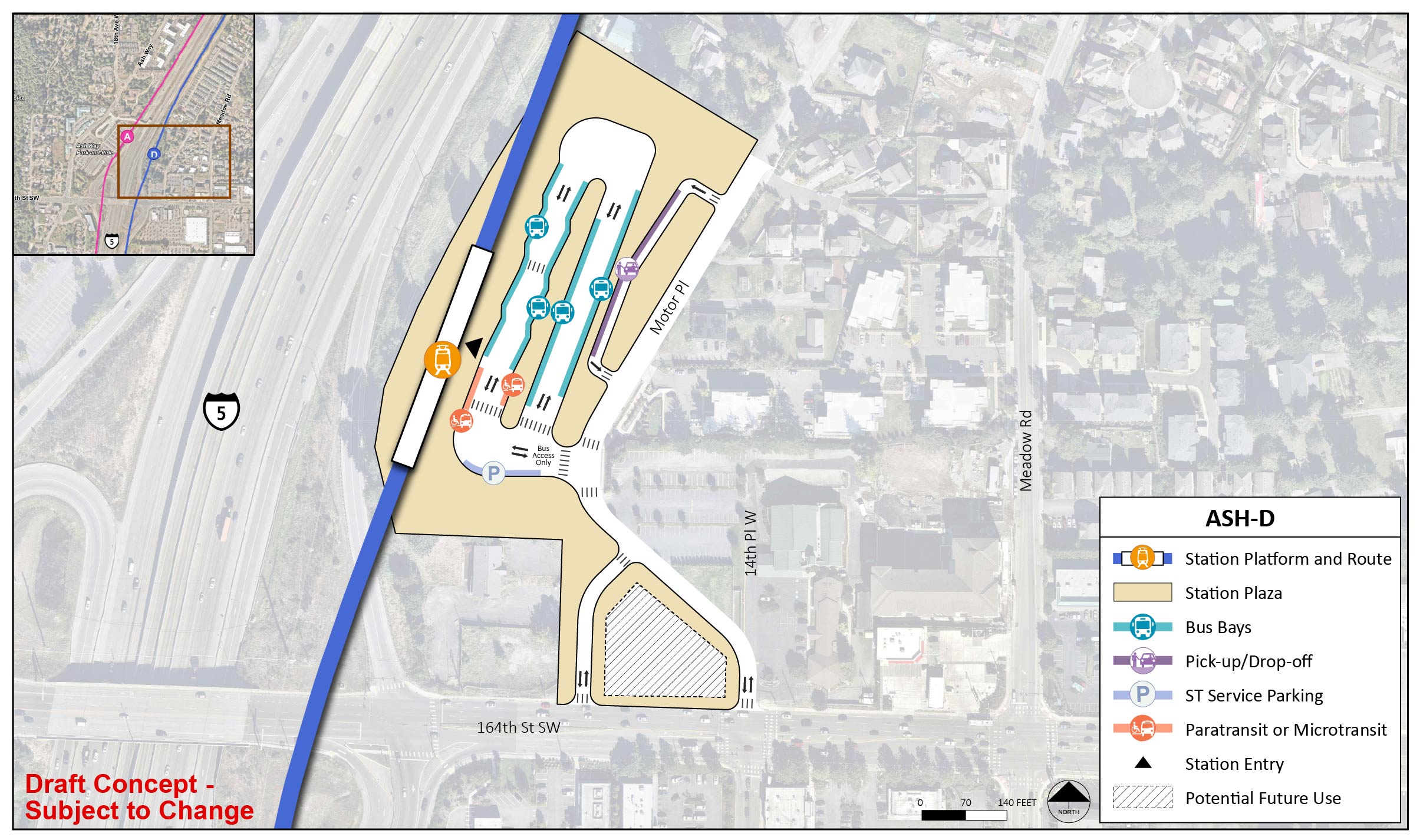
Ash Way

Key features

  • The existing Ash Way Park-and-Ride located west of I-5 would continue to be the area's parking facility.
  • Community Transit serves this area with local and commuter buses, and Swift Orange Line service.
  • Snohomish County plans to complete a new multimodal crossing of I-5 north of 164th Street SW, which is partially funded.
  • No preferred alternative was identified for this segment.

What has changed since 2023?

ASH-D has moved closer to I-5 and is now elevated instead of below street level to address engineering challenges, reduce cost, and minimize potential property acquisitions.


The Ash Way segment stretches from West Alderwood in the south to Mariner in the north. There are two route and station options indicated in two different colors; with the ASH-1 route alternative and the ASH-A station alternative both shown in pink, and the ASH-2 route alternative and the ASH-D station alternative both shown in blue. The pink ASH-1 route alternative runs along the westside of Interstate 5, mostly at street-level except for when it turns into an elevated route near the elevated ASH-A station alternative, which is located near Ash Way Park-and-Ride. The blue ASH-2 route alternative begins street-level along the westside of Interstate 5, before crossing over Interstate 5 with an elevated route south of 164th Street Southwest. The elevated ASH-D station alternative is located just north of 164th Street Southwest. The blue ASH-2 route alternative then continues north past the ASH-D station alternative in an elevated route before returning to street level a short distance north of the station, and the route continues before crossing back over to the westside of Interstate 5 as it approached the Mariner Segment.
The Ash Way segment stretches from just north of the I-5/I-405/SR 525 interchange to 134th Street SW. | Click on image to enlarge
Along the ASH-1 and ASH-2 route alternatives, there are two potential station alternatives indicated: ASH-A and ASH-D. The ASH-A station alternative is located along the ASH-1 route alternative, which follows Interstate 5 north with tracks west of the interstate. The station is located at the Ash Way Park-and Ride. The ASH-D station alternative is located along the ASH-2 route alternative, which follows Interstate 5 north with tracks east of the interstate. The station is located central to the Ash Way Park and Ride on the east side of Interstate 5.
In this Ash Way station area map, the station alternatives are shown as options A and D, and route alternatives ASH-1 and ASH-2 are pictured in pink and blue, respectively. | Click on image to enlarge

Station design elements

Below you can find early station layouts to give you an idea of what the different station alternatives may look like. These layouts are a snapshot in time and are subject to change as the design advances. As these graphics show, stations are more than just tracks and platforms. The drawings include the following station elements:

  • Pickup/drop-off: Space for personal and shared vehicles to pick up or drop off transit riders.
  • Platform: The space next to the light rail tracks where passengers wait for and move on and off trains.
  • Station entrance(s): The place where people enter or exit the Link station.
  • Potential future use: During design, a full property may be acquired by Sound Transit in order to complete construction but may not be needed for the station layout. Once construction is finished, the space could be used by Sound Transit for other project infrastructure, like stormwater ponds or electrical equipment, or developed as affordable housing or transit-oriented development projects.
  • Paratransit and microtransit: Paratransit is a transit service that provides individualized rides for people with qualifying disabilities and is supplied in accordance with the Americans with Disabilities Act. Microtransit offers an on-demand option for riders via an app, and the service is provided by vehicles smaller than a typical bus.
  • Bus bays: Designated areas for public-transit bus stops to drop off and pick up riders, providing more local connections for riders.
  • ST Service parking: Designated parking area for Sound Transit staff such as security and maintenance professionals.
  • Plaza: A public space around the station platform that includes pedestrian and bike access, connections to local bus service, and landscaping.

ASH-A

ASH-A would be an elevated station about 60 feet above street level on the west side of I-5, located at the existing Ash Way Park-and-Ride. The route (ASH-1) would run at-grade along I-5 just to the south and north of the station.

The station platform and route are located on the east end of the station area for station alternative ASH-A. The station entry point is on the south end of the platform. The station area and plaza extend to Ash Way between the Ash Way Park-and-Ride and the Urban Center Apartments. There is a lane with entry and exit points west on Ash Way and north of the station area. The lane has six bus bays and one paratransit/micro transit spot. Between this lane and Ash Way, there is potential future use. There is a lane on the south end of the station area with two pick up/drop off spot and one ST Service Parking spot.
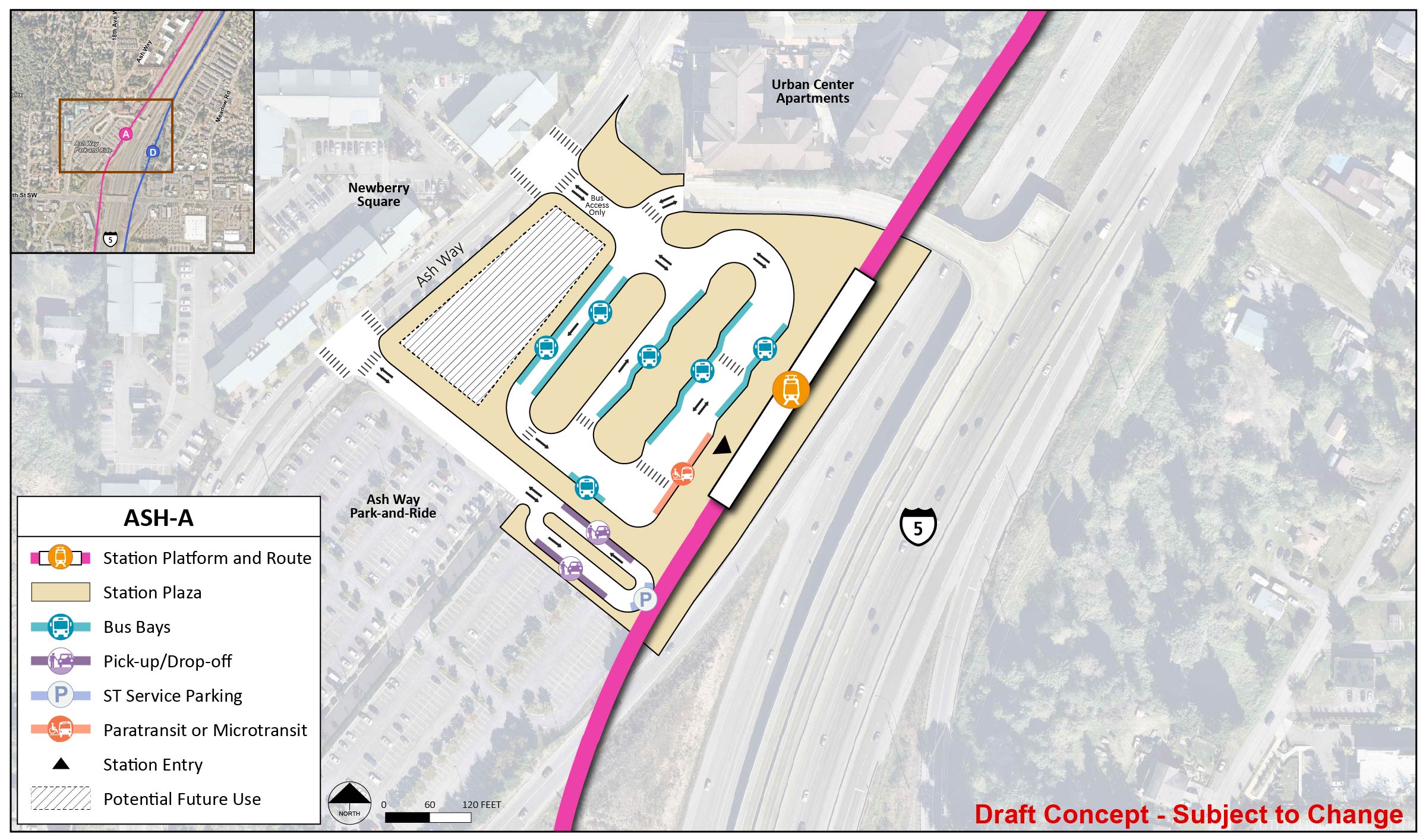
Early station layout for station alternative ASH-A, an elevated station on the west side of I-5 and adjacent to the Ash Way Park-and-Ride. | Click on image to enlarge

ASH-D

ASH-D would be an elevated station about 30 feet above street level on the east side of I-5. The ASH-2 route would cross over I-5 at two points. The route would be elevated at the station and the crossings, but would otherwise be at-grade along I-5.

The station platform and route are located on the west end of the station area for station alternative ASH-D. The station entry point is central to the platform. The station area and plaza extend to Ash Way between Ash Way Park-and-Ride and the Urban Center Apartments. There is a lane with entry and exit points west on Ash Way and north of the station area. The lane has six bus bays and one paratransit/micro transit spot. Between this lane and Ash Way, there is potential future use. There is a lane on the south end of the station area with two pick up/drop off spots and one ST Service Parking spot. The station plaza extends to include the corner of 14th Place West and 164th Street Southwest with two lanes that connect to the station area and a section for potential future use.
Early station layout for station alternative ASH-D, an elevated station located east of I-5 on 164th Street SW. | Click on image to enlarge