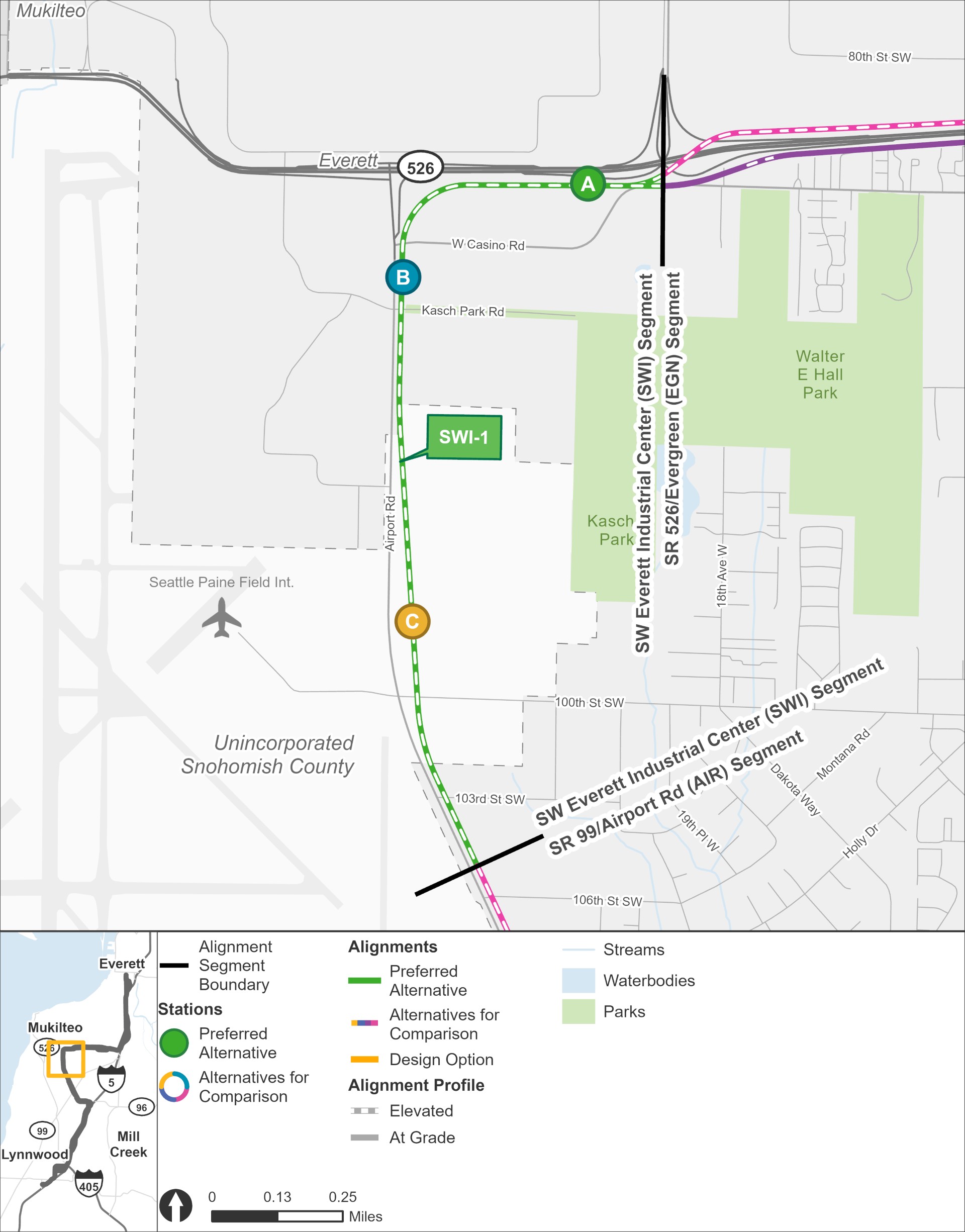
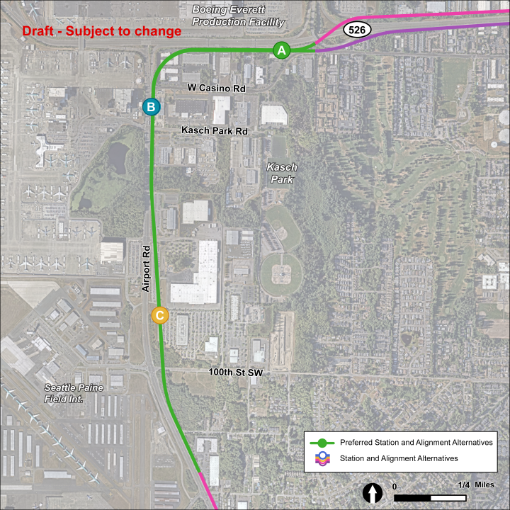
SW Everett Industrial Center

Key features

  • All stations and routes would be elevated.
  • Everett Transit and Community Transit currently serve this area with bus routes, including the Swift Green Line.
  • All alternatives would be within the Paine Field/Boeing Everett Manufacturing/Industrial Center.
  • Stations in this area include space for shuttle service to Paine Field Airport and to the Boeing Everett Production Facility.
  • No new parking is planned here as part of this project.
  • Station SWI-A and route SWI-1 were identified as the preferred alternatives.

What has changed since 2023?

Station SWI-A and route SWI-1 were identified as the preferred alternatives by the Sound Transit Board.

We are studying a design option for route SWI-1 that is lower. This would reduce the height of station SWI-A and allow a section of SWI-1 to run at ground level.

The Southwest Everett Industrial Center segment stretches from the Airport Road segment in the south to the State Route 526 / Evergreen segment in the east. The only route alternative in this segment, route alternative SWI-1, is shown in green. There are three station alternatives located on this route: SWI-A, SWI-B, and SWI-C. The SWI-1 route begins in an elevated route on the east side of Airport Road and continues on that side as it approaches the southernmost elevated station alternative, the SWI-C station, which is located nearest Paine Field. The route then continues north of the SWI-C station alternative before it reaches the SWI-B station alternative on the northside of the intersection with Kasch Park Road. The route then continues north before turning east at the intersection of State Route 526 and continues along the south side of State Route 526, before approaching the SWI-A station alternative, which is located west of the intersection with Seaway Boulevard.
The SW Everett Industrial segment stretches from SR 99/Airport Road to Evergreen. The only route alternative, SWI-1, is pictured in green, and the station alternatives are shown as options A, B, and C. | Click on image to enlarge
The SWI-1 route alternative has three station alternatives: SWI-A, SWI-B, and SWI-C. All station alternatives follow Airport Road north and eventually veer east to follow along State Route 526 with tracks on the south side on the highway. The SWI-A station is located just south of State Route 526 and north of West Casino Road. The SWI-B station is located along the east side of Airport Road to the south of Casino Road. The SWI-C station is located along the east side of Airport Road near 94th Street Southwest.
In this SW Everett Industrial Center station area map, the station alternatives are shown as options A, B, and C, and the only route alternative, SWI-1 is pictured in green. | Click on image to enlarge

Station design elements

Below you can find early station layouts to give you an idea of what the different station alternatives may look like. These layouts are a snapshot in time and are subject to change as the design advances. As these graphics show, stations are more than just tracks and platforms. The drawings include the following station elements:

  • Pickup/drop-off: Space for personal and shared vehicles to pick up or drop off transit riders.
  • Platform: The space next to the light rail tracks where passengers wait for and move on and off trains.
  • Station entrance(s): The place where people enter or exit the Link station.
  • Potential future use: During design, a full property may be acquired by Sound Transit in order to complete construction but may not be needed for the station layout. Once construction is finished, the space could be used by Sound Transit for other project infrastructure, like stormwater ponds or electrical equipment, or developed as affordable housing or transit-oriented development projects.
  • Paratransit and microtransit: Paratransit is a transit service that provides individualized rides for people with qualifying disabilities and is supplied in accordance with the Americans with Disabilities Act. Microtransit offers an on-demand option for riders via an app, and the service is provided by vehicles smaller than a typical bus.
  • Bus bays: Designated areas for public-transit bus stops to drop off and pick up riders, providing more local connections for riders.
  • ST Service parking: Designated parking area for Sound Transit staff such as security and maintenance professionals.
  • Plaza: A public space around the station platform that includes pedestrian and bike access, connections to local bus service, and landscaping.

SWI-A

SWI-A station would be elevated about 25-65 feet above street level (depending on platform design) and located just south of SR 526. The station could connect to a pedestrian bridge across SR 526 to the Boeing facility to the north for Boeing employees; however, the bridge is not currently part of this project because it has not been approved or funded. This station was identified as the preferred alternative by the Sound Transit Board.

 The station platform and route are located on the north end of the station area for station alternative SWI-A. The station entry point is between the middle and east end of the platform. The station area and plaza follow where West Casino Road curves. There is a lane with entry and exit points on the west and east end of the station area, both connect to West Casino Road. This lane has five bus bays and one paratransit/micro transit spot. There is another lane with an entrance and exit on the west side of the station that connects to West Casino Road. This lane has one paratransit/micro transit spot and one pick up/drop off spot. To the south of this lane, there is potential future use. On the east side of the station where the station area meets West Casino Road, there are four bus bays.
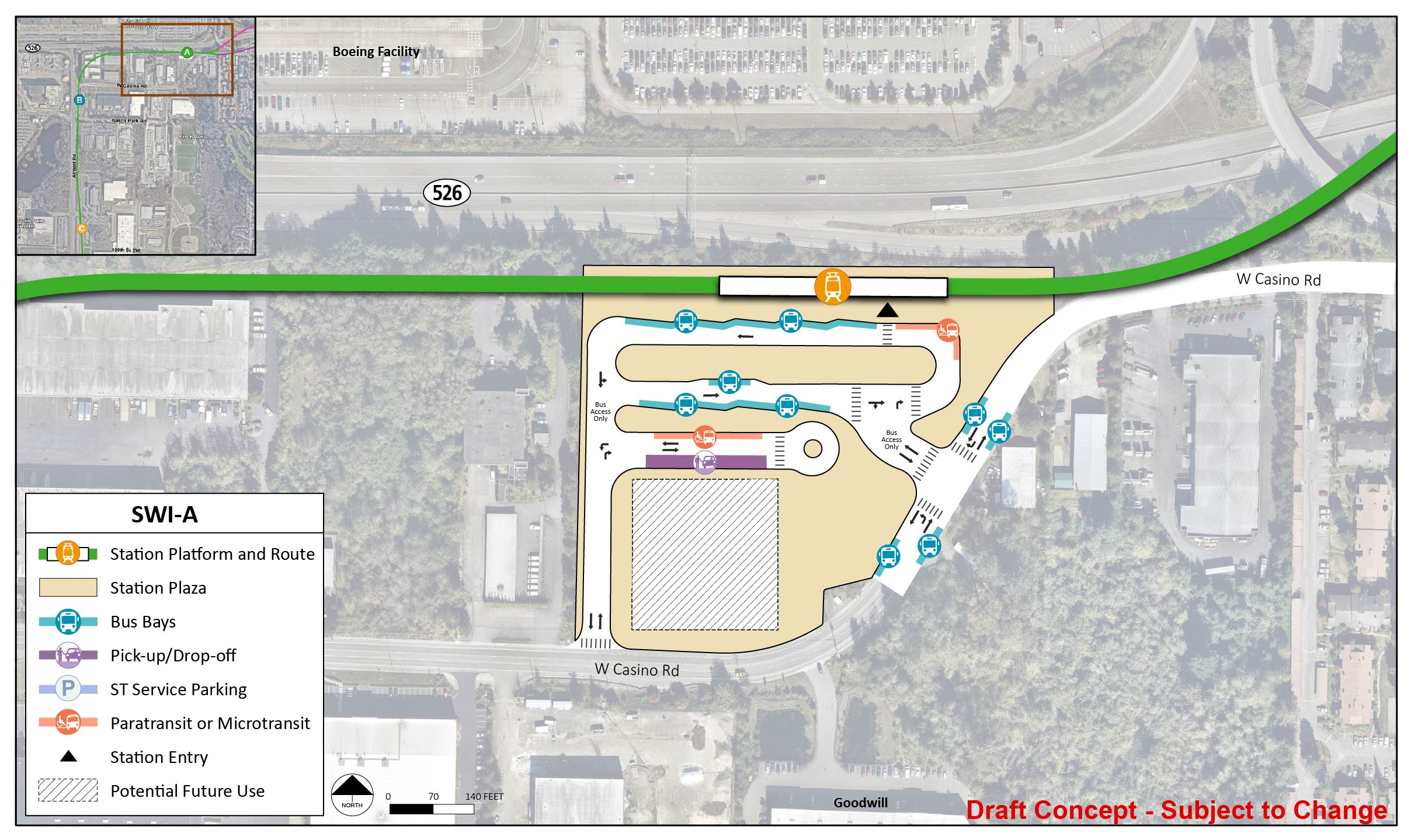
Early station layout for station alternative SWI-A, an elevated station located just south of SR 526 across the highway from Boeing. | Click on image to enlarge

SWI-B

SWI-B would be elevated about 40 feet above street level and located along the east side of Airport Road, south of Casino Road.

The station platform and route are located on the west side of the station area for station alternative SWI-B. The station entry point is in the middle of the platform. The station area and plaza extend to Airport Road, Kasch Park Road, and West Casino Road. There is a lane with entry and exit points north on West Casino Road and south on Kasch Park Road. This lane has three bus bays and three paratransit/micro transit spots. There is another lane with an entrance and exit on West Casino Road. This lane has one ST Service Parking and one pick up/drop off spot. There are two bus bays on West Casino Road and two bus bays on Airport Road.
Early station layout for station alternative SWI-B, an elevated station located along the east side of Airport Road, south of Casino Road. | Click on image to enlarge

SWI-C

SWI-C would be elevated about 30 feet above street level and located along the east side of Airport Road, near 94th Street SW. Although this station is closest to Paine Field passenger terminal, it is still located about 3/4 mile away and would require shuttle service to the airport.

The station platform and route are located on the west end of the station area for the station alternative SWI-C. The station entry point is between the middle of the platform. The station area and plaza extend to 34th Street Southwest, Airport Road, and 29th Avenue West. There is a lane east of the station platform and route with entry and exit points on 34th Street Southwest and 29th Avenue West. This lane has five bus bays and two paratransit/micro transit spots. There are two bus bays on Airport Road. On 29th Avenue West, there are two pick up/drop off spots, one paratransit/micro transit spot, and one ST Service Parking spot. There is a small lane that quickly veers off and back onto 29th Avenue West that has one pick up/drop off spot. There is potential future use in the southwest corner of the station area and plaza.
Early station layout for station alternative SWI-C, an elevated station located along the east side of Airport Road, near 94th Street SW. | Click on image to enlarge