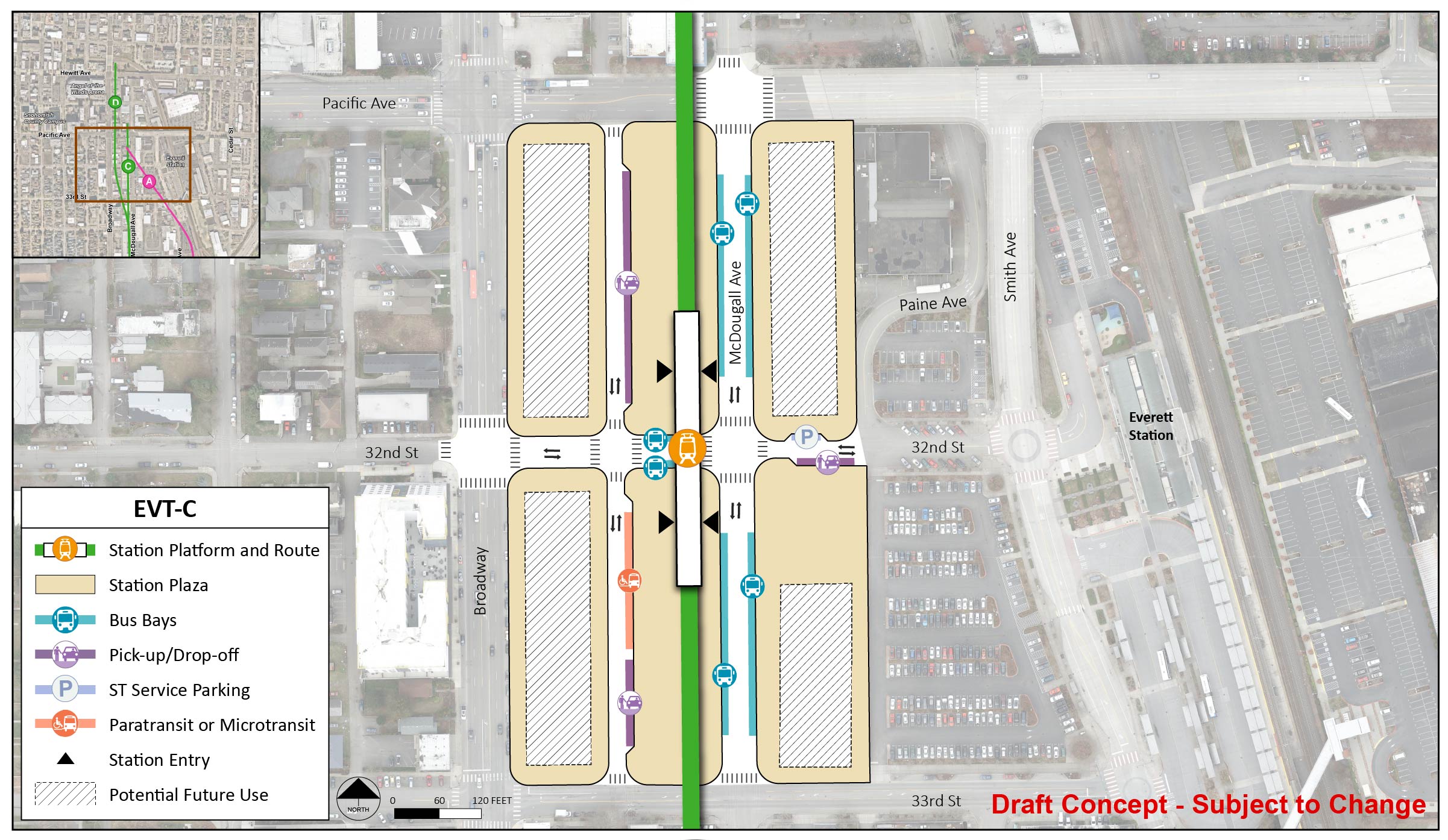
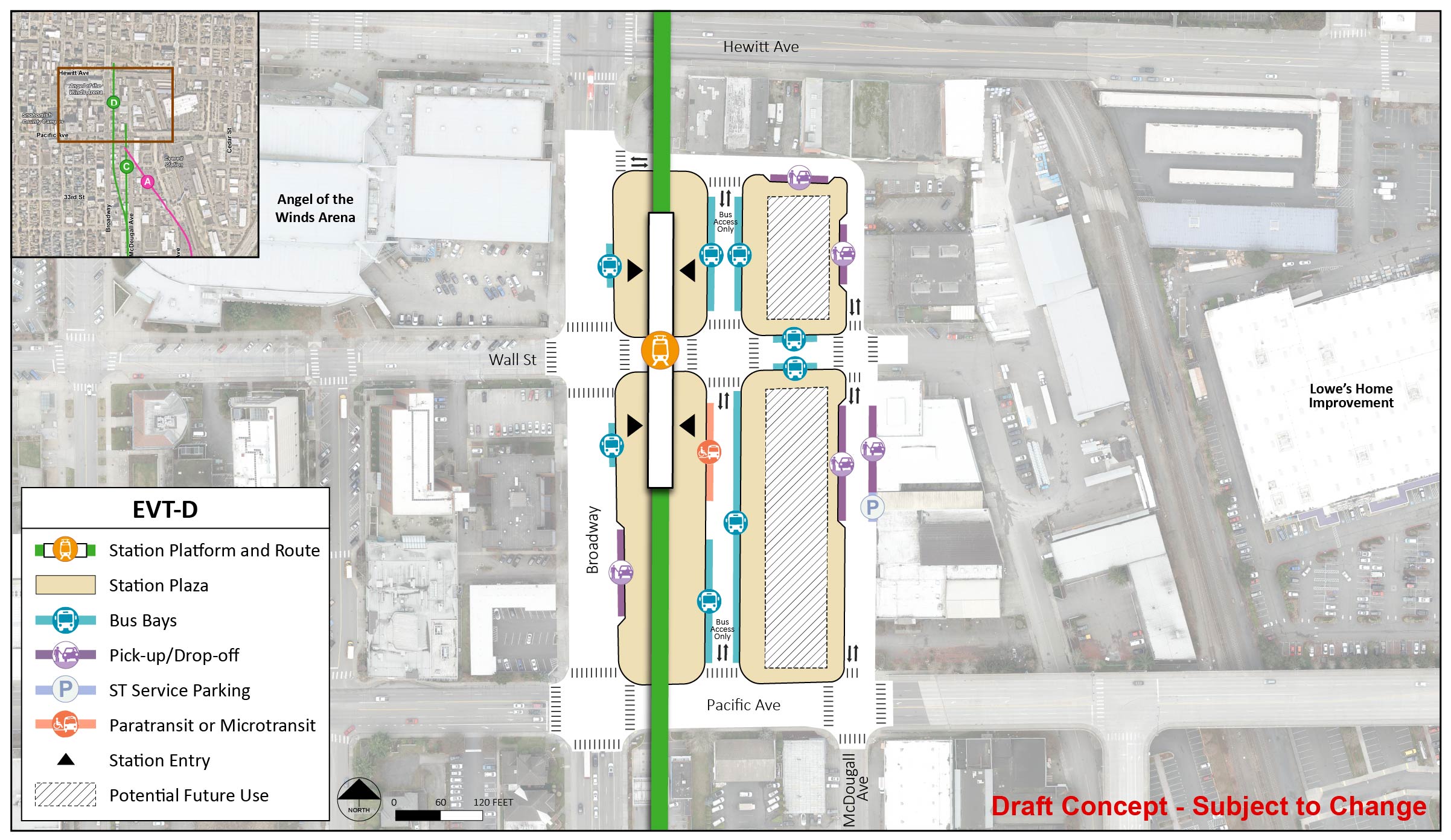
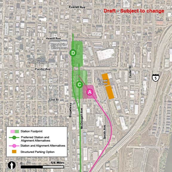
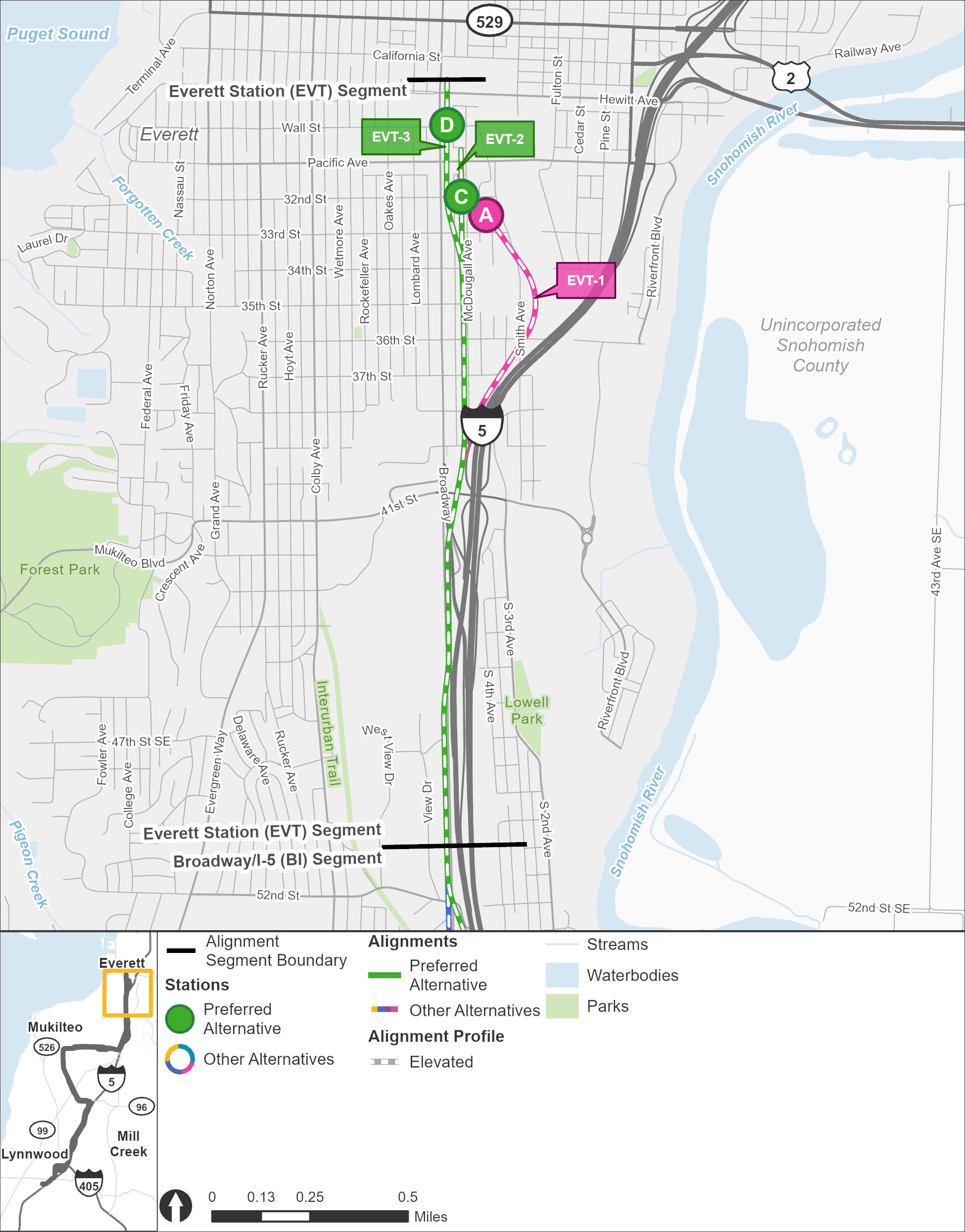
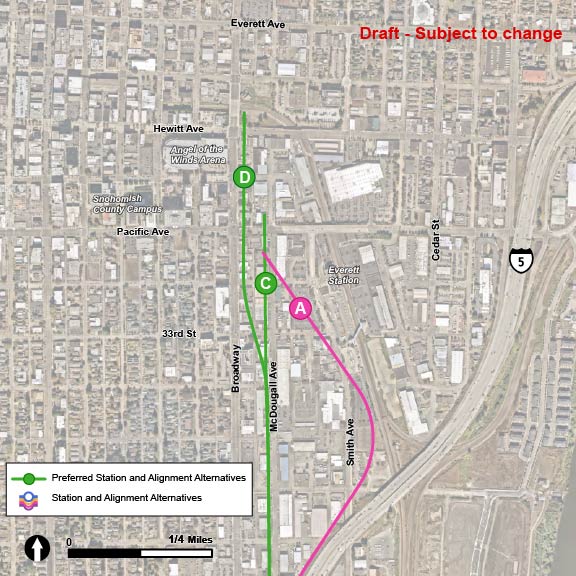
Everett Station

Key features

  • All stations and routes would be elevated.
  • When built, Everett Station would be the northern end of the Link system and would be a major connection hub.
  • Tracks would extend beyond the station for trains to turn around. This is known as the tail track.
  • Approximately 1,000 new parking spaces are planned at this station by 2046.
  • Everett Transit and Community Transit currently serve this area with bus routes, including the Swift Blue Line. Sound Transit Sounder rail service, Greyhound, and Skagit Transit also use the Everett Station.
  • Station EVT-C, station EVT-D, route EVT-2, and route EVT-3 were identified as the preferred alternatives.

What has changed since 2023?

The location of the EVT-A station shifted to the northwest to avoid conflicts with the existing Everett Station building.

Additionally, most of the EVT-3 route shifted from running along Broadway to running along McDougall, combining with the EVT-2 route. Stations EVT-C and EVT-D and routes EVT-2 and EVT-3 were identified as the preferred alternatives by the Sound Transit Board.


The Everett Station segment stretches from the Broadway-Interstate 5 segment in the south to the end of line in the north. The routes and stations are shown in different colors, with route alternative EVT-1 and station alternative EVT-A shown in pink, and route alternatives EVT-2 and EVT-3 shown in green, as well as station alternatives EVT-C and EVT-D. The green color indicates that these are the preferred alternatives. All route alternatives start at the same elevated route along the westside of Interstate 5, before the EVT-1 route breaks off from the other route alternatives to continue along the highway, before turning northwest along the existing Amtrak rail lines before approaching the elevated EVT-A station alternative, which is located west of the existing Everett Station. The EVT-2 and EVT-3 route alternatives begin the same way as the EVT-1 route alternative but breaks off as it veers from Broadway over to McDougall Avenue and continues north in an elevated route as the route approaches downtown Everett. The EVT-2 route alternative remains on McDougall Avenue as it continues north before arriving at the elevated EVT-C station, located just south of Pacific Avenue before the end of line is just north of Pacific Avenue. The EVT-3 route alternative breaks away from the EVT-2 route alternative as it veers from McDougall Avenue towards Broadway near 33rd Street, before continuing on an elevated route north as it approaches elevated station alternative EVT-D, which is located at Wall Street, before the end of line is near Hewitt Avenue.
The Everett Station segment extends from the Broadway/I-5 segment to the project’s end-of-line. Route alternatives EVT-1, EVT-2, and EVT-3 are pictured in pink and green, and the station alternatives are shown as options A, C, and D. | Click on image to enlarge
Along the EVT-1, EVT-2, and EVT-3 route alternatives, there are three station alternatives: EVT-A, EVT-C, and EVT-D. The EVT-A station alternative is located along the EVT-1 route alternative, which follows I-5 towards the north and veers to the west towards Everett Station. The EVT-A station is located west of the existing Everett Station. The EVT-C station alternative is located along the EVT-2 route alternative, which follows McDougall to the north. The EVT-C station is located along McDougall Avenue just south of Pacific Avenue. The EVT-D station alternative is located along the EVT-3 route alternative, which would run north on McDougall Avenue and shift west at 34th Street to run along Broadway. The EVT-D station is located along Broadway just north of Pacific Avenue.
In this Everett Station area map, the station alternatives are shown as options A, C, and D, and route alternatives EVT-1, EVT-2, and EVT-3 are pictured in pink and green. | Click on image to enlarge

Station design elements

Below you can find early station layouts to give you an idea of what the different station alternatives may look like. These layouts are a snapshot in time and are subject to change as the design advances. As these graphics show, stations are more than just tracks and platforms. The drawings include the following station elements:

  • Pickup/drop-off: Space for personal and shared vehicles to pick up or drop off transit riders.
  • Platform: The space next to the light rail tracks where passengers wait for and move on and off trains.
  • Station entrance(s): The place where people enter or exit the Link station.
  • Potential future use: During design, a full property may be acquired by Sound Transit in order to complete construction but may not be needed for the station layout. Once construction is finished, the space could be used by Sound Transit for other project infrastructure, like stormwater ponds or electrical equipment, or developed as affordable housing or transit-oriented development projects.
  • Paratransit and microtransit: Paratransit is a transit service that provides individualized rides for people with qualifying disabilities and is supplied in accordance with the Americans with Disabilities Act. Microtransit offers an on-demand option for riders via an app, and the service is provided by vehicles smaller than a typical bus.
  • Bus bays: Designated areas for public-transit bus stops to drop off and pick up riders, providing more local connections for riders.
  • ST Service parking: Designated parking area for Sound Transit staff such as security and maintenance professionals.
  • Plaza: A public space around the station platform that includes pedestrian and bike access, connections to local bus service, and landscaping.

EVT-A

EVT-A would be elevated about 40 feet above street level and located west of the existing Everett Station.

The station platform and route are in the middle of the station area for station alternative EVT-A. There are two station entry points at the northwest and southeast ends of the station. The station area and plaza extend from 32nd Street to 33rd Street and from McDougall Avenue to Smith Avenue. There is a lane in the middle of the station with entry and exit points on McDougall Avenue and Smith Avenue. This lane has four bus bays and two paratransit/micro transit spots. There are two bus bays on Smith Avenue. There are three pick up/drop off spots on 33rd Street. There is one bus bay and one paratransit/micro transit spot on McDougall Avenue. There are two busy bays, on pick up/drop off spots, and one ST Service Parking spot on 32nd Street. There is potential future use in both the southwest and northeast corner of the station area and plaza.
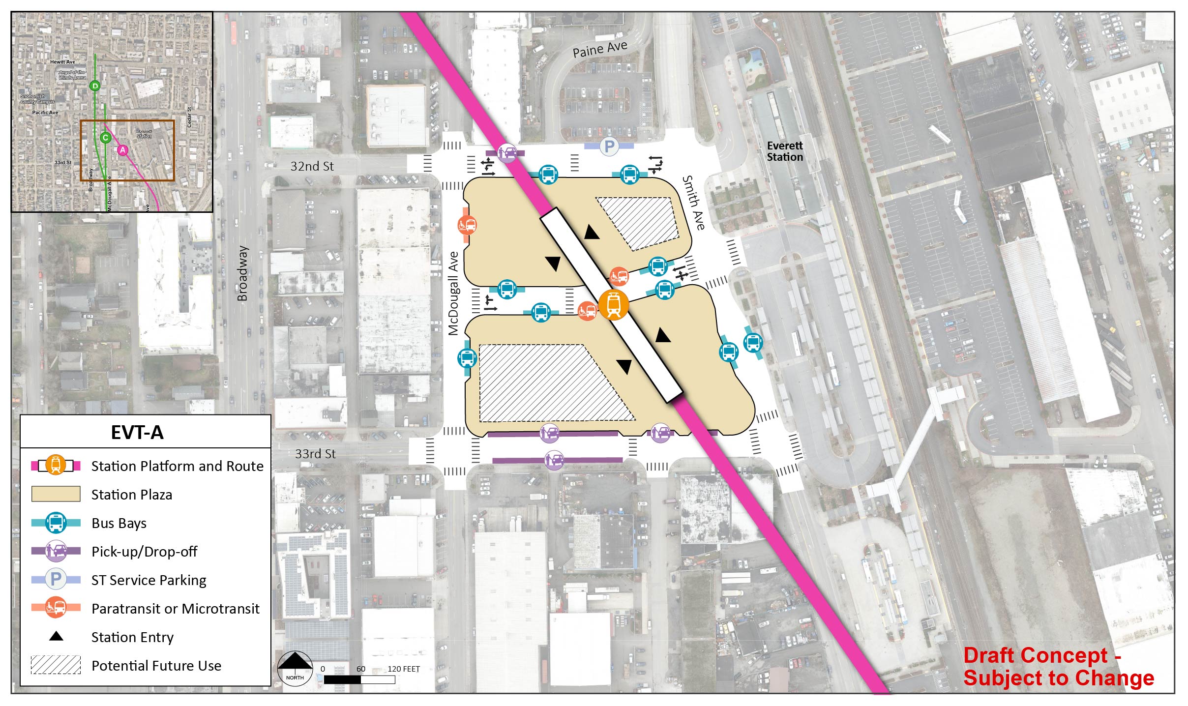
Early station layout for alternative EVT-A, an elevated station west of the existing Everett Station. | Click on image to enlarge

EVT-C

Route EVT-2 would run along McDougall and station EVT-C would be elevated about 30 feet above street level and located along McDougall just south of Pacific Avenue.

The station platform and route are in the middle of the station area for station alternative EVT-C. There are two station entry points at the north and south ends of the station. The station area and plaza extend from Pacific Avenue to 33rd Street and from Broadway to just east of McDougall Avenue. There is a lane on either side of the station platform and route with entry and exit points on Pacific Avenue and 33rddtreet. The lane on the west side of the station route two pick up/drop off spots and one paratransit/micro transit spot. The lane on the east side of the station route has four bus bays. Traffic on 32nd Street is maintained with two bus bays, one pick up/drop off spot, and one ST Service Parking spot. There is potential future use in each corner of the station area and plaza.
Early station layout for station alternative EVT-C, an elevated station located along McDougall just south of Pacific Avenue. | Click on image to enlarge

EVT-D

Route EVT-3 would run along McDougall until 34th Street and then shift west to run along Broadway. Station EVT-D would be elevated about 40 feet above street level and located along Broadway just north of Pacific Avenue.

The station platform and route are located on the west side of the station area for station alternative EVT-D. There are two station entry points at the north and south ends of the station. The station area and plaza extend from just north of Wall Street to Pacific Avenue and from Broadway to McDougall Avenue. There is a lane in the middle of the station area with entry and exit points on Pacific Avenue and 33rd Street. This lane has four bus bays and one paratransit/micro transit spot. Traffic on Wall Street is maintained with two bus bays. There are three pick up/drop off spots and one ST Service Parking spot on McDougall Avenue. There is one pick up/drop off spot at the north side of the station. There are two bus bays and one pick up/drop off spot on Broadway. There are two potential future locations on the east side of the station area and plaza.
Early station layout for station alternative EVT-D, an elevated station located along Broadway just north of Pacific Avenue. | Click on image to enlarge
 The proposed parking structures for Everett Station are shown in rectangular beige blocks that are located adjacent to the existing Everett Amtrak Station, in the area just west of Amtrak. The EVT-A and EVT-1 alternatives are both shown in pink. The EVT-1 elevated route runs north along the existing Amtrak train tracks, before ending near the existing Everett Amtrak Station. The EVT-2 and EVT-3 route alternatives, as well as the EVT-C and EVT-D station alternatives, are all shown in green, with green indicating that they are the preferred alternative. The elevated EVT-2 route runs north into downtown along the westside of McDougall Avenue before ending just north of Pacific Avenue. The EVT-3 route alternative follows the EVT-2 route’s path into downtown Everett, but veers left onto Broadway, where the route continues along the eastside of Broadway before ending north of Hewitt Avenue. The EVT-C station alternative is shown in a green circle along the EVT-2 route alternative and is located at the intersection of McDougall Avenue and 32nd Street. The EVT-D station alternative is shown in a green circle along the EVT-3 route, located at the intersection of Broadway and Wall Street.
Proposed parking facilities for Everett Station, two parking structures adjacent to the existing Everett Station, are shown above. | Click on image to enlarge

Parking

  • For this station area, one scenario for parking is being analyzed for all station alternatives.
  • Potential impacts related to parking will be assessed as part of the project’s Environmental Impact Statement.
  • Structured parking is the focus of analysis for Everett Station because it would not be possible to accommodate parking for 1,000 additional vehicles with surface parking in this station area, given the existing built environment and local code requirements.