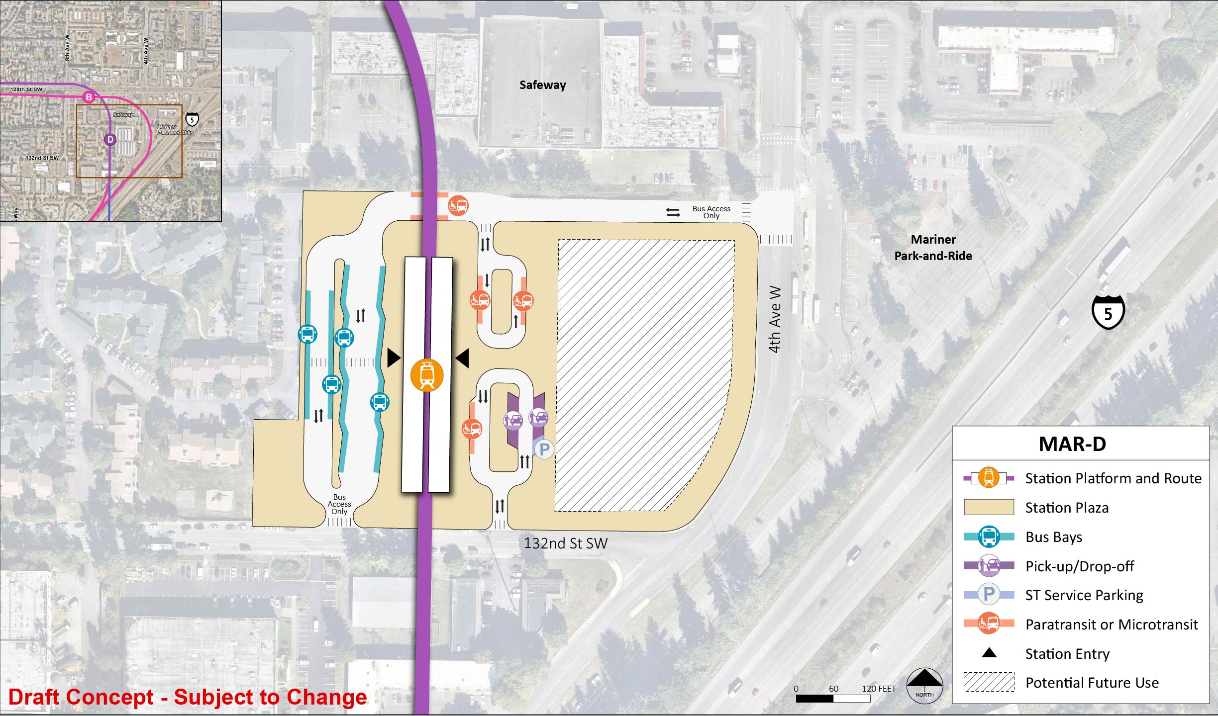
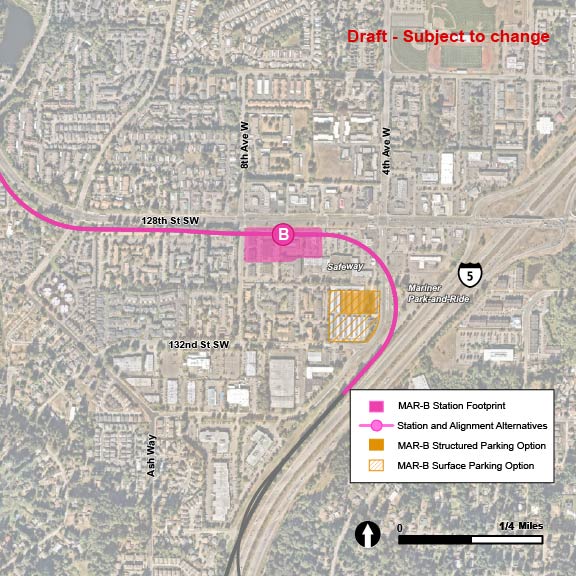
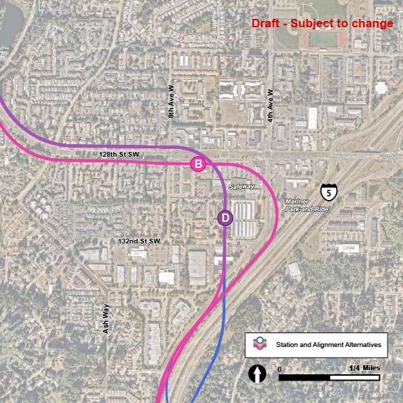
Mariner

Key features

  • All stations and routes would be elevated.
  • Community Transit serves this area with local buses and the Swift Green Line.
  • Snohomish County is actively seeking funding for a new multimodal crossing of I-5 between 130th Street SE on the east and 8th Avenue W on the west.
  • Stations in the Mariner area are larger than other station areas because it would be a major hub for local and regional buses and a light rail transfer point.
  • When Link light rail service is running to downtown Everett, two light rail lines will service the Mariner station. The station will have two platforms to accommodate the different lines, and therefore will be wider than other stations in the project.
  • The Mariner Park-and-Ride lot is west of I-5 and south of 128th Street SW.
  • Approximately 550 new parking spaces are planned at this station by 2046.
  • Potential impacts related to parking will be assessed as part of the project’s Environmental Impact Statement.
  • No preferred alternative was identified for this segment.

What has changed since 2023?

We narrowed down the number of alternatives to study in this area from three to two. You can find information about previous alternatives in the advisory group recommendations summary. We have also started evaluating parking options for this area.

The Mariner segment stretches from the Ash Way segment in the south to the State Route Ninety-Nine / Airport Road Segment in the north. The MAR-1 route alternative and the MAR-B station alternative are shown in pink, and the MAR-2 route alternative and MAR-D station alternative are shown in purple. The MAR-1 route alternative starts in an elevated route near 154th Street Southwest along the westside of Interstate 5 before a wide left turn takes the elevated route along the southside of 128th Southwest, before approaching the elevated station MAR-B at the intersection with 8th Avenue West. The MAR-1 route continues west past the MAR-B station alternative until 128th Avenue West veers northwest and turns into Airport Road. The MAR-2 route alternative starts in an elevated route near 134th Street Southwest and turns north between 4th Avenue West and 8th Avenue West before arriving at station alternative MAR-D, located adjacent to the existing Safeway parking lot and Mariner Park-and-Ride, before turning west to run along the northside of 128th Street Southwest and eventually Airport Road. MAR-B Structured Parking is indicated with a solid pink rectangle east of the Mariner Park-And-Ride. The MAR-B Surface Parking Design Option is indicated with pink hashmarks and is partially overlayed with the MAR-B Structured Parking. MAR-D Structured Parking is indicated with a solid purple triangle and the MAR-D Surface Parking Design Option is indicated with purple hashmarks.
The Mariner segment stretches from about 134th Street SW to the area south of SR 99. The route alternatives, MAR-1 and MAR-2, are pictured in pink and purple, and the station alternatives are shown as options B and D. | Click on image to enlarge
Along the MAR-1 and MAR-2 route alternatives there are two potential station alternatives: MAR-B and MAR-D. The MAR-B station alternative is located on the MAR-1 route and follows Interstate 5 north with tracks to the west of the interstate and veers left just south of 128th Street Southwest. The MAR-B station is located south of 128th Street Southwest central between 4th Avenue West and 8th Avenue West. The MAR-D station alternative is located along the MAR-2 route, which follows Interstate 5 north and veers west at 4th Avenue West. The station is located on the southside of 128th Street Southwest at the intersection of 8th Avenue West.
In this Mariner station area map, the station alternatives are shown as options B and D, and route alternatives MAR-1 and MAR-2 are pictured in pink and purple, respectively. | Click on image to enlarge

Station design elements

Below you can find early station layouts to give you an idea of what the different station alternatives may look like. These layouts are a snapshot in time and are subject to change as the design advances. As these graphics show, stations are more than just tracks and platforms. The drawings include the following station elements:

  • Pickup/drop-off: Space for personal and shared vehicles to pick up or drop off transit riders.
  • Platform: The space next to the light rail tracks where passengers wait for and move on and off trains.
  • Station entrance(s): The place where people enter or exit the Link station.
  • Potential future use: During design, a full property may be acquired by Sound Transit in order to complete construction but may not be needed for the station layout. Once construction is finished, the space could be used by Sound Transit for other project infrastructure, like stormwater ponds or electrical equipment, or developed as affordable housing or transit-oriented development projects.
  • Paratransit and microtransit: Paratransit is a transit service that provides individualized rides for people with qualifying disabilities and is supplied in accordance with the Americans with Disabilities Act. Microtransit offers an on-demand option for riders via an app, and the service is provided by vehicles smaller than a typical bus.
  • Bus bays: Designated areas for public-transit bus stops to drop off and pick up riders, providing more local connections for riders.
  • ST Service parking: Designated parking area for Sound Transit staff such as security and maintenance professionals.
  • Plaza: A public space around the station platform that includes pedestrian and bike access, connections to local bus service, and landscaping.

MAR-B

MAR-B would be located on the south side of 128th Street SW. The station would be elevated and about 60 feet above street level.

The station platform and route in the middle of the station area for station alternative MAR-B. The station entry point is between the central and east end of the platform. The station area and plaza extends to 8th Avenue West, the Safeway, and 128th Street Southwest. On 128th Street Southwest there are two bus bays. There is a lane south of the station platform and route with entry and exit points west on 8th Avenue West. There is future potential use to the south of this lane. There is another lane to the east of the station area with two pick up/drop off spots and one paratransit/micro transit spot.
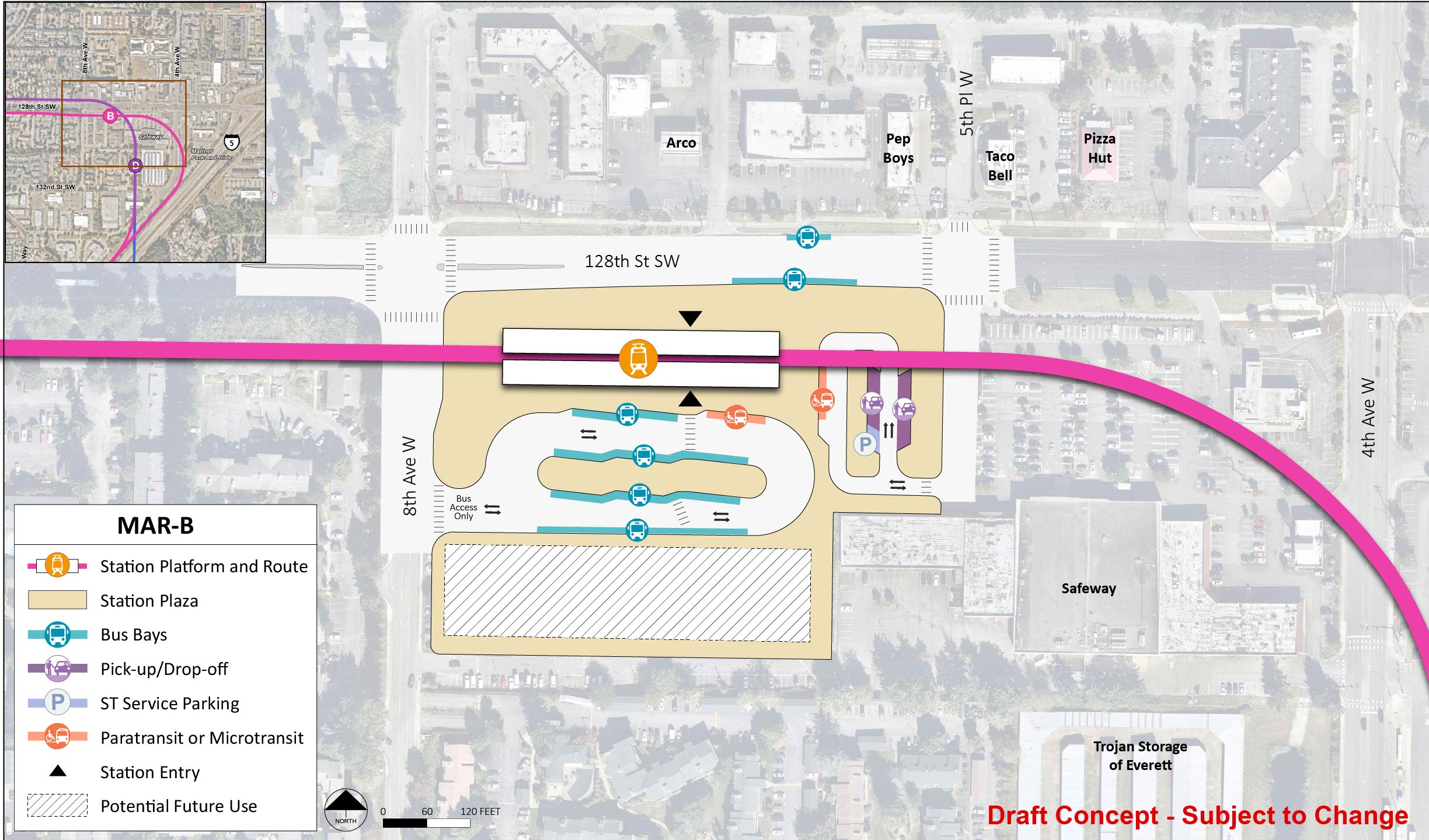
Early station layout for station alternative MAR-B, an elevated station located on the south side of 128th Street SW at the intersection with 8th Avenue W. | Click on image to enlarge

MAR-D

MAR-D station would be located between 4th Avenue W and 8th Avenue W across the street from Mariner Park-and-Ride. The station would be elevated and about 40 feet above street level.

The station platform and route are in the middle of the station area for station alternative MAR-D. The station entry point is in the middle of the platform. The station area and plaza extends to 132nd Street Southwest, the Safeway, and 4th Avenue West. There is a lane west of the station platform and route with entry and exit points at both the north and south end of the station. This lane has four bus bays. There are two lanes to the east of the station area. One lane has an entry and exit point north and has two paratransit/micro transit spots. The other lane has an entry and exit point south and has one paratransit/micro transit spot, two pick up/drop off spots, and one ST Service Parking spot. To the east of these lanes is potential future use.
Early station layout for station alternative MAR-D, an elevated station between 4th Avenue W and 8th Avenue W across the street from Mariner Park-and-Ride | Click on image to enlarge

MAR-B parking options

Proposed parking facilities, station, and light rail route for the MAR-B alternative are indicated. The MAR-B parking is shown in a pink square-shaped area stretching from 4th Ave West to the east, 132nd Street SW in the south, and stretching north to the area border Safeway. A parking structure in the northeast corner of the area is colored solid pink, while the rest of the parking facilities indicate surface parking with pink stripes. The MAR-2 route alternative is shown in pink as it runs in an elevated route along 4th Avenue West, before turning left onto the South end of 128th Avenue Southwest. The MAR-B station alternative is shown along the route, route of 128th Street Southwest and east of 8th Avenue West.
Proposed parking facilities for MAR-B, including structured parking and surface parking, near 4th Avenue W and 132nd Street SW. | Click on image to enlarge

MAR-D parking options

Proposed parking facilities, station, and route for the MAR-D alternative are both shown in purple. The MAR-D parking is shown in two triangular areas running along the westside of 4th Avenue West. The triangular areas are split by 132nd Street Southwest, and are colored by purple stripes to show they are surface parking lots. There is also structured parking planned on the eastside of 4th Avenue West, near Interstate 5. The MAR-D station alternative is shown in an area north of 132nd Street Southwest, in between the surface parking areas. The MAR-2 route alternative is shown as an elevated route as it runs north in an area between 4th Avenue West and 8th Avenue West, before turning west onto the northside of 128th Street Southwest.
Proposed parking facilities for MAR-D, including structured parking and surface parking, 4th Avenue W and 132nd Street SW. | Click on image to enlarge

Parking

  • For this station area, different concepts for parking are being analyzed for each station alternative. See maps.
  • Surface and structured parking concepts are being analyzed for both MAR-B and MAR-D, to help identify potential opportunities to deliver some additional parking before 2046, and to facilitate evaluation of tradeoffs in cost, benefits, impacts, and implications for property acquisition.