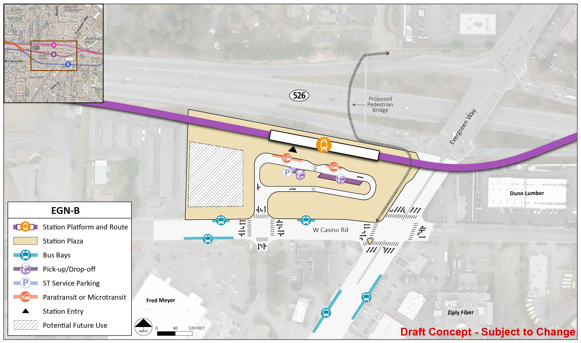
SR 526/Evergreen

Key features

  • Bus stops would be located on existing streets at all station options in this area.
  • Everett Transit and Community Transit currently serve this area with bus routes, including the Swift Blue Line.
  • No parking is included at this station as part of this project.
  • Either station EGN-A or EGN-B would require replacing the existing pedestrian bridge over SR 526.
  • No preferred alternative was identified for this segment.

What has changed since 2023?

We narrowed down the number of alternatives to study in this area from five to three. You can find information about previous alternatives in the advisory group recommendations summary. We are studying a design option that would connect route EGN-1 to station EGN-B or EGN-E if needed. We are also studying a revised connection between EGN-2 and OMF North Site B; see the OMF North alternatives’ section for more details.

The State Route 526 / Evergreen Way segment stretches from the Southwest Everett Industrial Center segment in the west to the Broadway-Interstate 5 segment in the east. The route and station alternatives are shown in different colors, with the EGN-1 route alternative and EGN-A station alternative shown in pink, the EGN-2 route alternative and EGN-B station alternative shown in purple, and the EGN-3 route alternative and EGN-E station alternative shown in blue. The EGN-1 route alternative begins in an elevated route and runs along the northside of State Route 526 before turning into a street level route as it approaches the EGN-A station alternative, which is located on the northwest corner of the intersection with Evergreen Way, before continuing east towards Interstate 5. The EGN-2 route alternative begins briefly in an elevated route on the southside of State Route 526 before turning into a street level route along Casino Road, before returning to an elevated route as it approaches the EGN-B station alternative located at the southwest intersection with Evergreen Way. Once the route passes the elevated station, the route crosses over to the northside of State Route 526. The EGN-3 route alternative takes the same street level path as the EGN-2 route on the southside of State Route 526, before turning southeast on an elevated route so it can briefly run along Casino Road and reach station alternative EGN-E, which is located on the eastern intersection of Casino Road and Evergreen Way. The elevated route continues past the EGN-E station briefly on Casino Road before turning north back onto State Route 526 along the northside of the highway.
The SR 526/Evergreen segment stretches from SW Everett Industrial Center to the Broadway/I-5 segment. Route alternatives EGN-1, EGN-2, and EGN-3 are pictured in pink, purple, and blue respectively, and the station alternatives are shown as options A, B, and E. A design option that would connect route EGN-1 to station EGN-B is shown in yellow. | Click on image to enlarge
There are three station alternatives within the State Route 526/Evergreen Way segment: EGN-A, EGN-B, and EGN-E. The EGN-A station alternative is located along the EGN-1 route, which runs along the north side of State Route 526 following the highway to the east. The EGN-A station alternative is located west of Evergreen Way and State Route 526 with the station on the north side of State Route 526. The EGN-B station alternative is located along the EGN-2 route alternative, which runs along the south side of State Route 526 following the highway to the east with the station located on the northwest corner of the Casino Road and Evergreen Way intersection. The EGN-E station is located along the EGN-3 route alternative on the southeast corner of the Casino Road and Evergreen Way intersection.
In this SR 526/Evergreen station area map, the station alternatives are shown as options A, B, and E, and route alternatives EGN-1, EGN-2, and EGN-3 are pictured in pink, purple, and blue, respectively. A design option that would connect route EGN-1 to station EGN-B or EGN-E is shown in orange. | Click on image to enlarge

Station design elements

Below you can find early station layouts to give you an idea of what the different station alternatives may look like. These layouts are a snapshot in time and are subject to change as the design advances. As these graphics show, stations are more than just tracks and platforms. The drawings include the following station elements:

  • Pickup/drop-off: Space for personal and shared vehicles to pick up or drop off transit riders.
  • Platform: The space next to the light rail tracks where passengers wait for and move on and off trains.
  • Station entrance(s): The place where people enter or exit the Link station.
  • Potential future use: During design, a full property may be acquired by Sound Transit in order to complete construction but may not be needed for the station layout. Once construction is finished, the space could be used by Sound Transit for other project infrastructure, like stormwater ponds or electrical equipment, or developed as affordable housing or transit-oriented development projects.
  • Paratransit and microtransit: Paratransit is a transit service that provides individualized rides for people with qualifying disabilities and is supplied in accordance with the Americans with Disabilities Act. Microtransit offers an on-demand option for riders via an app, and the service is provided by vehicles smaller than a typical bus.
  • Bus bays: Designated areas for public-transit bus stops to drop off and pick up riders, providing more local connections for riders.
  • ST Service parking: Designated parking area for Sound Transit staff such as security and maintenance professionals.
  • Plaza: A public space around the station platform that includes pedestrian and bike access, connections to local bus service, and landscaping.

EGN-A

Route EGN-1 would be north of SR 526 and would cross underneath Evergreen Way. The EGN-A station would be an open-air station about 30 feet below street level. The existing pedestrian bridge over SR 526 would need to be replaced if this station location is selected. A possible route for a relocated bridge is shown on the layout; due to grade requirements for new ramps, a new bridge could not be in the location of the existing bridge.

The station platform and route are located on the south end of the station area for station alternative EGN-A. The station entry point is between the middle and east end of the platform. The station area and plaza extend to State Route 526, Evergreen Way, and just west of Beverly Lane. There is a lane north of the station platform and route with entry and exit points on Beverly Lane and Evergreen Way. This lane has one paratransit/micro transit spots, two pick up/drop off spots, and one ST Service Parking spot. There are three bus bays on Evergreen Way. There is potential future use in the southwest corner of the station area and plaza.
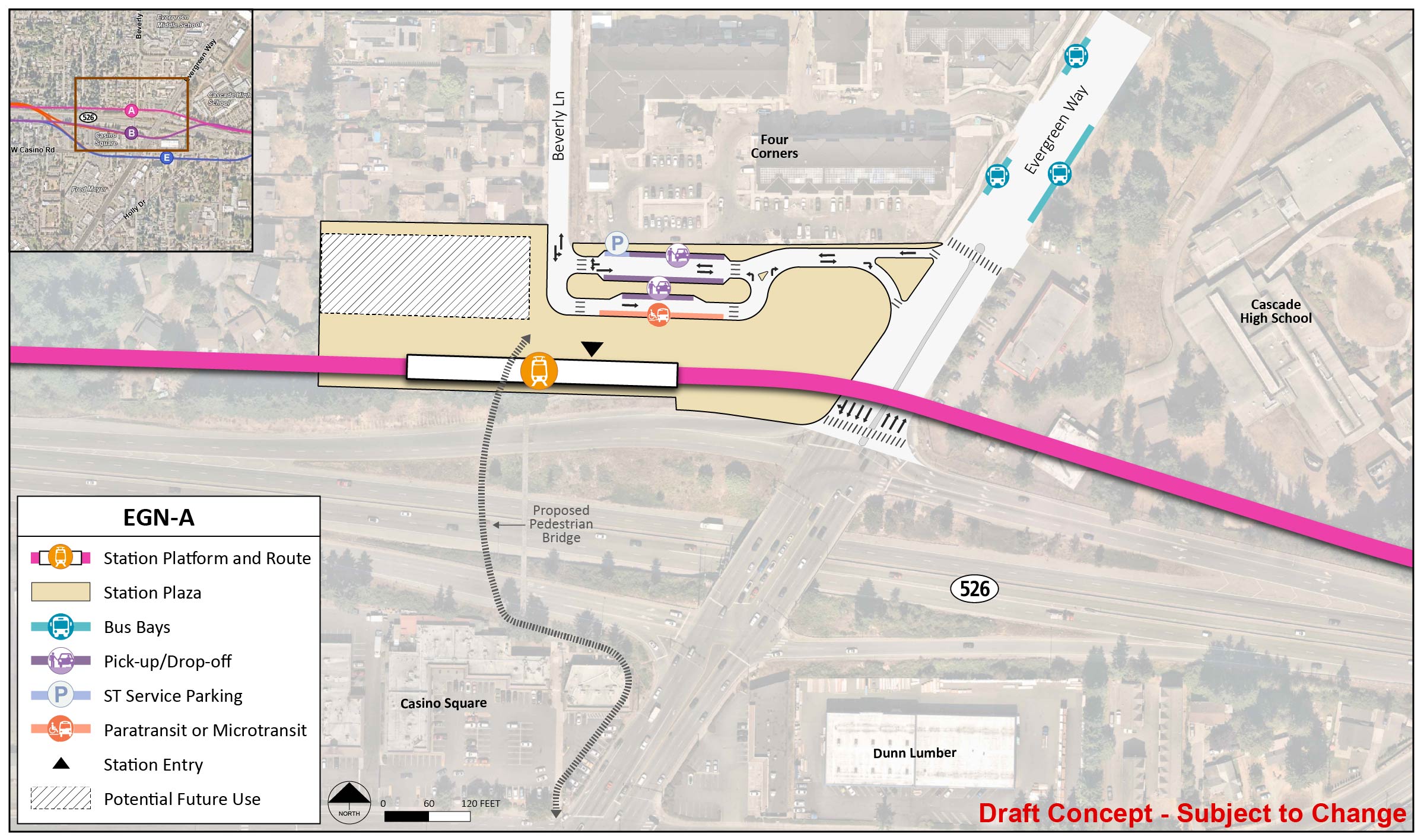
Early station layout for station alternative EGN-A, an open-air station slightly below street level located on the north side of SR 526. | Click on image to enlarge

EGN-B

Station EGN-B would be elevated about 40 feet above street level and located at the northwest corner of the Casino Road and Evergreen Way intersection. The existing pedestrian bridge over SR 526 would need to be replaced if this station location is selected. A possible route for a relocated bridge is shown on the layout; due to grade requirements for new ramps, a new bridge could not be in the location of the existing bridge.

 The station platform and route are located on the north end of the station area for station alternative EGN-B. The station entry point is between the middle and west end of the platform. The station area and plaza extend to State Route 526, Evergreen Way, and West Casino Road near the Fred Meyer. There is a lane south of the station platform and route with entry and exit points on West Casino Road. This lane has two paratransit/micro transit spots, two pick up/drop off spots, and one ST Service Parking spot. There are two bus bays on Evergreen Way and three bus bays on West Casino Road. There is potential future use in the southwest corner of the station area and plaza.
Early station layout for station alternative EGN-B, an elevated station located at the northwest corner of the Casino Road and Evergreen Way intersection. | Click on image to enlarge

EGN-E

EGN-E station would be elevated about 30 feet above street level and located at the southeast corner of the Casino Road and Evergreen Way intersection.

The station platform and route are in the middle of the station area for station alternative EGN-E. The station entry point is the middle of the platform. The station area and plaza extend to Evergreen Way, Holly Drive, and West Casino Road. There is a lane east of the station platform and route with entry and exit points on Holly Drive and West Casino Road. This lane has one paratransit/micro transit spot. There are two pick up/drop off spots on Holly Drive. There are five bus bays and three pick up/drop off locations on West Casino Road. There are two bus bays on Evergreen Way.
Early station layout for station alternative EGN-E, an elevated station located at the southeast corner of the Casino Road and Evergreen Way intersection. | Click on image to enlargee