West Alderwood
Key features
- All routes and stations would be
elevated
.
- Station alternatives are located in or around Alderwood Mall.
- Community Transit serves this area with local buses and Swift Orange Line service.
- No new parking is planned here as part of this project.
- ALD-2D was identified as the preferred alternative.
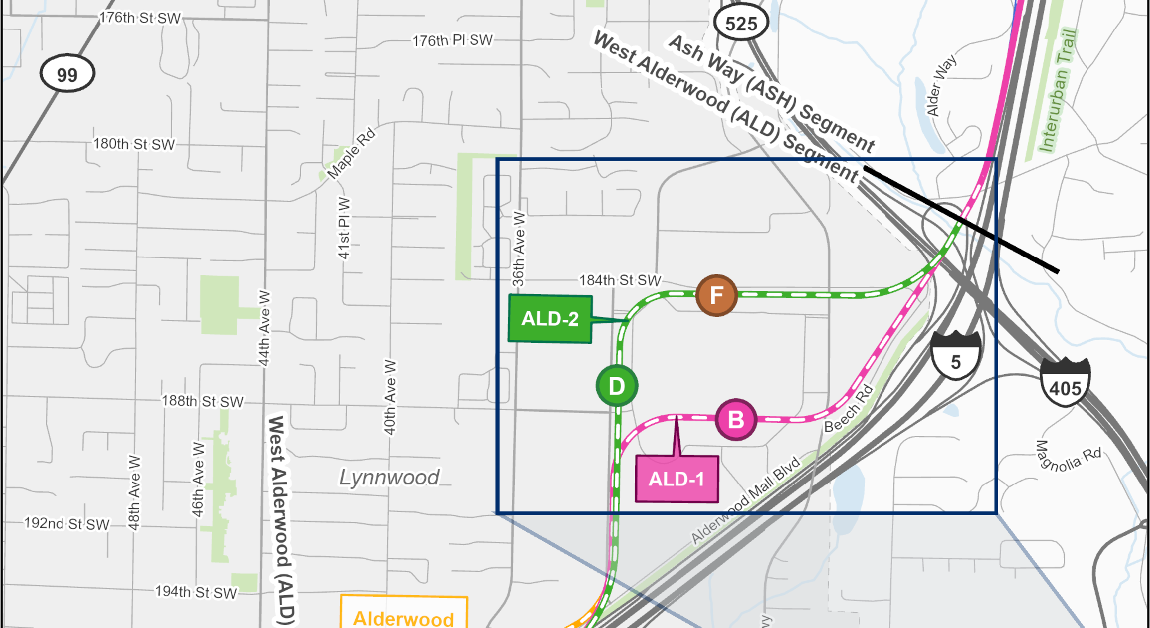 Map showing the West Alderwood segment which stretches from Lynnwood City Center to just north of the I5 / I405 / State Route 525 interchange. The preferred route alternative (ALD-2) begins at the existing light rail in Lynwood, running adjacent to I5, before turning left onto 33rd Avenue West along the west side of Alderwood Mall, and eventually turning right along 184th Street S along the north side of Alderwood Mall until it meets I5 again. There is a potential design refinement that changes the curve of the route near the interchange. Route alternative ALD1 follows the same route as ALD-2 except it runs south of the Alderwood Mall where it turns right along 188th Street S, before turning left along Beech Road. The design option for Alderwood Mall Boulevard is the same as ALD-2 but with a slight jog to the north near the State Route 524 interchange. Station alternatives ALD-D (the preferred alternative) and ALD-F are located along ALD-2. Station option alternative ALD-B is located along ALD-1.
The West Alderwood segment stretches from Lynnwood City Center Station to the I-5/I-405 interchange.
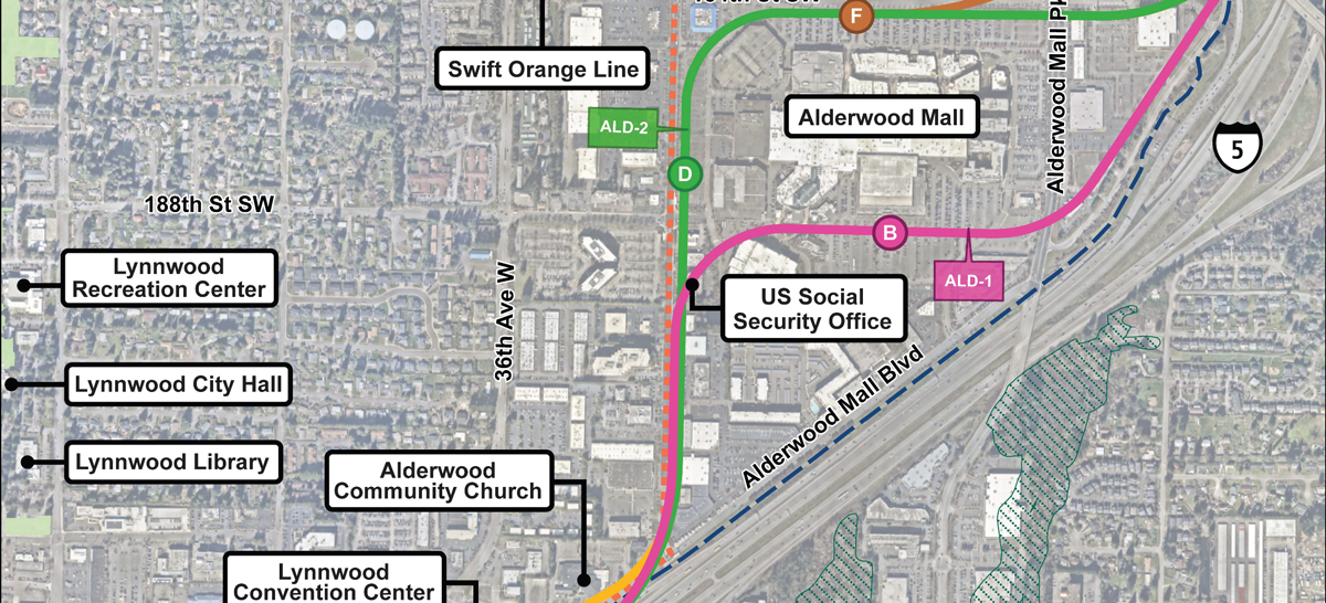 Map showing community locations and context of the surrounding neighborhood near West Alderwood station and route alternatives. Nearby locations include Alderwood Community Church, the US Social Security Office, Alderwood Mall, and wetlands are on the opposite side of I5 unaffected by any alternatives. There is a nearby transit connection to Swift Orange Line service on 33rd Avenue West running parallel to the ALD-2 route.
Community features in the West Alderwood segment shown in relation to the station and route alternatives.
Alternatives
ALD-1B (Southern Mall Alignment and Station)
Alternative ALD-1B consists of Alignment ALD-1 and Station ALD-B.
Alignment: ALD-1 would be elevated along the west side of I-5, in between the southbound travel lanes and on-ramp near the Interurban Trail, turning north near 33rd Ave W, then turning east near 188th St SW. The height of the
guideway
would range between approximately 25 and 80 feet high.
Station: ALD-B would be an elevated station on the south side of the mall near Alderwood Mall Pkwy. The station canopy would be approximately 60 feet above the ground.
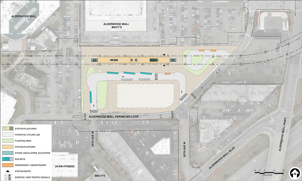 Map showing a station layout for ALD-1B located on the south side of the Alderwood Mall along the Alderwood Mall Perimeter Loop road, near Macy’s. Bus bays and space for paratransit and microtransit are located on site. There is also space for potential future use to the south.
Early station layout for station alternative ALD-B, located on the south side of Alderwood Mall within the current surface parking lot.
ALD-2D (Northern Mall Alignment with 33rd Avenue Station) – Preferred Alternative
Alternative ALD-2D consists of Alignment ALD-2 and Station ALD-D.
Alignment: ALD-2 would be elevated along the west side of I-5, in between the southbound travel lanes and on-ramp near the Interurban Trail, turning north near 33rd Ave W, then turning east near 184th St SW. The height of the guideway would range between approximately 25 and 80 feet high.
Station: ALD-D would be an elevated station on the east side of 33rd Ave W near 188th St SW on the west side of Alderwood Mall. The station canopy would be approximately 65 feet above the ground.
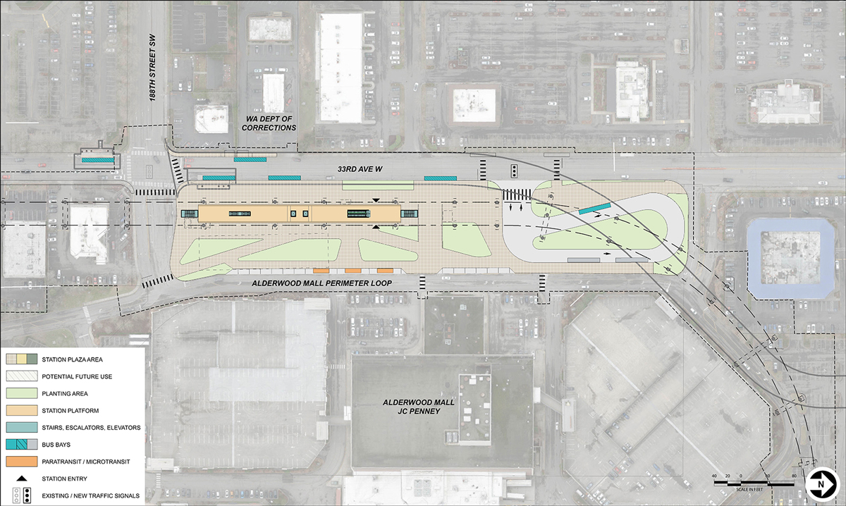 Map showing a station layout for ALD-2D, located on the west side of the Alderwood Mall, along 33rd Avenue W near JCPenney. Bus bays are located on 33rd Avenue W. Space for paratransit, microtransit, and pick-up/drop-off are located onsite to the north.
Early station layout for station alternative ALD-D, located on the west side of Alderwood Mall along 33rd Ave W.
ALD-2F (Northern Mall Alignment with 184th Street Station)
Alternative ALD-2F consists of Alignment ALD-2, described above, and Station ALD-F.
Station: ALD-F would be an elevated station on the north side of the mall in the vicinity of 184th St SW. The station canopy would be approximately 60 feet above the ground.
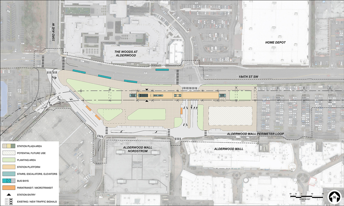 Map showing a station layout for ALD-2F located on the north side of the Alderwood Mall, near Nordstroms. Bus bays are located on 184th Street Southwest. Space for paratransit and microtransit are located along the Alderwood Mall Perimeter Loop road.
Early station layout for station alternative ALD-F, located on the north side of Alderwood Mall along 184th St SW.
Alderwood Mall Boulevard design option
The Alderwood Mall Boulevard design option would be elevated along the west side of I-5, just east of Alderwood Mall Blvd and the Interurban Trail. The alignment would then cross over to the west side of Alderwood Mall Blvd at 196th St SW. The alignment would then turn to the north to follow 33rd Ave W and continue as either Alignment ALD-1 or ALD-2 as described above.
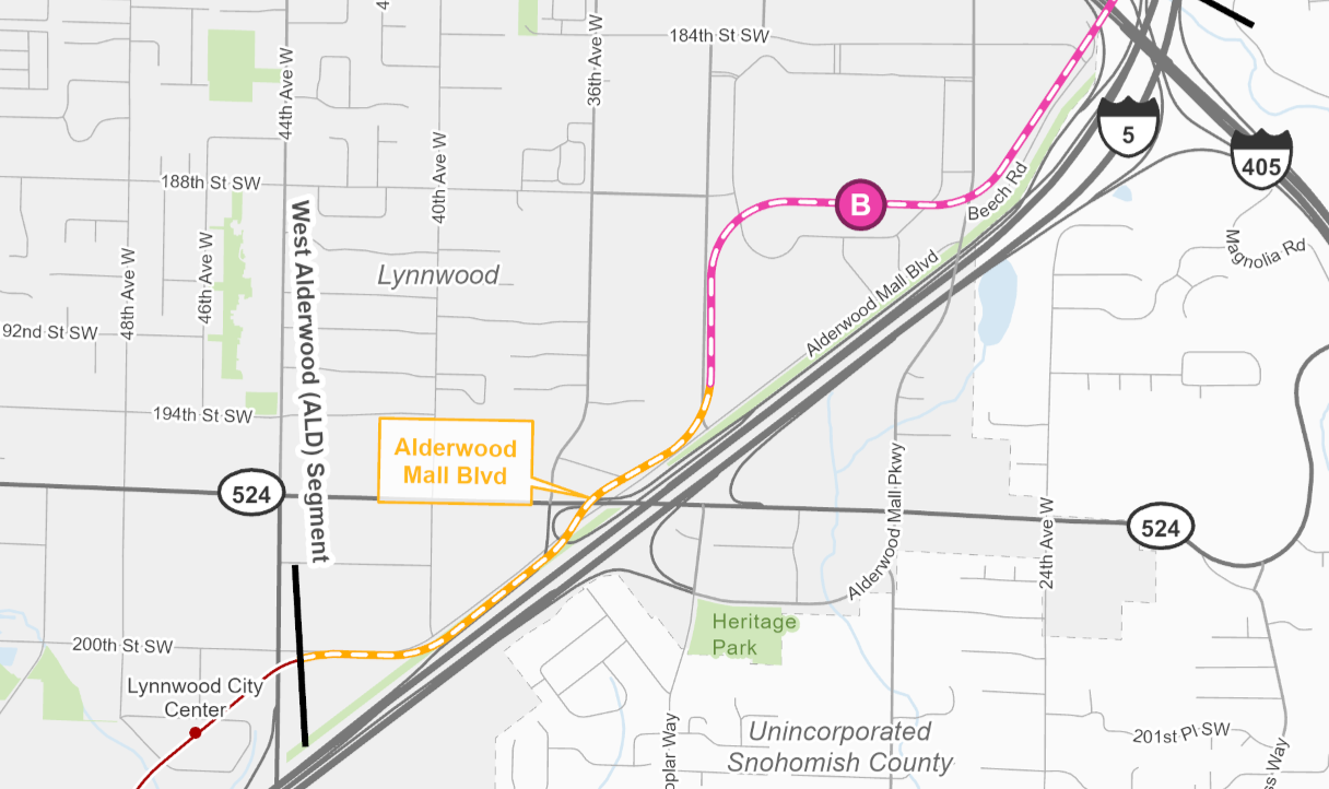 Map showing the Alderwood Mall Boulevard design option with station ALD-1B. The station is the same but the alignment would run along Alderwood Mall Boulevard instead of I5.
ALD-1B with Alderwood Mall Boulevard design option is shown above.
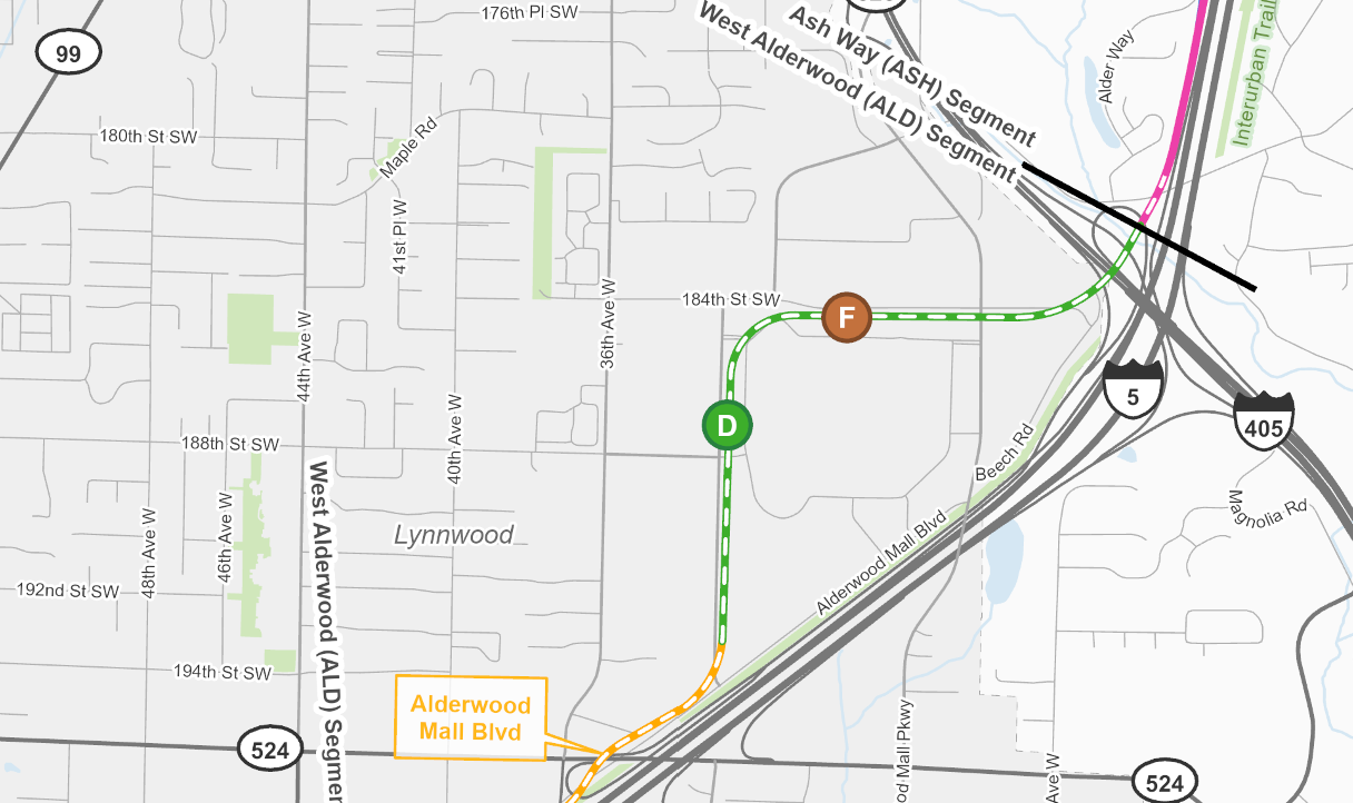 Map showing an overview of the Alderwood Mall Boulevard Design Option with preferred station ALD-D and alternative station ALD-F. The stations are the same but the alignment would run along Alderwood Mall Boulevard instead of I5.
ALD-2 with Alderwood Mall Boulevard design option is shown above, including compatibility with ALD-D and ALD-F.
Potential design refinements
- Explore shifting the guideway closer to the
public right-of-way
along 33rd Ave, potentially reducing private property impacts.
- Explore shifting the guideway near 184th St SW and Alderwood Mall Pkwy further north to potentially reduce property impacts.
A map showing alignment ALD-2 with potential design refinement.
Alternatives summary table
This table summarizes some of the key findings in the Draft EIS Executive Summary. To review the detailed summary of findings, visit Section 4.3.2.2 and Table 4-3 of the Draft EIS.
Summary of potential effects – West Alderwood Segment
Notes:
a) Numbers or descriptions presented in this table are for permanent or long-term impacts, except where a construction impact is noted.
b) Opinions of probable cost are in 2025 dollars, are for comparative purposes only, and do not represent the project budget.
Please note that the information contained in the table is repeated in an outlined list below. There is no difference from the content shared in the table. It is provided in two different formats so the information is accessible to everyone.
The summary of impacts is organized by Resource Impact Measure.
Potential street closures during construction
- All alternatives: Overnight closures of access ramps to/from I-5, I-405, and SR 525.
Number of potential residential displacements
Number of potential business displacements
- ALD-1B and ALD-1B with Alderwood Mall Boulevard design option: 14.
- ALD-2D: 37.
- ALD-2D with Alderwood Mall Boulevard design option: 36.
- ALD-2F: 29.
- ALD-2F with Alderwood Mall Boulevard design option: 28.
Displaced social resources/community facilities
- ALD-1B, ALD-1B with Alderwood Mall Boulevard design option, ALD-2D, ALD-2D with Alderwood Mall Boulevard design option:
- US Social Security office.
- ALD-2F, ALD-2F with Alderwood Mall Boulevard design option: None
Ecosystem impact
- All alternatives: No impacts to wetlands, 50 linear feet of streams, no impacts to open space upland habitats.
Number of historic properties with potential adverse effects
- ALD-1B, ALD-1B with Alderwood Mall Boulevard design option: 1.
- ALD-2D, ALD-2D with Alderwood Mall Boulevard design option, ALD-2F, ALD-2F with Alderwood Mall Boulevard design option: 2.
Opinion of probable cost in millions
- ALD-1B: $960 – 1,090.
- ALD-1B with Alderwood Mall Boulevard design option: $930 – 1,050.
- ALD-2D: $990 – 1,110.
- ALD-2D with Alderwood Mall Boulevard design option: $960 – 1,080.
- ALD-2F: $950 – 1,070.
- ALD-2F with Alderwood Mall Boulevard design option: $920 – 1,040.
To leave a comment on the Draft EIS or the project alternatives, please fill out our Draft EIS comment form/survey. You can also learn more about what type of comments we’re looking for, how to comment, and where to comment on the Comment now page.
