OMF North
Key features
- Requires 80 to 100+ acres for the new Operations and Maintenance Facility (OMF) North. This includes approximately 50 to 70 acres for the completed site and up to 30 acres for additional construction and potential mitigation needs.
- Supports planned Sound Transit light rail expansion critical for keeping the system safe and clean.
- Designed to maintain, store, and deploy 150+ light rail vehicles, with additional maintenance facility space for equipment and service vehicles.
- Provides mainline track, systems, and station maintenance functions (Maintenance of Way).
- Expected to support 450+ high-skilled, living-wage jobs in Snohomish County. The average employee wage is currently more than $45 per hour, or $85,000/year, at our existing OMF facilities.
- To be designed to meet Sound Transit sustainability goal: Leadership in Energy and Environmental Design (LEED) Gold.
- No preferred alternative was identified for OMF North.
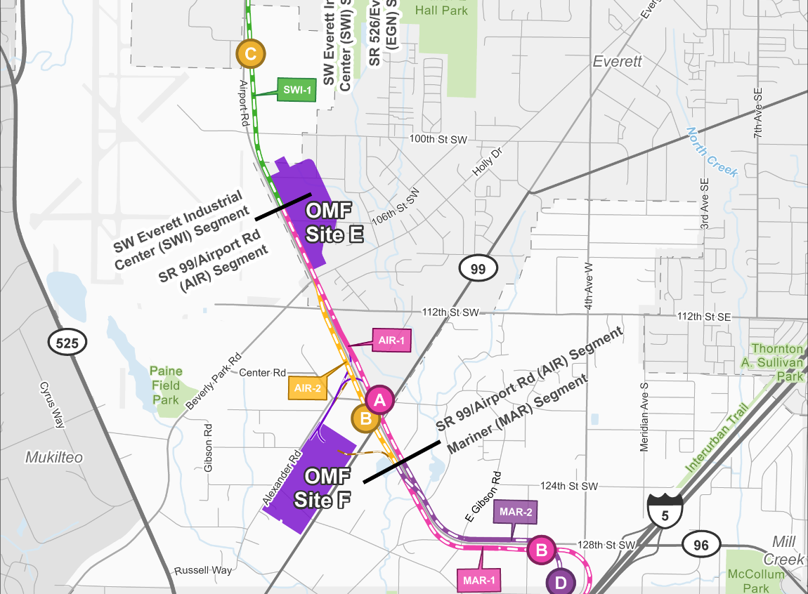 Map showing the 3 Operations and Maintenance Facility alternatives: OMF Site B, OMF Site E, and OMF Site F. OMF Site B is the northernmost alternative and is located north of State Route 526 between the Southwest Everett Industrial Center and Evergreen stations. OMF Site E is located near Paine Field, east of Airport Road and South of 100th Street Southwest. OMF Site F is the southernmost alternative, located south of Airport Road and west of Evergreen Way.
There are three OMF North site alternatives we're studying. Two of the site alternatives also have a design option being considered.
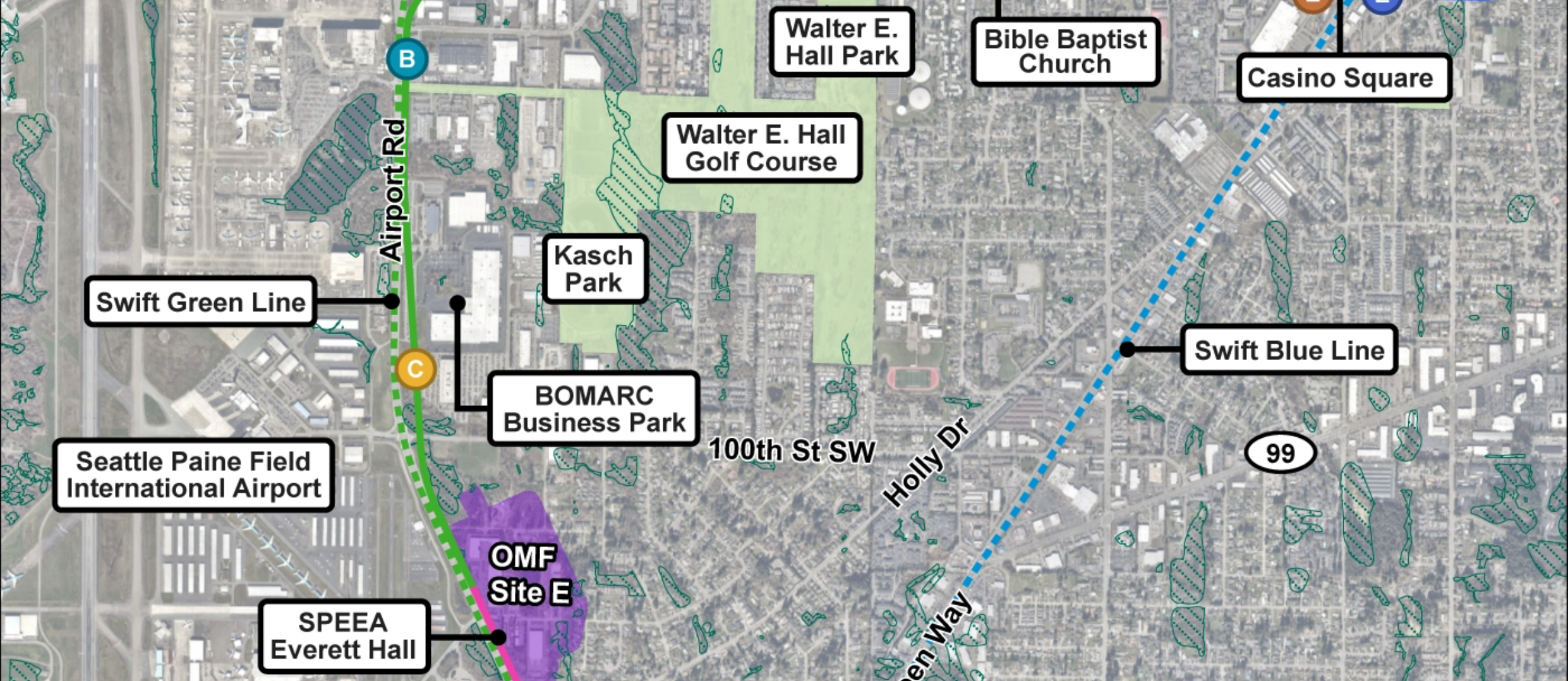 Map showing community locations and context of the surrounding neighborhood near the three OMF North locations. Key landmarks are Paine Field Airport, Walter E. Hall Park, Kasch Park, and Boeing Everett Production Facility.
Community features shown in relation to the OMF North alternatives.
Alternatives
OMF Site B (SR 526)
OMF Site B would be an approximately 66-acre site located in the city of Everett between SR 526 and 75th St SW, east of 16th Ave W. The
lead tracks
for this site would be at- or above-grade, connecting to the
mainline
on the north side of SR 526. The maximum height of OMF structures, including maintenance and maintenance of way (MOW) buildings, would be two stories. This site is compatible with Alignment EGN-1 and the North Side of SR 526 Design Options for Alignments EGN-2 and EGN-3.
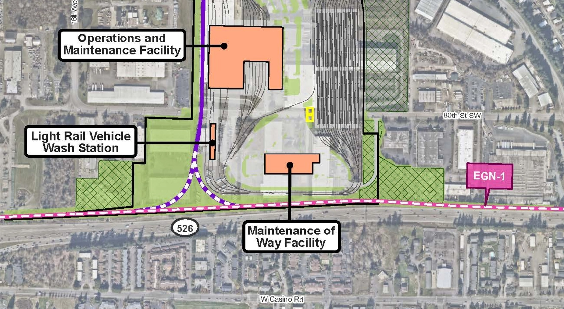 Map showing how route alternative EGN-1 would connect to Site B. The site has 3 buildings including a vehicle wash station and many yard tracks.
A map of OMF Site B showing lead tracks on the north side of SR 526.
OMF Site B with lead tracks to south side of SR 526 design option
The Lead Tracks to South Side of SR 526 Design Option would be on the same site as OMF Site B though with a smaller size (approximately 59 acres). The lead tracks for this site would be at-grade on the south side of SR 526, crossing over SR 526 near 10th Ave W. The maximum height of OMF structures, including maintenance and MOW buildings, would be two stories. This lead track design option is compatible with Alignments EGN-2 and EGN-3.
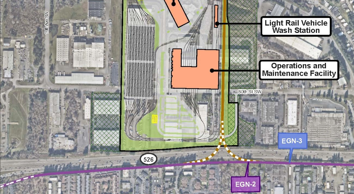 Map showing how route alternative EGN-2 or EGN-3 would connect to Site B. The site has 3 buildings including a vehicle wash station and many yard tracks.
A map of OMF Site B showing the design option with lead tracks on the south side of SR 526.
OMF Site E (Airport Road)
OMF Site E would be an approximately 53-acre site along the east side of the alignments in the SR 99/Airport Road and SW Everett Industrial Segments, primarily within the city of Everett and unincorporated Snohomish County. The site would be north of Holly Drive, east of Airport Road, west of 21st Ave W, and south of 100th St SW. For this OMF site, the lead tracks and a portion of the mainline alignment between Holly Dr and 100th St SW would be at-grade. The maximum height of OMF structures, including maintenance and MOW buildings, would be two stories. This site is compatible with all alignment alternatives.
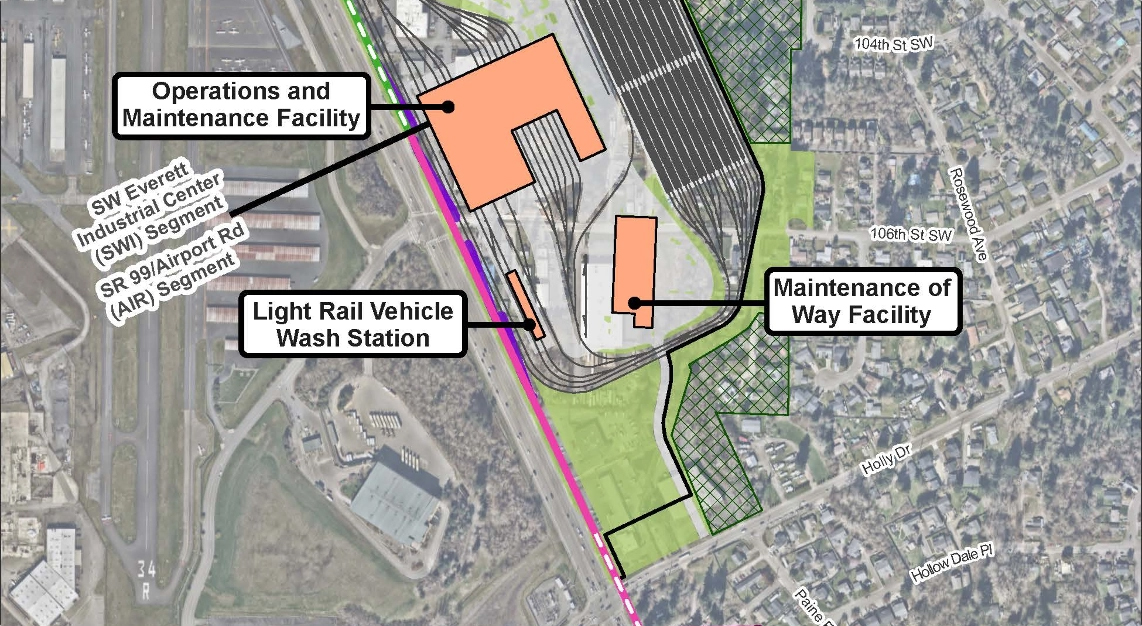 Map showing how route alternatives AIR-1 and SWI-1 would connect to Site E. The site has 3 buildings including a vehicle wash station and many yard tracks.
A map of OMF Site E.
OMF Site F (SR 99)
OMF Site F would be an approximately 59-acre site along the southwest side of the alignments in the SR 99/Airport Road Segment within unincorporated Snohomish County. The site would be southwest of Airport Road, northwest of SR 99, and southeast of Alexander Road. The lead tracks for this site would cross over Airport Road to connect to Alignment AIR-1 at approximately 65 feet above grade and come down to enter the facility at-grade. The maximum height of OMF structures, including maintenance and MOW buildings, would be two stories. This site is compatible with Alignment AIR-1.
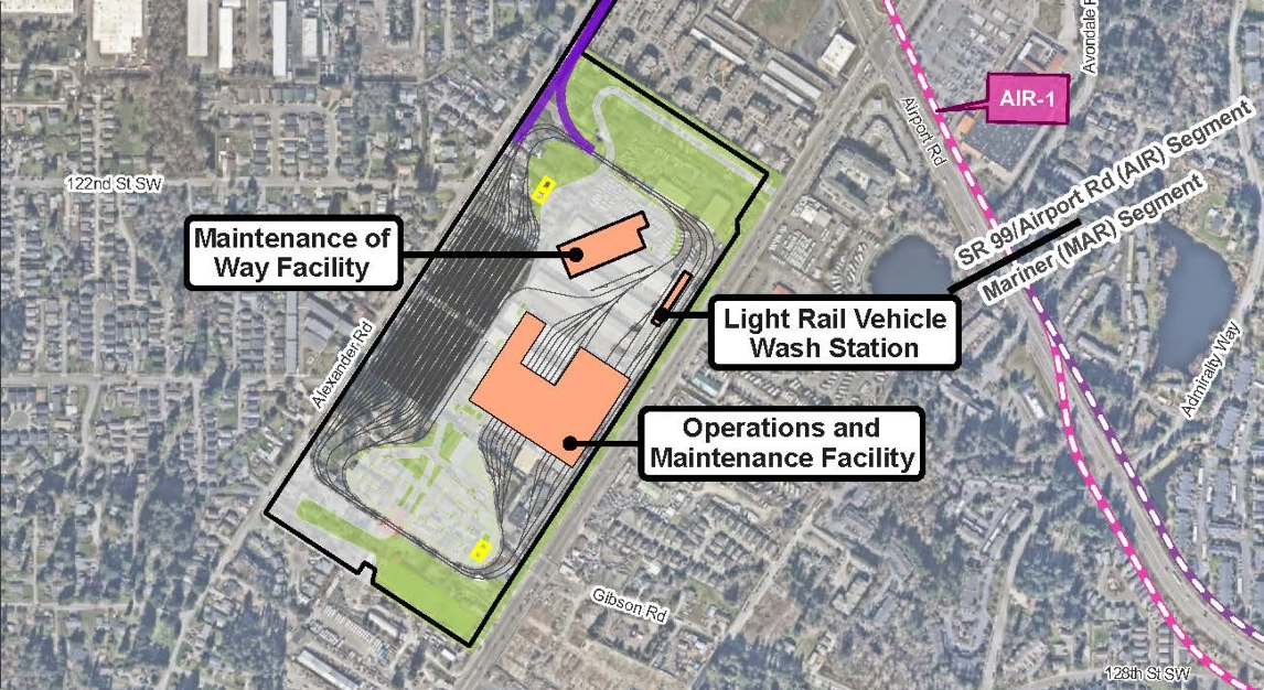 Map showing how route alternative AIR-1 would connect to Site F. The site has 3 buildings including a vehicle wash station and many yard tracks.
A map of OMF Site F showing lead tracks that cross over Airport Road.
OMF Site F with lead tracks to west side of Airport Road design option
The Lead Tracks to West Side of Airport Road Design Option would be on the same site and have the same layout as OMF Site F. The lead tracks for this site would be elevated on the west side of Airport Road north and south of Evergreen Way. The maximum height of OMF structures, including maintenance and MOW buildings, would be two stories. This lead track design option is compatible with Alignment AIR-2.
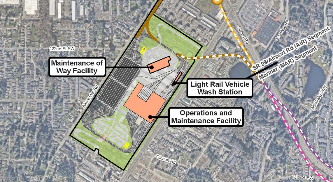 Map showing how route alternative AIR-2 would connect to Site F. The site has 3 buildings including a vehicle wash station and many yard tracks.
A map of OMF Site F showing the design option with lead tracks on the west side of Airport Road.
Alternatives summary table
This table summarizes some of the key findings in the Draft EIS Executive Summary. To review the detailed summary of findings, visit Section 4.3.2.10 and Table 4-109 of the Draft EIS.
Summary of potential effects – OMF North Segment
Notes:
a) Numbers or descriptions presented in this table are for permanent or long-term impacts, except where a construction impact is noted.
b) Opinions of probable cost are in 2025 dollars, are for comparative purposes only, and do not represent the project budget.
Please note that the information contained in the table is repeated in an outlined list below. There is no difference from the content shared in the table. It is provided in two different formats so the information is accessible to everyone.
The summary of impacts is organized by Resource Impact Measure.
Potential street closures during construction
- OMF Site F, OMF Site E, and OMF Site B: No interstate or state highway closures.
- OMF Site F with lead tracks to west side of Airport Road design option: Overnight closures of SR 99.
- OMF Site B with lead tracks to south side of SR 526 design option: Overnight closures of SR 526.
Number of potential residential displacements
- OMF Site F and OMF Site F with lead tracks to west side of Airport Road design option: 186.
- OMF Site E: 49. OMF Site B: None.
- OMF Site B with lead tracks to south side of SR 526 design option: 90.
Number of potential business displacements
- OMF Site F: 68.
- OMF Site F with lead tracks to west side of Airport Road design option: 62.
- OMF Site E: 13.
- OMF Site B: 16.
- OMF Site B with lead tracks to south side of SR 526 design option: 13.
Displaced social resources/community facilities
- OMF Site F and OMF Site F with lead tracks to west side of Airport Road design option: Airport RV Park and two multi-unit buildings at the Axis Apartment complex, a HUD-assisted apartment complex.
- OMF Site E: Aerospace Machinist District 751 and Society of Professional Engineering Employees in Aerospace (SPEEA) Everett Hall.
- OMF Site B and OMF Site B with lead tracks to south side of SR 526 design option: None.
Ecosystems impacts
- OMF Site F: 0.3 acres of wetlands, 100 linear feet of streams, and 0.5 acres of open space upland habitats.
- OMF Site F with lead tracks to west side of Airport Road design option: 1.2 acres of wetlands, no impacts to streams, 1 acre of open space upland habitats.
- OMF Site E: 5.2 acres of wetlands, 850 linear feet of streams, and 19.7 acres of open space upland habitats.
- OMF Site B: 1.1 acres of wetlands, 1,950 linear feet of streams, and 2.9 acres of open space upland habitats.
- OMF Site B with lead tracks to south side of SR 526 design option: 1.3 acres of wetlands, 2,650 linear feet of streams, and 2.9 acres of open space upland habitats.
Number of historic properties with potential adverse effects
- OMF Site F and OMF Site F with lead tracks to west side of Airport Road design option: 11 (1 individually eligible property and 1 eligible historic district with 10 contributing resources).
- OMF Site E, OMF Site B, and OMF Site B with lead tracks to south side of SR 526 design option: None.
Opinion of probable cost in millions
- OMF Site F: $2.03 – 2.28.
- OMF Site F with lead tracks to west side of Airport Road design option: $2.11 – 2.38.
- OMF Site E: $1.72 – 1.94.
- OMF site B: $2.31 – 2.60.
- OMF Site B with lead tracks to south side of SR 526 design option: $2.31 – 2.61.
To leave a comment on the Draft EIS or the project alternatives, please fill out our Draft EIS comment form/survey. You can also learn more about what type of comments we’re looking for, how to comment, and where to comment on the Comment now page.
