Everett Link Extention
Welcome
Explore the latest
The Everett Link Extension is an ambitious mass transit system expansion that will extend Link light rail service north from Lynnwood City Center to the Everett Station area. This project will also include the Operations and Maintenance Facility (OMF) North, a necessary facility to support Link light rail operations.
Everett Link is currently in the planning phase. In June 2023, the Sound Transit Board identified alternatives for stations, routes, and OMF North locations for study during the environmental review process. In June 2024, we shared early station layouts to help illustrate what future stations could look like.
About this site
This site provides information on:
 Subscribe for project news
Chat with us!
We'll be at several community events in the next few months and would be happy to talk to you about the project. See the calendar of upcoming events.
Learn more
- Everett Link Extension website
- Fact sheet [English] [Korean] [Russian] [Spanish]
- Community Engagement Guide
- Community Engagement fact sheet [English] [Korean] [Russian] [Spanish]
- Frequently asked questions [English] [Korean] [Russian] [Spanish]
- Project schedule
- Property Owner Guide [English] [Korean] [Russian] [Spanish]
Background
About the project
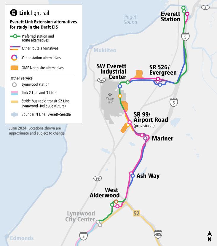
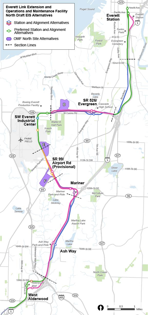
The Everett Link Extension will provide fast, reliable connections to residential and employment centers throughout the region. We’re planning to add approximately 16 miles of light rail and six new stations connecting Snohomish County residents to the regional Link light rail network. In addition, we are studying a provisional (unfunded) station through the planning process as well as parking facilities at two station locations.
The project includes the essential OMF North, which would support overall system operation and have the capacity to receive, store, and service a larger train fleet to support Link extensions. To build this new facility, we need approximately 80-100+ acres near the light rail line.
What we've done so far:
As part of the ST3 ballot measure in 2016, voters approved funding for the representative project, which established light rail as the transit mode for the corridor, an approximate route, the number and general locations of light rail stations, and passenger access. The representative project was our starting point for project planning.
The first step in planning was alternatives development, where we worked with the Federal Transit Administration, local jurisdictions, and communities to identify any additional alternative routes, stations, and OMF North locations to be studied alongside the representative project in the environmental review process.
During alternatives development, we evaluated potential alternatives at progressively greater levels of detail and invited comments from the public, Tribes, and agencies at each level. We provided updates and asked for feedback on alternatives at three major decision-making points:
- Early scoping period in November – December 2021.
- Level 1 analysis in March – April 2022.
- EIS scoping period in January – March 2023.
Your feedback supported our advisory groups' efforts to narrow down the number of alternatives and ultimately helped Sound Transit identify which alternatives would be studied in the Environmental Impact Statement (EIS).
In June 2023, the Sound Transit Board identified alternatives, including some preferred alternatives, for stations, routes, and OMF North locations to be studied in the EIS. This was the final step in the alternatives development phase of the project, and from there we transitioned into the environmental review phase, which will last for the next several years.
In summer 2024, Sound Transit shared updated station area maps, early station layouts, and updated OMF North maps. Although this was not an official comment period, viewers were able to leave feedback through a comment form on the site.
Through the Nonmotorized Station Access Allowance Program, Sound Transit works with jurisdiction partners to create safe and direct walking, biking, and rolling routes to the Everett Link stations from neighborhoods, businesses, and community gathering spaces. In May 2025, we shared our initial list of candidate projects and asked for community feedback to help us understand how you will get to future Everett Link stations.
When will decisions about locations be made?
The Sound Transit Board will make their official decision about which route and stations and which OMF North location to build after environmental review is complete, which we expect to happen in or around 2027. Learn more in Next steps.
Project area
Environmental review
What is an EIS?
The project is currently in the environmental review phase, which includes preparing an Environmental Impact Statement. The EIS evaluates the potential adverse or beneficial effects of each alternative to the physical, human, and natural environment and also proposes measures to avoid, minimize, or mitigate significant adverse effects where appropriate.
The EIS will be published in two documents: a Draft EIS and a Final EIS. The Draft EIS will be available for public review and comment for at least 45 days. The Final EIS will address public, Tribe, and agency comments; will include any necessary revisions to correct technical errors; and will add any new information that became available since the Draft EIS was published.
This EIS will be prepared in compliance with both the National Environmental Policy Act (NEPA) and the Washington State Environmental Policy Act (SEPA). The Federal Transit Administration is anticipated to be the lead agency under NEPA, and Sound Transit is the lead agency under SEPA. Sound Transit conducted public scoping under SEPA in 2023 to begin work on the Draft EIS, and the FTA is expected to conduct a second public scoping process on the Draft EIS under NEPA in mid-2025. Decisions that were made by Sound Transit in the local SEPA scoping process may be revisited in the subsequent federal NEPA process.
Preparing the Draft EIS
The Draft EIS will describe how the alternatives might affect the natural and built environments during both construction and future operations. We are conducting a detailed evaluation including identifying potential property acquisitions, conducting fieldwork, and working with local jurisdictions to coordinate with their planning processes. Our current timeline estimates that the Draft EIS will be ready for public review in early 2026.
We’ll prepare informational materials to explain key findings from the Draft EIS that will help you compare the alternatives. During the comment period, we’ll ask you for feedback on the Draft EIS. Your input is a key part of the environmental review process and will help the Sound Transit Board understand what is important to you as they identify a preferred alternative for the Final EIS.
The EIS will comply with all applicable environmental laws, regulations, and executive orders relevant to the proposed project. Sound Transit proposes to address the following topics within the EIS:
- Acquisitions, displacements, and relocations.
- Air quality, including greenhouse gas emissions.
- Economics.
- Ecosystems.
- Electromagnetic fields.
- Energy.
- Environmental justice.
- Geology and soils.
- Hazardous materials.
- Historic, cultural, and archeological resources including Section 106 (National Historic Preservation Act) resources and process.
- Land use.
- Noise and vibration.
- Parks and recreational resources.
- Public services, safety, and security.
- Section 4(f) of U.S. Department of Transportation Act and Section 6(f) of the Land and Water Conservation Fund Act.
- Social resources, community facilities, and neighborhoods.
- Transportation (traffic, freight, navigation, transit, non-motorized).
- Utilities.
- Visual and aesthetic resources.
- Water resources.
In evaluating these topics, the EIS will address direct, indirect, and cumulative effects of both the construction and the operation of the project and will propose measures to avoid, minimize, or mitigate significant adverse effects where needed, to inform decision makers, the public, Tribes, and agencies about the project. Learn more about NEPA regulations.
The purpose of the Everett Link Extension is to expand the Link light rail system from the Lynnwood City Center Link Station to the Everett Station area and provide an OMF in order to:
- Provide high quality, rapid, reliable, accessible, and efficient light rail transit service to communities in the project corridor as defined through the local planning process and reflected in the ST3 Plan.
- Improve regional mobility by increasing connectivity and capacity in the Everett Link Extension corridor from the Lynnwood Transit Center to the Everett Station area to meet projected transit demand.
- Connect regional centers as described in adopted regional and local land use, transportation and economic development plans, and Sound Transit’s Regional Transit Long-Range Plan.
- Implement a system that is technically and financially feasible to build, operate, and maintain.
- Expand mobility for the corridor and region’s residents, including explicit consideration for transit-dependent, low-income, and minority populations.
- Encourage equitable and sustainable growth in station areas through support of transit-oriented development and multimodal integration in a manner that is consistent with local land use plans and policies, including Sound Transit’s Equitable Transit-Oriented Development Policy and Sustainability Plan.
- Encourage convenient, safe, and equitable non-motorized access to stations, such as bicycle and pedestrian connections, consistent with Sound Transit’s System Access Policy and Equity and Inclusion Policy.
- Preserve and promote a healthy environment and economy by minimizing adverse effects on the natural, built, and social environments through sustainable and equitable practices.
- Provide an operations and maintenance facility with the capacity to receive, test, commission, store, maintain, and deploy vehicles to support the intended level of service for system-wide light rail system expansion.
- Develop an operations and maintenance facility that supports efficient and reliable light rail service and minimizes system operating costs.
The project is needed because:
- Chronic roadway congestion on Interstate 5 and State Route 99 – two primary highways connecting communities along the corridor – delays today’s travelers, including those using transit, and degrades the reliability of bus service traversing the corridor, particularly during commute hours.
- These chronic, degraded conditions are expected to continue to worsen as the region’s population and employment grow.
- Puget Sound Regional Council (the regional metropolitan planning organization) and local plans call for high-capacity transit in the corridor consistent with Puget Sound Regional Council’s VISION 2050 and Sound Transit’s Regional Transit Long-Range Plan.
- Snohomish County residents and communities, including transit-dependent residents and low-income or minority populations, need long-term regional mobility and multimodal connectivity, as called for in the Washington State Growth Management Act.
- Regional and local plans call for increased residential and/or employment density at and around high-capacity stations and increased options for multimodal access.
- Environmental and sustainability goals of the state and region, as established in Washington state law and embodied in Puget Sound Regional Council’s VISION 2050 and Regional Transportation Plan, include reducing greenhouse gas emissions by prioritizing transportation investments that decrease the vehicle miles traveled.
- The current regional system lacks an operations and maintenance facility with sufficient capacity and suitable location to support the efficient and reliable long-term operations for system-wide light rail expansion, including the next phase of light rail expansion in Snohomish and King Counties.
- New light rail maintenance and storage capacity needs to be available with sufficient time to accept delivery of and commission new vehicles to meet fleet expansion needs and to store existing vehicles while new vehicles are tested and prepared.
What is fieldwork?
Sound Transit is currently studying the corridor by collecting and analyzing information to use for the Draft EIS. Fieldwork is necessary to further design and study light rail alignments, stations, and OMF North alternatives. Fieldwork crews perform various activities such as geotechnical drilling, archeological investigations, and civil engineering surveys.
Tribal engagement
To uphold our commitment to lifting Tribal voices in our region, we are partnering with Tribes as they participate in the identification, analysis, and evaluation of the Everett Link Extension alternatives. We have reached out to the following Tribes and will continue to collaborate with them for the duration of the project:
- Confederated Tribes and Bands of the Yakama Nation.
- Confederated Tribes of the Warm Springs Reservation of Oregon.
- Muckleshoot Indian Tribe.
- Port Gamble S’Klallam Tribe.
- Sauk-Suiattle Indian Tribe.
- Snoqualmie Indian Tribe.
- Stillaguamish Tribe of Indians of Washington.
- Suquamish Indian Tribe of the Port Madison Reservation.
- Swinomish Indian Tribal Community.
- Tulalip Tribes of Washington.
- Upper Skagit Indian Tribe.
- Duwamish Tribal Organization.*
- Snohomish Tribe of Indians.*
* Non-federally recognized.
The Federal Transit Administration will also consult with federally recognized Tribes when they begin their NEPA work.
Alternatives
Which routes, stations, and OMF North locations are being studied in environmental review?
Linked below are the latest design concepts for the route, station, and OMF North alternatives being studied in the Draft EIS. All alternatives shown on this site will be studied over the next several years and design will continue to advance. When Sound Transit starts preparation of a Final EIS, a preferred alternative will be identified for all project components. Sound Transit will select the final locations for the route, stations, and OMF North after completion of the environmental review process under both SEPA and NEPA.
How has community input influenced the project?
During scoping in early 2023, we asked you which alternatives you preferred and why. Thanks to your input, we narrowed down the station and route alternatives and identified preferred alternatives in four out of eight project segments.
The project team has also advanced the design of route, station, and OMF North alternatives to incorporate some of the feedback we heard during scoping. Any changes made since we last shared information are explained in each area.
How to view project segments and OMF North updates
You can learn more about the project areas by clicking the name below. From there, you can learn about specific alternatives and see the latest segment maps, early station layouts, and OMF North locations.
Project overview map
Next steps
Through 2025, we will continue to advance conceptual engineering, station designs, and environmental review. While our team is doing this work, there will be times when we need your input — see below — and you are always welcome to contact us with any questions or comments! Our team will consider public input as we continue to develop the project alternatives in greater detail.
Opportunities for input
We expect to coordinate with the Federal Transit Administration as they conduct NEPA scoping in 2025, which includes a formal opportunity for public input.
We also expect to publish the Draft EIS in early 2026. There will be multiple ways to provide input during a formal comment period, including through this engagement website and public meetings where you can learn more about the project.
Timeline
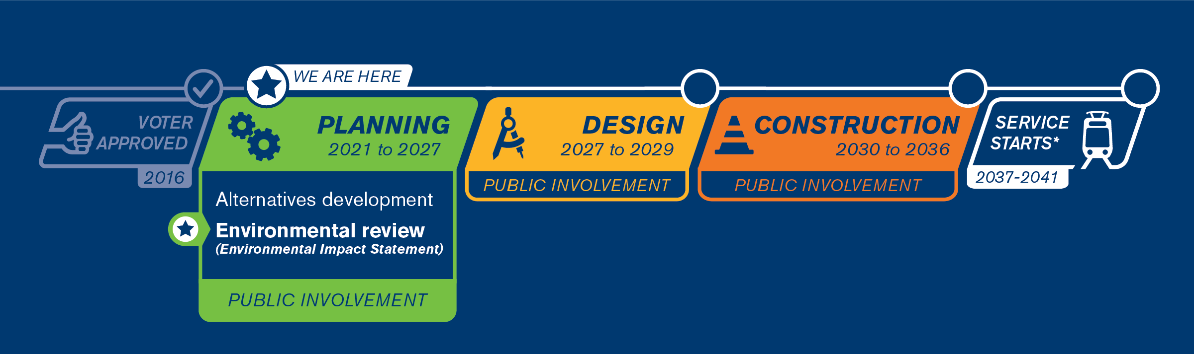
Based on the findings of the Draft EIS and input during the public review and comment period, the Sound Transit Board will identify, confirm, or modify the preferred alternatives for inclusion in the Final EIS. The next step would be the preparation and publication of the Final EIS.
The Sound Transit Board will make their official decision about which route and stations and which OMF North location to build after the Final EIS is published, which we expect to happen in or around 2027. Assuming the Federal Transit Administration completes a NEPA process, they would issue a NEPA decision (called a Record of Decision, or ROD) after the Sound Transit Board’s decision.
Learn more about the project timeline.
What can I expect as a project neighbor?
If you are a resident, business, or property owner near a potential Everett Link route, station, or OMF North location, we encourage you to sign up for project email updates to ensure you have the most recent information.
The EIS process will evaluate potential effects of alternatives on property following further design work. Based on early plans, if it appears your property may be affected under any of the alternatives being studied, we will notify you in advance of the Draft EIS publication.
The Everett Link Extension route and station locations will not be finalized until the Record of Decision has been issued, currently expected in 2027.
Information about effects on property is preliminary until we get further into the design phase of the project, which is currently estimated to last from around 2027 to 2029.
You can learn more about this process in our Property Owner Guide.
If you have questions or concerns about potential effects on property, please contact everettlink@soundtransit.org or leave a message at 206-370-5533 and our team will reply as soon as possible.